| Located in the country of Tanzania along the border with Kenya, Mt. Kilimanjaro is the highest mountain in Africa. Also known as Kilima Dscharo, Oldoinyo Oibor (Masai) and Kilima Njaro (Swahili), it is dormant volcano with three cones: Shira, Mawenzi (elevation 7,564 ft./5,354 m.), and the highest and youngest, Kibo (elevation 19,336 ft./5,895 m.). Although only 3 degrees south of the equator, the mountain is topped with snow and ice. The base of the mountain is 40 mi. (60 km.) in diameter and the climb to Kibo's Uhuru summit is technically feasible by walking. |
|
 NASA Space Shuttle Photo Larger Image (131k JPEG) |
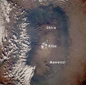
This image, taken by astronauts aboard the Space Shuttle, shows Mt. Kilimanjaro and its three volcanic cones. North is to the right. While Kibo has not been active in modern times, steam and sulfur are occassionally emitted. The crater atop Kibo is 1.5 mi. (2.25 km) wide. Shira, topped by a broad plateau, has experienced significant erosion while Mawenzi is a steep, rocky peak with 1,600 ft (0.5km) - 4,900 ft (1.5km) cliffs on all sides. Mawenzi is the third highest peak in Africa. |
