Geography From Space

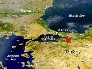
Turkey is bordered by the Black Sea to the north and the Mediterranean Sea to the south. Turkey has a long history of earthquakes. Sitting north of the North Anatolian fault system, Turkey experienced more than 30 earthquakes over magnitude 7.0 during the 20th century. The 1999 earthquake occurred on August 19 at 1:39 UTC and was centered about 11 km (7 mi) southeast of the city of Izmit.
The Answer:
Turkey
Map
Image
SeaWiFS Image courtesy of ORBIMAGE
Larger Image (85k JPEG)

This image shows the northwest corner of Turkey. The approximate epicenter of the August 19, 1999 earthquake is indicated by the red dot. Istanbul (formerly Constantinople) is located northwest of Izmit along the Bosporus. The 7.4 quake claimed over 17,100 lives and damaged historic buildings. That quake was followed by numerous aftershocks and another strong quake struck 100 km east of Izmit on November 12, 1999.

Next Image

Exit Quiz
Geography From Space '99
©2000 National Air and Space Museum