Geography From Space

The Great Wall of China extends 2,400 km (1,500 mi) across Northern China from Gansu Province to the Yellow Sea. The Wall consists of many walls first interconnected in the 3rd Century B.C. The Wall's present form is largely due to improvements made during the Ming dynasty (1368-1644). Built to protect China's northern border from invaders, the Wall averages 7.6m (25ft) tall and has watch towers dotted along its length. Today, portions of the Wall are in need of restoration.
The Answer:
Great Wall of China
Map

Image
NASA SIR-C/X-SAR Image
Enlarged Image (103k JPEG)
Hi-Res Image (228k JPEG)

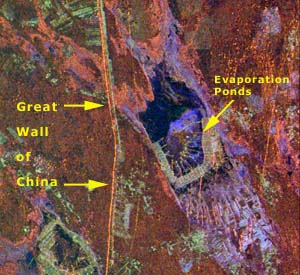
Segments of the Great Wall of China can be seen in images from the Spaceborne Imaging Radar-C/X-band Synthetic Aperture Radar (SIR-C/X-SAR) instrument flown on the Space Shuttle in April 1994. This enlargement shows a section of the Wall in a desert region about 730 km (440 mi) from Beijing. The orange line indicates portions of the Wall dating to the 15th Century. Other sections of the Wall are many centuries older. Here the Wall ranges from 5 to 8 m (16 to 26 ft) high. The angular features at center of the image are salt evaporation ponds. The image is presented in false color, with different colors representing different frequencies and polarizations of the radar signals.

Next Image

Exit Quiz
Geography From Space '99
©2000 National Air and Space Museum