Geography From Space

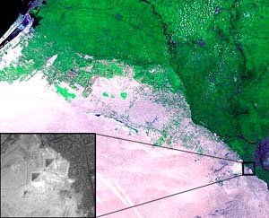
Cairo, the largest city in Egypt, is located on the Nile River. The area has long been an important center of commerce and culture. The Pyramids of Giza were built as tombs and monuments to rulers of ancient Egypt. At the time they were built, the pyramids were near the Nile, but the river has since changed course. Today, greater Cairo is home to millions of people. The urbanized area of Cairo now reaches to the desert fringes where the pyramids were built thousands of years ago.

The Answer:
Cairo
Map

Image
Landsat Images courtesy of USGS/EROS Data Center
Larger version of color Landsat 7 image (69k JPEG)
Larger version of hi-res Inset image (31k JPEG)

This 1999 color Landsat image shows Cairo along the Nile river delta (color image). The strong contrast between the desert area on the left and the darker area on the right indicates the boundary of the Nile River delta. The inset black and white image shows the Pyramids of Giza and their proximity to the modern city's edge.

Next Image

Exit Quiz
Geography From Space '99
©2000 National Air and Space Museum