 |
|---|
| Plate P-15 |
|
|---|
| Plate P-15 |
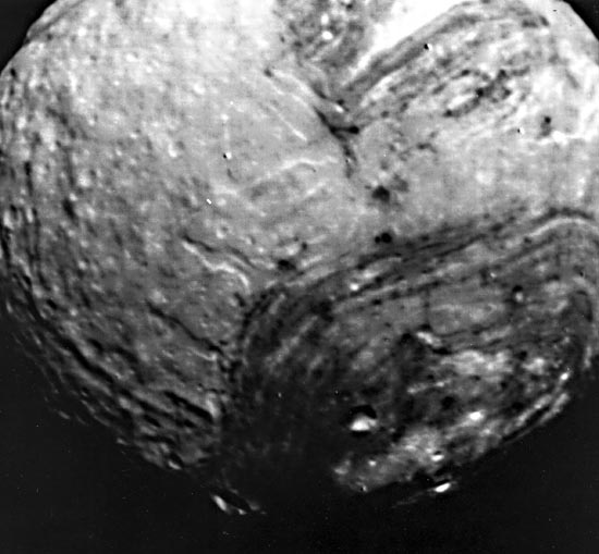
Until recently, the major satellites of Uranus appeared as little more than specks of light in the largest terrestrial telescopes. In January 1986, Voyager 2 passed by the Uranian system to make the detailed observations shown in this Plate. The highest resolution images of any outer-planet satellite were obtained for Miranda, the innermost large (480-km diameter) satellite in the system. A combination of spacecraft motion compensation, ground-based data reception, and computer-processing has yielded images of Miranda with 600- to 800-m resolution, as shown on the facing page. Preliminary findings hint at some fascinating, almost bizarre features on this satellite's surface.
| Figure P-15.1 | Figure P-15.2 |
|---|---|
 |
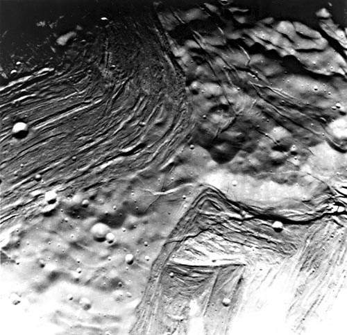 |
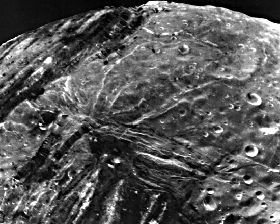
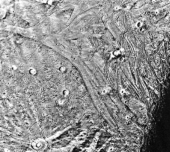
The Plate image at the top shows much of Miranda at 3-km resolution. Distinctive brightness variations, perhaps analogous to those on Iapetus (Plate P-14), are evident. Two different terrain types-heavily cratered bright terrain and a topographically lower, darker grooved terrain arranged in oval to polygonal blotches-dominate the surface. Scarps and cliffs, sinuous troughs (canyons?), and deep clefts cutting the terrain suggest more geologic activity than expected for a small icy world. Figure P-15.1, an oblique view of Miranda, reveals steep high-angle faults that expose a vertical stratigraphy in the crust. Some sinuous scarps might represent thrust faults, suggesting severe horizontal motions of the crust. The grooves and troughs, a few km deep, reveal materials of different albedos, possibly indicating changes in composition or age. Diversity of fracture directions, along with the brightness variations, imply a long complex geologic history for this presumably older region of the Miranda surface. Figure P-15.2 illustrates differences in morphology between older heavily cratered terrain and dark grooved or chevron terrain. Patches of such grooved terrain were informally tabbed "racetrack," "flapjack," or "circus maximus" by Voyager scientists.
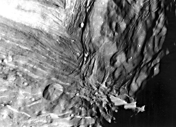
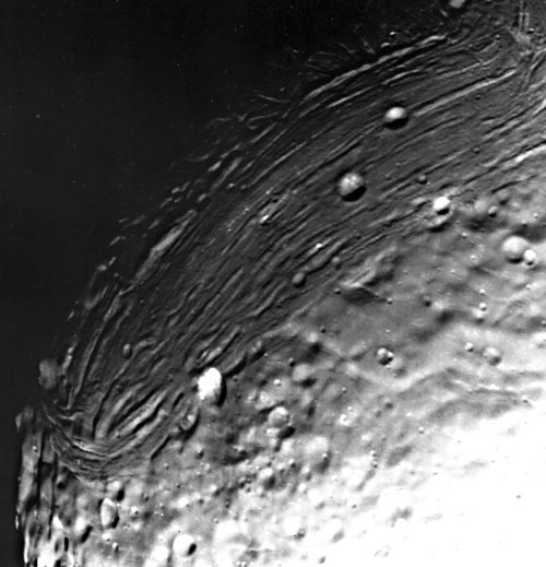
Figure P-15.3 offers more evidence of the intensity of both vertical and horizontal deformation on Miranda. A near-vertical, stratified scarp 8 to 10 km in height (upper right) represents the highest cliff known in the solar system (even exceeding the relief of the huge cliffs in Valles Marineris on Mars and more than three times the relief of the Grand Canyon). Vertical grooves (from shearing between fault blocks?) appear on the cliff face. Such a huge cliff, remaining intact, is quite surprising on a small icy body.
| Figure P-15.3 | Figure P-15.4 |
|---|---|
 |
 |
Troughs and ridges are well displayed in Figure P-15.4. Older complexly grooved terrain possessing intersecting curvilinear ridges and troughs is commonly truncated by younger linear grooved terrain, similar to relationships observed on Jupiter´s satellite, Ganymede (Figure P-12.2).
So far, only four bodies in the solar system show evidence of horizontal crustal movement: Earth, Mercury, Venus, and now Miranda. Internal heat in larger silicate planets was believed to be necessary to drive intense horizontal tectonism; yet Miranda, a low-density ice world, displays convincing signs of such processes. Voyager scientists speculate that Miranda might have been disrupted by giant impacts early in its history (perhaps 4 Ga ago) and later re-accreted heterogeneously. If this happened after some differentiation that separated heavier rock from ice and volatiles, a patchwork of terrains (such as the "flapjack" and "racetrack" types) would result as readjustments of crustal blocks of differing composition and physical properties occurred during continuing accretion.
Second out from Uranus, Ariel ((Figure P-15.5, below) displays no "racetracks" or "flapjacks," but has a variety of intriguing features. Although Ariel´s surface superficially resembles several Saturnian satellites (especially Enceladus, Plate P-14), there are canyons on this 1200-km diameter Uranian moon that apparently have been flooded by ice volcanism. In the lower right of the figure, near the terminator, a series of valleys resembles glacially carved valleys on Earth. These valleys probably formed as grabens that were subsequently flooded, with later faulting and more flooding. Some sinuous features may have formed by thrusting in these flow-like deposits.
| Figure P-15.5 | Figure P-15.6 |
|---|---|
 |
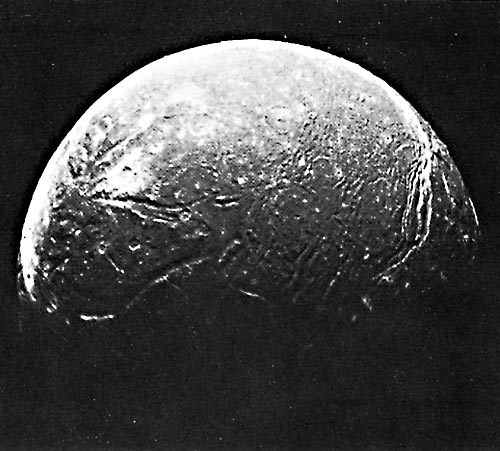 |
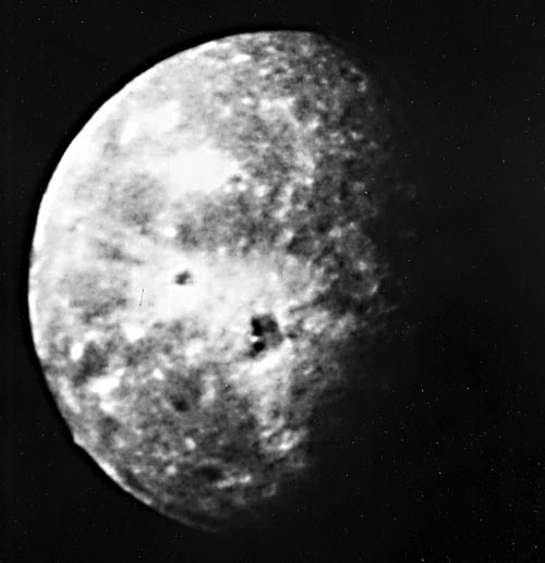
Figure P-15.6 is the best Voyager image of Oberon, the outermost larger Uranian satellite. At 12-km resolution, large impact craters with extremely bright rays of ejecta are conspicuous. In the center of Oberon´s disc is an apparent impact crater with dark deposits on its floor adjacent to a large central peak. This material may be icy carbon-rich substances brought to the crater floor as impact melt. A 6-km high mountain is seen on the lower left limb. Thus, Oberon, too, hosts tantalizing geologic features that must await future visits for more detailed interpretation.
The Voyager observations of these unexpected features in the Uranian system once more astonished comparative planetologists, even after they had absorbed the surprising diversity of geologic features and processes found as this spacecraft provided first looks at the Jovian and Saturnian systems. No doubt still more surprises are in store when geoscientists obtain pictures of the Neptunian system during the Voyager flyby in August of 1989. 86-H-72.
Continue to References| Chapter 10 Table of Contents.| Return to Home Page| Complete Table of Contents|