
The study of landforms, their structure and development, includes the need to illustrate both the findings of an investigation and the character of the landforms investigated. Geomorphologists have used a variety of methods of illustration, including sketches, block diagrams, and various types of photography and other imagery, both from the ground and from the air, to show features of the Earth´s land surface. The geomorphological map, in its various forms, represents recent efforts of many geomorphologists, including most European practitioners, to develop a method of graphical display of the features of the Earth´s physical surface. These detailed maps have become, for them, not only a means of illustration, but a major research instrument in both theoretical and applied geomorphology (Figure 1l-l).
Throughout the 19th century and into the early years of the 20th century, the study of landforms was dominated by a static descriptive physiography. Some investigators in Europe and the United States recognized the influence of dynamic forces on the landscape. In Switzerland, Agassiz saw the erosive power of ice in the Alps. John Wesley Powell recognized the force of water in the carving of the Grand Canyon. Ferdinand Hayden noted the presence of volcanism and the landscape-shaping power of endogenic force beneath the geysers and boiling mud pots of the Yellowstone volcanic region. G. K. Gilbert posed the idea of a landscape in dynamic equilibrium in his studies in the Henry Mountains in Utah. In 1899, with the publication of The Geographical Cycle, William Morris Davis introduced into the stagnant physiography of his time what King (1968) calls "a semblance of dynamism." Davis´ concept of the "cycle of erosion" produced a radical change in geomorphology. It suggested forcefully that the landscape was dynamic and constantly evolving through a cycle of change due to the external forces of water and the atmosphere. Although his ideas have been extensively criticized and to some extent discredited in their original form, Davis´ dynamic approach to the landscape has been indelibly stamped on geomorphology. A similar dynamism was introduced into French geomorphology at about the same time through the development of the "Geologie Dynamique." However, in practice, most geomorphological research continued to be dominated by a static descriptive physiography in which the landscape was described in writing, generally accompanied by artistic block diagrams drawn to illustrate the author´s conclusions. Although these diagrams were often excellent illustrations of geomorphological processes, they tended to be idealized qualitative portraits rather than quantitatively verifiable graphic analyses of the landscape.
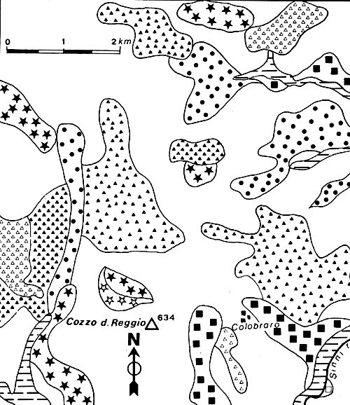
| Figure 11.1. A sample area of the detailed geomorphological map of the upper Dee valley, Aberdeenshire, Scotland, Reprinted with permission from Progress in Geomorphology, Institute of British Geographers Special Publication No. 7, R.S. Crofts, "Detailed Geomorphological Mapping and Land Evaluation in Highland Scotland, " 1974. |  |
|---|
By the 1920s, photography had developed to a fairly high level of sophistication and should have been useful to geomorphologists. It was generally ignored in favor of block diagrams or given a very low rating as a research tool. There were a few early users of photography in landform study. As early as 1840, the Frenchman, J. Arago, suggested that photography could be useful in topographic mapping. The early photographers and balloonists, Nadar and Triboulet, experimented with aerial photography and the view it provided of the landscape. In 1899, Albert Heim published his photographs and observations made during a balloon flight over the Alps; he is probably the first person to use aerial photography in geomorphological research. During the first World War, aerial photographs were used to investigate terrain and map battlefield positions.
In the early part of the 20th century, until World War II, most geomorphological research was focused on specific sites or specific factors of the landscape rather than at the land from a comprehensive regional perspective. Fenneman´s Physiography of the Western United States and Physiography of the Eastern United States (1931, 1938) were perhaps an exception, although his interests were primarily qualitative and descriptive and did not include quantitative factors by which landscapes might be analyzed and compared. Visualization of regional landscapes by means of physiographic or landform maps of the United States and elsewhere were drawn by Raisz, Lobeck, and others. These maps are intermediate between topographic and geomorphic units maps. As a form of block diagram, the physiographic map shows sketched perspective representation of actual landforms as envisioned from an oblique "birds-eye" view. Figure 11-2 reproduces a section of the physiographic map of Utah, prepared by M. Ridd.
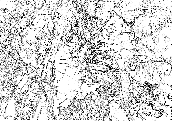 |
Figure 11.2. A part of the "Landforms of Utah" map prepared by Merrill K. Ridd. |
|---|
World War II represented a fundamental divide for geomorphology both theoretically and technically. Great advances were made, technologically, in the use of aerial photographs and airphoto interpretation for the terrain analysis necessary for the highly mobile style of warfare that characterized World War II. Better photo equipment, films, and instrumentation for interpretation became available, increasing the ability to study landform features by means of aerial photographs. Quantitative analytical techniques, developed in other sciences, were applied to geomorphic research (e.g., Strahler, 1957). Geomorphologists, particularly in Europe, became interested in comprehensive regional analysis of landforms that considered together all the aspects and features of the landscape. Investigators realized that processes in landform development were more complex than the relatively simple Davisian cycle of uplift, downwearing to a peneplain, and rejuvenation. Questions were asked about the nature of past landform processes and their relationship to present processes. How could various landscapes be compared and contrasted with one another, and what were the significances of landforms and the influence of relief on such things as vegetation, hydrology, and the human cultural development of the area? From these and other questions arose the need for a new paradigm in geomorphology. Because the landscape was complex, in order to pursue orderly scientific research, geomorphologists sought an objective scientific method of graphic portrayal of the complex factors of landforms. The qualitative descriptions and artistic diagrams of the physiographers did not provide the information necessary for detailed and accurate analytical studies of landforms. As Klimaszewski (1982) has said, "It was only after World War II that the preparation of detailed geomorphological maps on the basis of a systematic mapping of landforms was advanced as a need or even a necessity." In the 1950s and 1960s, the science of geomorphology became, in the words of Fairbridge (1968), "the analytic physiography of the Earth´s surface," and the detailed geomorphological map became, in many countries, "the main research method in geomorphology" (Demek, 1982).Research in modern analytic geomorphology has developed around five fundamental landform concepts:
The graphic portrayal of these five concepts involves a complex and often difficult set of analytical and cartographic procedures. The development of theory, procedures, and cartographic legends has taken a great deal of time and effort, particularly by European geomorphologists, over the last 30 years. Although all agree on the need for detailed geomorphological maps in order to further geomorphological research and to enhance the value of geomorphology in applied landscape analysis, considerable disagreement exists as to the correct character and content of geomorphological maps.
Some of the earliest detailed geomorphological maps were published by Siegfried Passarge in 1914 in his Morphological Atlas. From that time to the end of World War II, a few detailed maps of local regions were published by some European geomorphologists and detailed geomorphological surveys were occasionally made, but it was not until the 18th Congress of the International Geographical Union (IGU) in Rio de Janeiro in 1956 that the importance of detailed geomorphological maps received international acknowledgment. Two years later, at the IGU congress in Stockholm, the Subcommission on Geomorphological Mapping was created and was given three tasks:
Before the establishment of the subcommission, detailed geomorphological maps were being prepared in a number of countries, including Switzerland, U.S.S.R., Poland, France, Czechoslovakia, Japan, Belgium, and Hungary. Because of national differences in content and methodology, the maps were generally not comparable and were therefore of limited use for wider area geomorphological analysis. European geomorphologists recognized the need for a single unified technique, including a common legend, for comprehensive mapping. At a meeting of the subcommission in Krakow, Poland, in 1962, representatives of 15 countries established a set of guidelines for preparing geomorphological maps. These guidelines included (Klimaszewski, 1982):
The Subcommission on Geomorphological Mapping met regularly through the 1960s. In 1968, at the IGU Congress in New Delhi, India, it was upgraded to The Commission of Geomorphic Survey and Mapping and was charged with the responsibility of developing a Manual of Detailed Geomorphological Mapping and devising the legend for an International Geomorphological Map of Europe on a scale of 1:2 500 000. The legend, produced in collaboration with many geomorphologists from European countries, was published in 1971 (Bashenina et al., 1971). The Manual, a compilation of articles by 20 geomorphologists, was published in 1972 (Demek, 1972). The first of the 16 projected maps and accompanying texts was published in 1984 (Embleton, 1984).
In spite of the collaborative work by the Commission on Geomorphological Survey and Mapping, a great deal of diversity and disagreement still exists on the nature of geomorphological maps and their contents. The number of legends, representing different approaches and methodologies, has proliferated. For the most part, they represent a particular national or regional outlook and few, if any, meet all the requirements of comprehensive geomorphological mapping. Demek (1982) has pointed out that new developments in geomorphology since 1970 have substantially increased the theoretical and practical significance of geomorphological mapping. There is a better understanding of the competing interactions of endogenetic and exogenetic forces, due to both the new theories of global tectonics and the development of methods of investigating the Earth from space. A new emphasis on "ecological geomorphology" has related the understanding of landscape relief to human life and activity. New research methods have been introduced, particularly in relation to aerial photography, satellite imagery, and radar imagery, along with development of computers to analyze data and provide automated cartographic displays. Although there has been progress, serious problems remain. In addition to the problems of content and methodology, the question of appropriate scales, particularly in the case of small-scale large-area maps, has not been answered. It is important for the future of geomorphology that these questions be settled. Demek maintains that, until they are settled, "there can be no further progress in geomorphology as a science." Wright (1972) divides geomorphological maps into two generalized categories: "Landform Surveys" and "Special Feature Investigations." The first category covers the various types of detailed geomorphological maps. The second category includes specialized maps such as the "Terrain Analogues" of the U.S. Army, which analyze the land only in terms of its trafficability for military vehicles, or Hammond´s (1954) "Small Scale Continental Landform Maps," which, although small-scale and regional in scope, are focused on "actual characteristics of the existing surface rather than genetic interpretations." Hammond´s restricted view takes his work out of the realm of landform surveys.
GEOMORPHOLOGICAL MAPPING THEORY; DEVELOPMENT AND DIVERSITY
In different countries, the development of geomorphological mapping has followed different courses, partially due to the particular interests and emphases of geomorphologists and partially due to real or perceived differences in the landforms found in various regional settings. To date, most detailed geomorphological mapping has been done in Europe by European geomorphologists. In general, American practitioners have been primarily interested in special feature studies or the mapping of special factors of the landscape rather than the development of comprehensive studies. This low degree of interest in comprehensive studies may be due, in part, to a reduced interest in geography and its integrative emphasis in the United States. Some European geomorphologists, including French, Czechoslovakian, and Hungarian workers, have selected the lithological-structural unit as the basic element in landform analysis. Others, such as Polish, Russian, Rumanian, and German geomorphologists, consider the form as the basic unit. The Manual of Detailed Geomorphological Mapping and the Legend to the International Map of Europe on the scale 1:2 500 000 generally follow the Polish, Russian, and German convention. In Great Britain, geomorphologists developed an "empirical system" based on division of the landscape into "slopes and flats." Similar systems have been adopted by some Belgian and Canadian geomorphologists because they make it possible to give quantitative values to all landforms, generally at the expense of genesis and chronology. Some geomorphologists have attempted to combine approaches. In Australia, the Division of Land Research and Regional Survey of The Commonwealth Scientific and Industrial Research Organization (CSIRO) developed a system of geomorphological mapping for resource survey based on a concept of land units and land systems. The concept was "aimed at providing both a basic and functional subdivision of landscape" (Christian and Stewart, 1968). A land unit was conceived as an area dominated by a land surface that had a similar genesis and now has similar topography, soils, vegetation, and climate. A land system was "an assembly of land units which are geographically and genetically related" (Christian, 1958). This system, which is particularly well adapted to rapid reconnaissance surveys of large areas based on information derived from aerial photographs, has been used to map large areas of Australia and New Guinea (Mabbutt and Stewart, 1963).
| Figure 11.3. Four maps constituting a multiple-scale portrayal of the land unit hierarchy in the Near East showing climate, geomorphic, and geologic features of the region and sections within it. Reprinted with permission from Geoforum, Vol. 11, J.A. Howard and C.W. Mitchell, "Phyto-Geomorphic Classification of the landscape," Pergamon Press, Ltd., 1980. |  |
|---|
The development of the international legend, or "Unified Key," and its application to a projected international geomorphological map of Europe, of which the first sheet has now been published, is considered a step forward by most European geomorphologists, but much remains to be done. There is appreciation for, but currently no universal acceptance of, the Unified Key as the one legend to use. Demek (1982) points out the desirability of a single legend for geomorphological maps on various scales, but, he says, the legends proposed so far "do not meet all the requirements." In spite of the many differences, there is an underlying unity to terrain classification. All geomorphologists are concerned with identifying the simplest land unit with low variability, and all are attempting to combine these into a hierarchy of increasingly more complex regions (Gardiner, 1976).
GEOMORPHIC UNITS
Geomorphological mapping begins with the identification of the fundamental units that compose the landscape. Establishment of the nature and character of these units is critical to the success of any geomorphological research. However, there is no single agreed-upon unit that satisfies all types and all scales of research mapping. Miyogi et al. (1970) have described a geomorphic unit in general terms as "an individual, genetically homogeneous landform produced by a definite constructional or destructional geomorphic process." Most geomorphologists would agree with this definition as far as it goes, but would differ widely as to the descriptive characteristics of the genetically homogeneous landform. In addition, although most landforms may be considered as "genetically homogeneous" in terms of present processes, most landforms owe their characteristics, in part, to past processes of a different sort. Wright (1972) has pointed out that ". . .each part of the land surface is the end product of an evolution governed by parent geological material, geomorphological processes, past and present climate, and time." Most geomorphologists would agree that it is necessary to view the landscape in terms of recognizable patterns that are, to some degree, repetitive. As Gardiner (1976) has said, "units of land, however defined, recur in the landscape in recognizable patterns."
There are two general approaches to the question of geomorphic units, which Speight (1974) divides into a Landform Elements Model and a Landform Patterns Model. He sees the two approaches as complementary. Either model can be used to describe any piece of land, with the choice dependent on scale and the purpose of the mapping. In the Landform Elements Model, the units of landscape are compared to "a simply curved geometric surface without inflections," focused on slope and slope measurements. In the Landform Patterns Model, the land surface is seen as a "three-dimensional cyclic or repetitive phenomenon in which simpler elements recur at quasi-regular intervals in a definable pattern." Here the units are those elements that form the patterns. The Russian, Polish, and Czechoslovakian systems of geomorphological mapping are among those that follow the landform pattern model in which the basic units are morphostructures generally fitted into a nested classification of forms (Bashenina, 1978). British geomorphologists and some others use a landform elements model that classifies the basic units of the landscape in geometric terms as facets and segments defined by slope and area measurements (Savigear, 1965). Other national groups have developed systems that follow some variation of the two models.
Differences in the identification of geomorphic units are significantly related to matters of regionalization and scale. At different scales, covering regions of different size, different features can be identified as basic homogeneous units. The choice of unit is dependent on the scale of analysis. Howard and Mitchell (1980) have said that the clearest and simplest basis of classification is "classification of landscapes into homogeneous units suitable to the mapping scale required for the particular purpose." A hierarchy of land units can be readily identified in most regions, depending on the scale of the mapping (Figure 11-3). The landscape is, in the words of Nicholayev (1974), "a multi-tiered geosystem." At each tier, different taxonomic individuals form the basic geomorphic units of the landscape. As broader regions are studied, at smaller scales, smaller features and processes often fade from view while larger features, imperceptible at larger scales, assume prominence.
Geomorphology is a complex subject with multiple approaches to geomorphological analysis and multiple scales of geomorphological mapping. The nature of the geomorphic unit is controlled by the model of analysis chosen and the scale of mapping required. The basic geomorphic unit is not a single feature or entity, but must be carefully selected to be essentially homogeneous and indivisible at the scale chosen. Although all generally agree that the basic geomorphic unit should be a homogeneous entity, it can be defined in terms of genetic or structural pattern, the approach followed by the IGU and most European geomorphologists, or in terms of location and dimensions of geometric elements, along the lines of the British system.
Most detailed geomorphological maps are developed for small areas on quite large scales, typically between 1:10 000 and 1:50 000. A major growing interest in geomorphology is the possibility of wide-area regional analysis of landforms. Such research requires the regionalization of geomorphological maps. A number of methods have been suggested by various workers through which a hierarchy of geomorphological regions can be developed (Gellert, 1972).
APPLICATIONS OF GEOMORPHOLOGICAL MAPPING
The modern detailed geomorphological map provides a unique means of displaying all of the various factors and features of the physical landscape in an orderly scientific fashion. Such a map is the one analytical research tool developed so far by which it is possible to approximate a portrayal of the Earth´s complex surface and its dynamics. It has direct scientific value for research in theoretical geomorphology and likewise serves as a basis from which applied maps may be drawn, focused on special aspects of the landscape, to aid in a variety of different types of applied geomorphological research.
Detailed geomorphological mapping leads to a number of applications to basic scientific research essential to the continued growth and development of geomorphology. As Klimaszewski (1982) pointed out, mapping can:
Barsch and Liedtke (1980) cite other scientific benefits from a program of detailed geomorphological mapping in West Germany, including a greatly increased data base from the necessary field work, an improvement and clarification of geomorphological terminology, enlargement of data processing capability, the intensification of morphodynamic studies, provision of geomorphological documentation in areas of intense development, and an increased cooperation between geomorphologists and other geoscientists.
The complex nature of detailed geomorphological maps tends to limit their usefulness beyond the area of technical geomorphology. As Barsch and Liedtke (1980) point out, these maps are "made by experts for experts." Tricart (1969) notes that " a genuine geomorphological map is an intricate document which can be read only by persons with adequate specialized training." All of these tend to render their information inaccessible to persons outside geomorphology. In spite of this, Tricart maintains that "Geomorphological surveys should constitute one of the basic elements in the preparation of development projects." According to Embleton (1985), geomorphological maps serve several valuable functions. He states that they are primarily "a visual information store." They can also serve to coordinate geomorphic research among workers with diverse concepts and approaches to the subject. In viewing geomorphological phenomena over a wide spatial context, as was required when preparing the IGU Geomorphological Map of Europe on the scale of 2.5 million, all researchers are subject to the discipline of working within an agreed international framework. In education, geomorphological maps can be used with other physical maps to "show the complex integration of the natural environment." Finally, in relation to remote sensing data, Embleton points out that an experienced geomorphologist, mapping the landscape, can more easily and reliably appreciate terrain types depicted on remote sensing images than the analyst without such a background.
A special value of geomorphological mapping lies in its application to particular problems, generally by the use of limited maps showing only those geomorphic features relevant to the particular question at hand. Such maps either are derived, by simplification, from the detailed maps, or are prepared using only the necessary data. Derivative maps are often the more desirable because it is always possible to refer back to the detailed maps should further information be needed.
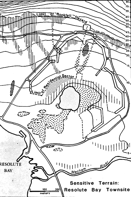
Geomorphological maps are of great value in the general field of Environmental Management, particularly at the planning stage. Cook and Doornkamp (1974) found geomorphological maps to be of principal utility at the initial field investigation stage of analysis for environmental concerns. They also considered the maps to be valuable as the basis for a number of special-purpose maps useful in various stages of environmental management. Panizza (1978) created a series of geomorphological stability maps for areas of northern Italy, southern Italy, and east-central Nigeria. Their purpose was to aid in coherent land-use planning in sensitive areas. These were simplified maps based "on the one hand, on morphogenetic process causing instability and, on the other hand, on the lithology involved in degradation." The resulting maps were simple and easy to read, showing only the information relevant to stability (Figure 11-4). The stability maps were developed from detailed maps drawn after a full geomorphological survey which, Panizza says, "is a prerequisite to the development of maps useful for planning purposes." Geomorphological stability maps were also developed by Rosenfeld (1976) as environmental planning documents in connection with the development of a new township accommodating 800 to 1000 persons at Resolute Bay, Northwest Territories, Canada (Figure 11-5). In a periglacial environment, microfeatures of the area such as patterned ground, solifluction lobes, meltwater channels, and eustatic strandlines were mapped. The data were used to choose the best location among five alternative sites and to plan the use of open space in the community so as to avoid concentrated activities in areas of sensitive terrain. The purpose of the planning was not only to deal with the structural engineering concerns of construction in a difficult environment but also to use the land in such a way as to enhance the aesthetic quality of the community.
The application of comprehensive geomorphological surveying and mapping to environmental engineering concerns, such as highway planning and construction, is just beginning to take hold. Brunsden et al. (1975) say that "there is an obvious need for additional geomorphic information . . . (beyond the geologic information generally utilized in highway planning) . . . since surface form and the spatial pattern of geomorphological processes often influence the choice of a route." They see the use of different types of applied geomorphological maps at different stages of planning and construction. Small-scale maps can provide the regional analysis of an area that would be valuable at the initial feasibility stage of planning. Large-scale small-area maps would be valuable for questions of site investigation and could help in forecasting behavior during and after construction.
Various techniques by which sections of the landscape can be viewed from a distance have been classified under the general term "Remote Sensing." For geomorphologists, these include aerial photography and satellite imagery, both photographic and telemetered, recorded at various wavelengths or bands of the electromagnetic spectrum. The wavelengths used have included several in the visible light range, several in the infrared range, and radar in the microwave range. Sound-wave studies, or sonar, and studies of regional variations in the Earth´s magnetic field can also be classified as remote sensing. The use of side-scan sonar shows great promise for studying the geomorphology of the ocean floor. With the development of the Geological Long Range Inclined Asdic (GLORIA) by the National Institute of Oceanography in Great Britain, detailed studies of the deep ocean floor became possible (Laughton, 1980). A number of morphological studies using GLORIA have been made of midoceanic ridges (e.g., Searle, 1979; Searle and Laughton, 198 1) and of submarine fan morphology below the deltas of several major rivers (Damuth et al., 1983). Geomorphological mapping of the deep ocean floor has recently been advanced with the development of a combination side-scan sonar and seafloor mapping system (SeaMARC II) (e.g., Hussong and Fryer, 1983; Blackinton and Hussong, 1983; see also Chapter 13). Magnetic, gravity, and seismic studies customarily are not used in geomorphological research because the information they provide refers primarily to subsurface states; however, knowledge of the Earth;s interior can sometimes assist in recognizing and interpreting surface phenomena (e.g., using gravity or magnetic anomalies to disclose the presence of a dike beneath a ridge; remanent magnetization anomalies were shown by Mahrer and Bradley (1983) to relate to morphology of alluvial fans on which arroyos have developed).
Working with aerial photographs, geomorphologists have been able to view sizable portions of the land surface at one time from a map perspective. Although individual aerial photographs are limited in area, the process of assembling groups of adjacent photos into a mosaic has provided a direct regional perspective of larger areas. The opportunity to see the landscape on a regional scale has often included the ability to perceive features that were not perceptible on site or on larger, more localized scales. Throughout the 1950s and 1960s, as the techniques of remote sensing were refined, as new film emulsions became available, and as the new technology of orbital imagery came on line, remote sensing became more and more a dominant factor in geomorphological research.
Today, as a general rule, the first step in a comprehensive geomorphological survey is the identification and mapping of geomorphic units, using aerial stereopairs of the area to be studied. From aerial photography, most of the morphology can be identified, and many of the questions of morphogenesis, such as denudational versus depositional processes, can be answered. Slope angles can be estimated and classified, and the relative relief of all but small features can be determined with acceptable accuracy. The geomorphologist goes to the field with the basic structure of the survey well outlined and mapped from aerial photographs.
The second step in the survey is the field work. The accuracy of the aerial photointerpretation must be checked on site, and measurements of small features must be made. Questions of morphochronology, such as the sequential history of terraces, must be ascertained. Remote sensing techniques, using aerial photographs, are valuable in providing the basic prefield framework of the study, but a complete, accurate geomorphic survey leading to true detailed geomorphological mapping requires extensive field work.
When the field work has been completed and the preliminary map has been thoroughly checked, the final detailed geomorphological map is drawn, generally in multiple colors using a complex symbology.
Orbital imagery, first in the form of photographs taken by astronauts and then as telemetered imagery from unmanned satellites, provided geomorphologists with a new perspective on the Earth´s landscape. From the outset, great hope was expressed for its value, but to date, the importance of orbital imagery in providing new insights into the physical geography of our planet has not been unequivocally established. Over the past 10 to 15 years, geomorphologists have used orbital imagery of various types as the basis of geomorphological mapping with some success. Verstappen and vanZuidam (1970) used several types of orbital imagery available at the time to test its value in mapping a remote region of the central Sahara. With photos taken by Gemini and Apollo astronauts and telemetered imagery from Nimbus and ESSA satellites, they endeavored to develop geomorphological and geological reconnaissance maps of Lake Chad and of the Tibesti Massif. They concluded that the imagery then available was useful "for discovering very large features and structures that may otherwise escape attention because of a lack of a comprehensive image." However, they felt that the imagery needed to be of higher resolution if it were to provide new information not already available by other means. Slaney (1974) looked at some of the first Earth Resources Technology Satellite (ERTS; now Landsat) imagery and found that its limited ground resolution would only be moderately useful for mapping purposes. He did find it helpful as an educational tool in reports, as a base map underlying other data, as a source of information in defining "broad targets of particular interest," and as a catalyst to provide "inspiration for new ideas and to promote further thoughts about established concepts." Palabekinoglu (1974), also studying data from ERTS-1, concluded that "intensive interpretation of the satellite imagery would help the geoscientist to become more familiar with the surface of our entire Earth." The problem of scale was considered a serious limiting factor in the usefulness of satellite imagery. Mukerjee (1982) said, "the small scale of orbital photographs limits the possibility of interpretation to major relief features only." On the other hand, Bedi (1982) found that geomorphological maps could be easily prepared from either aerial photographs or Landsat imagery "supplemented by nominal field work."
At the present time, one area in which satellite imagery seems to provide a definite advantage over aerial photography is in the realm of large-area small-scale geomorphological studies. The ability to perceive mega- and macro-structures, using mosaics of Landsat images, promises to provide new information and new mapping techniques. Astinov et al. (1976), in citing contributions of small-scale satellite imagery to geomorphology, point out that it has "changed our view of the formation of large relief forms." Bashenina and Tal´Skaya (1981) have used space imagery to construct a geomorphological map of the world on the scale of 1:15000000. They found the imagery to be very satisfactory as they were able to perceive all the information pertinent to a geomorphological map at this generalized scale (Figure 11-6). Canoba (1982) found that the perception level of Landsat Multispectral Scanner (MSS) imagery of the Argentine Pampa permitted the development of "a preliminary geomorphological map at a scale of 1:1000000 directly without going through a complete cartographic generalization process starting from larger scale maps." He found that, with adequate data from other sources, he was able to develop a good standard geomorphological map. Although the satellite imagery did not provide any unique information, the direct regional mapping procedure was valuable because of the savings in time, effort, and cost. As Rao and Bedi (1982) have said, "Remote sensing technology has reversed the conventional pattern of geomorphological surveys, where studies were carried out locally and then a regional picture was constructed. Now it is possible to do regional studies straight away on aerospace imagery and then the smaller areas selected for detailed work."
| Figure 11.6. Morphostructural map of Alaska drawn from space imagery. Reprinted with permission from The Soviet Journal of Remote Sensing, No. 6, N.V. Tal´Skaya, "Space Imagery Analysis for a Geomorphological Map of the World," 1981. |  |
|---|
A geomorphologic units map of Alaska, prepared originally at 1:15000000. Morphostructures: I. Continental Platforms: 1 -Depositional plains of platform downbuckles on a basement lying at a great depth, and 2 -Denudational plains of homoclinal and locally dislocated strata. II. Epigeosyncline orogenic belts: 3 -Block-fold ranges and massifs, and 4 -Arch-fold-block and block-himoclinal ranges and massifs. III. Orogenic belts formed by rifting: 5 -Fold-block ranges and massifs on Mesozoic rocks, 6 -ARch-fold-block and block-overthrust ranges and massifs on Mesozoic rocks, 7 -Arch-block and block-homoclinal ranges and massifs on Paleozoic rocks, 8 -Block highlands inheriting median massifs, 9 -Ranges within highlands (complex horsts), and 10 -Uplands fragmented by differential block movements. Plains of foredeeps and intermontane basins: 11 -Depositional and 12 -Depositional/denudational and denudational. Morphostructures of tectonic and igneous origin: 13 -Ranges and massifs formed by horst development and igneous intrusions, and 14 -Ranges and massifs composed of volcanic rocks. IV. Deep-seated faults: 15a -Boundaries of deep-seated fault zones, and 15b -Deep-Seated faults responsible for the block character of morphostructures. V. Minor morphostructures and individual landforms: 16 -Depressions formed by grabens, 17 -Rift depressions, 18 -Horst massifs formed by igneous intrusions, 19 -Denudation scarps, and 20 -Major river valleys.
Studies in which Landsat imagery was the principal data base for classifying and mapping landforms began to appear in the literature by the mid-1970s. Among these were a classification of physiography from ERTS imagery (Ulaby and McNaughton, 1975), application of Landsat imagery to southwestern Turkey (Kayan and Klemas, 1978), and use of RBV imagery in geomorphic mapping of Kansas (Cochran and Browne, 1981). The work of Bedi (1982), already cited, involved mapping from Landsat images of several areas in India. A landforms map (Figure 11-7a) of part of New South Wales, Australia, produced by C. F. Pain (1985), modifies a landscape profile classification scheme (Figure 11-7b) developed by C. D. Ollier (1967) to generate a set of units that are well suited to analysis of a variety of terrains. Townshend (1981) describes an approach to regionalization of terrain using remotely sensed data from space.
Today, advances in the resolution of satellite imagery have increased its use in geomorphological mapping, particularly on small scales. However, it is still not clear how truly useful Landsat and other orbital imagery is in providing new data not available from other sources. Landsat imagery has proved valuable in providing pictures of areas in which, because of remoteness of location or political conditions, investigations by aircraft or on the ground are not possible. The use of radar imagery also promises to provide pictures of areas that are difficult to photograph due to cloud conditions. The real potential of satellite imagery is still to be realized. As geomorphologists have investigated landscapes from larger regional perspectives, they have found that, at different scale levels, different types of forms are evident. At the present time, most regional studies are viewed as generalizations from large-scale small areas to small-scale large areas. But regionalization is more than generalization. Regionalization through generalization is prone to the dangers of subjectivity. At each level of generalization, individual investigators must decide how to generalize, choosing what to include and what to eliminate from the analysis. A regional perspective from space provides an objective portrait, relatively free from unintentional bias. The regional view helps place individual landforms and individual processes into a wider geographic context. As previously mentioned, it has been impossible for geomorphologists to develop a single mapping key that satisfies the requirements of all regions at all scales. A major reason is that landforms differ significantly from region to region and require different cartographic symbolization. The proliferation of geomorphological mapping legends is a recognition of the complexity of geomorphological reality. It is relatively easy to classify individual geomorphic processes into a series of basic categories such as tectonic, fluvial, or eolian, but landforms are almost always the result of a complex mixture of processes interacting on the landscape. From the regional variations in the mix of geomorphic processes comes the multitude of often unique landforms that characterize the surface of the Earth. Space imagery provides a direct perspective of the regional mix. Through space imagery and the geomorphological mapping and analysis derived from it, we can have a better view of the integrated dynamics forming the surface of our planet.
To further demonstrate the utility of Landsat imagery and the value of mapping from the regional perspective in geomorphological research, a regional geomorphological map of the Colorado River Delta Region in Mexico (Figure 11-8) has been developed from a black and white Landsat Band 7 MSS image of the area taken December 23, 1975 (see Plate D-12). The scale of the image and of the original map was approximately 1:330 000, but it has been reduced here to about 1:850 000. All of the units mapped can be perceived in the Landsat scene. Geomorphic units were defined by relatively obvious combinations of tone and texture in the scene. Identification of the character of the units, such as mountains, terraces, or sand dunes, was made by a combination of shape, tone, texture, and location context. Most of the boundaries between geomorphic units were relatively sharply defined by changes in tone. Terraces and the edges of some alluvial fans were also definable by change of tone. Faults and lineaments were mapped where obvious, and fault movement has been indicated where perceptible. Other features were also identified by shape, tone, and location context.
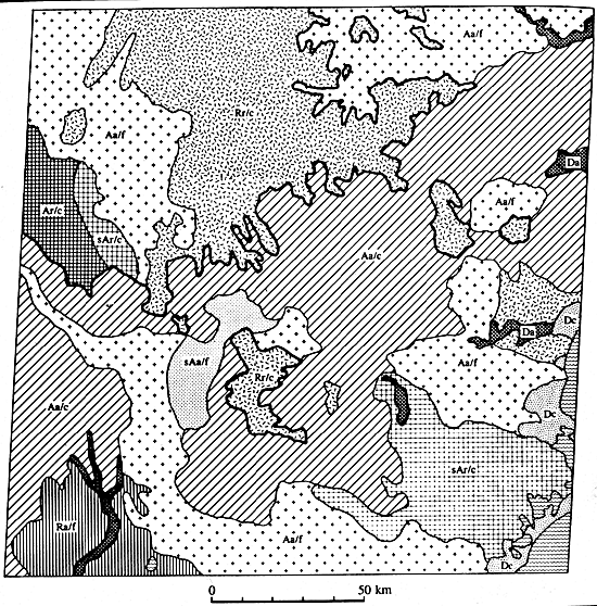 |
Figure 11.7a. A geomorphic units map of an area in eastern New South Wales, prepared from Landsat MSS scene 2045-23005-7. Units are defined in legend (from Pain, 1985). |
|---|
Some of the symbols used on the map, such as those for alluvial fans, terraces, and transverse dunes, were taken from the legend contained in the ITC system for Geomorphological Survey (Verstappen and vanZuidam, 1975). Others, such as those for salt pans and for the geothermal field, were made up because the ITC system had no symbols for these features. In most European geomorphological mapping systems, geomorphic units or lithology or both are indicated by color. Since this map is entirely black and white, patterns for the geomorphic units were chosen that could be easily drawn and would stand out clearly on the completed map. Lithologic identification was made from The Reconnaissance Geological Map of the State of Baja California by Gastil et al. (1975). Other ancillary information was drawn from books and articles by Lowman (1968), Merifield and Lamar (1975), and Thompson (1968). It should be emphasized that this map was drawn entirely as a desk exercise. No field work was undertaken either to check the accuracy of the analysis or to supply additional information. It is possible that errors of identification would be discovered and certain that additional morphometric information could be gained from field investigation.
The northern end of the Gulf of California tectonic trough contains the delta of a major river system, but unlike many other deltas, different active geomorphic processes compete for dominance with the deltaic processes. From the perspective of the basic order of the processes operating in the region, it would be better entitled "an active tectonic trough, in an area of strong structural control, within an arid climate region that contains a major river delta."
| Figure 11.7b. A classification of generalized landscape profiles in which R(r) = round, F(f) = flat, and A(a) = angular, for inferfluve (capital letter and valley losercase letter) profiles (from Ollier, 1967). | 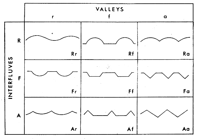 |
|---|
The geomorphological region is bordered on the west by the Sierra Juarez and Sierra San Pedro Martir, a section of the Peninsular Ranges that extend southward from near Los Angeles to form the backbone of Baja California. The eastern side is bordered by the Tinajas Altas Ranges of Arizona. The ranges on both sides of the trough are formed of Mesozoic granitic rocks. The north end of the region, including the Salton Sea and the Imperial Valley, are outside of the mapped area. The southern boundary of the region is formed by the Gulf of California. The Sierra Pinacate volcanic field (Plate V-4) lies off the image just to the southeast of the mapped area.
Mountain ranges within the trough are a complex mixture of age and lithology. A small volcanic center, consisting of an inactive cinder cone and surrounding geothermal field, is located at Cerro Prieto. Here the Mexican government has constructed a 75-megawatt geothermal power station, its cooling reservoir clearly visible on the Landsat image. Alignment of the volcanic center and surface manifestations of the San Jacinto fault system in the delta flat, perceptible as variations in tone and shape of agricultural fields on Landsat, may indicate a relationship between volcanism and faulting in the area (Merifield and Lamar, 1975).
Several faults or fault systems and a number of lineaments, which may or may not be faults, were mapped from the image. The Sierra de Los Cucapas has four distinct northwest-southeast-trending lineaments that are undoubtedly faults. Two of these show clear offsets characteristic of right lateral strike-slip movement. The prominent Agua Blanca fault is easily recognized as a gash across the eroded and dissected upland region west of Valle de la Trinidad. This is known to be a strike-slip fault, although it is difficult to confirm any offsets in this particular scene.
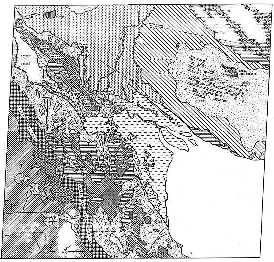 |
Figure 11.8a. Geomorphological units map of the Colorado delta region, Baja California, drawn from Landsat MSS Band 7 image. |
|---|
The climate of the region is arid, with two distinct arid climatic subregimes operating in different parts of the area. To the east and south of the delta is the Sonoran Mesa, which is a desert dominated by eolian geomorphic processes. The central portion, west and south of the Sierra del Rosario, is an extensive sand sea with long ridges of prominent transverse dunes oriented with the prevailing wind (See Plate E-11). A dark spot in the north-central portion of the desert is an anomalous lake in this very dry region. Merifield and Lamar (1975) suggest that the lake may be caused by the impoundment of ground water behind a fault. The geology of the Sonoran Mesa is poorly understood, but Thompson (1968) suggests that the desert sands may represent a possible topset facies of an early Colorado River Delta. Although the mesa is predominantly eolian, one section, close to the foot of the delta, shows significant scarp retreat due to fluvial erosion. The western side of the trough is controlled by arid climate fluvial processes with little visible evidence of eolian activity. The piedmont slopes appear to be dominated by pediment erosion with accumulations of sediment, probably sand, on fluvial terraces and alluvial fans south of the Sierra Pinta and north of the Sierra de la Tinaja. Within these ranges, the pediments show markedly less fan activity, or possibly, these areas may have more of a vegetative cover, accounting in part for the darker tones on the image. There are two playas in this area-the Laguna Salada and the Valle de San Felipe. The Laguna Salada appears to be quite separate from the Colorado Delta in form and process, in spite of relative proximity. Separated from the delta and deltaic processes by the Sierra de Los Cucapas, it seems to derive its water and sediment as runoff and erosion from the adjacent mountains. The Valle de San Felipe appears to be a classic desert basin of interior drainage. Sediment and water move from the mountains, across the pediment to the playa, where the water evaporates.
Evidently, the Colorado River Delta (see also Plate D-12) has been rigidly controlled by structure throughout its history. The river enters the trough near Yuma, Arizona, and has built an extensive delta cone against the Sierra de Los Cucapas and the Sierra Major. Sediment distribution basically follows two directions-northward toward the Salton Trough and southward toward the Gulf of California. The normal direction of the river flow appears to have been southward with occasional, probably relatively short, excursions toward the north. Thompson (1968) states that it is likely that such diversions toward the north occurred several times during the past 1500 years, with the overflow spilling back toward the Gulf of California near Cerro Prieto. Abrupt scalloped edges of the alluvial fans on the north side of Sierra de Los Cucapas mark the paleochannel from the Salton Trough to the Gulf of California. Development of alluvial fans on the north side of the Sierra de Los Cucapas and the almost complete lack of fans along the eastern side of the mountains indicate the relative dominance of deltaic deposition on the south limb of the cone, while fan deposition was possible during the relatively long periods without any delta action on that side. South and east of the Sierra Major, the modern delta is predominantly a tidal flat where the principal active geomorphic process is the reworking of sediments in a littoral marine environment characterized by large tidal ranges and generally weak wave action within the relatively protected Gulf of California. Tidal ranges on the delta are from 6 to 9 m at various locations. The Landsat scene apparently shows the time of low tide. The range of tidal action, up to the Sierra Major, can be identified by the dark tones of the tidal flat. A number of areas of evaporite deposits show clearly as bright locations on the image due to the high reflectance of the salt. The snakelike "Arroyo Diablo" is apparently a stream channel from an earlier stage of delta development. "Las Salinas," a salt pan with thick evaporite deposits, against the southwestern end of the piedmont terrace, has been mined for salt in the past. A series of prominent beach ridges, built of sand and broken shells, stands out as white lines along the southern edge of the delta. On the north side of the delta are several evaporite deposits associated with old stream channels and a linear stretch of standing water that is apparently tied to activity along the San Jacinto fault in 1934. On a 1966 Gemini photograph of the same area, this feature appears to be entirely dry and filled with evaporites (Lowman, 1968).
| Figure 11.8b. Legend for the geomorphological units of the Colorado delta region, Baja California. | 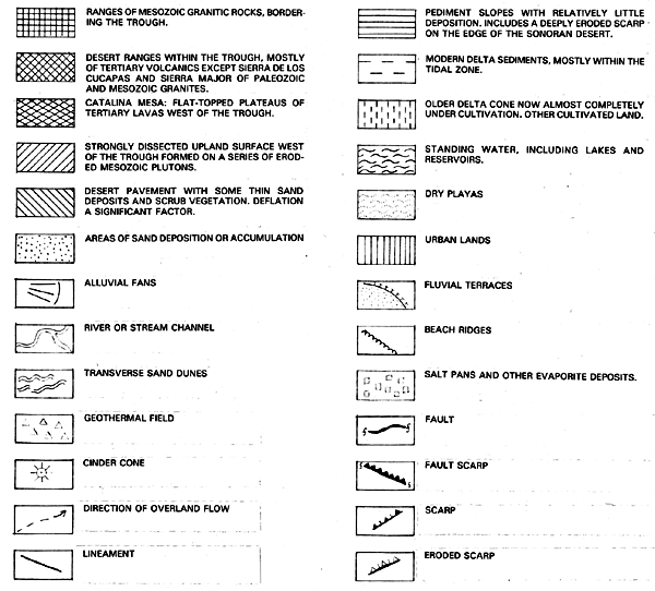 |
|---|
Coastlines to either side of the modern delta appear to be undergoing active marine erosion. The scalloped appearance of the coast of the Sonoran Mesa south of the delta is indicative of active erosion, as is the arcuate character of the coastline east of the Sierra San Felipe. Thompson (1968) says that recent coastal erosion has removed most of the sediments on the seaward side of the easternmost San Felipe peaks, although their former presence is attested to by a distinctive rim of mud, capped by alluvial gravels, along the edge of the peak.
There are several strong indications of the influence of human activity on the geomorphology of the delta. The older delta cone, which was, under natural conditions, a desert, is now almost entirely under cultivation. One of the most obvious results of human activity is the manifestly underfit character of the present river in relation to its delta. A large portion of the natural flow of the river is now diverted to areas outside the Colorado basin from locations upstream. In addition, most of the river´s sediment load has been trapped upstream in Lake Meade since 1935. Even though effects of continued sediment deprivation cannot be evaluated from a single scene, the sequential analysis of the same scene over several years should reveal changes in the delta due to tidal erosion.
At smaller scales, covering larger areas, regional geomorphic systems can be seen as subsystems nested into one or more larger regional systems of differing geomorphological character. The complexity of the Colorado Delta region is due, in part, to its location at the intersection of two larger geomorphic systems, each controlled by a different mix of geomorphological processes. It is a nested subregion of the Colorado River Drainage Basin, a fluvial system in a predominantly mountainous setting, and of the Gulf of California, an active tectonic system in a largely marine environment.
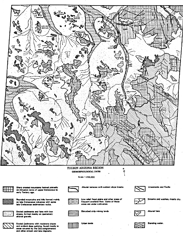 |
Figure 11.9. Geomorphological units of the Tucson, Arizona, region drawn from a Landsat Thematic Mapper image. The original scale of the map is 1:250000. |
|---|
Few, if any, geomorphic systems exist in isolation. Even such seemingly isolated regions as the Hawaiian Islands do not stand alone. They are bound into the tectonic processes of the Pacific Ocean Basin and are influenced by midocean marine processes and subtropical climate.
GEOMORPHOLOGICAL MAPPING OF THE TUCSON AREA
A geomorphological map of the area from Tucson, Arizona, southward past Nogales into northern Mexico and westward by about 100 miles was developed from a Landsat 4 Thematic Mapper (TM) scene obtained on January 8, 1983 (Figure 11-9). The original map was produced by photointerpretation techniques on a scale of 1:250 000 using black and white images of bands 3, 5, 6, and 7 and a color image composite from bands 2, 3, and 4 (see Plate F-9). Other sources used in this mapping were the U.S. Geological Survey (USGS) 1:250 000 topographic sheets of the area, used principally to identify the names of places and features, and a geologic map of the state of Arizona used to identify the lithology. The symbols used on the map were generally taken from the ITC system for Geomorphological Survey, and contrasting geometric patterns were used to display different geomorphological units. Again, the map was not checked out in the field. Before this or any other geomorphic units map produced by remote sensing techniques is used for definitive research, it should be field-checked for accuracy.
Band 7, in the shortwave infrared range, was used to draw the basic map as it was judged to provide the clearest definition of various geomorphic features. Images from the other bands and the color composite were used for comparison to refine the definition of various mapped features. Drainage features were quite clear on all bands, although band 6, even with its lower (120 m) resolution, better highlighted the master channels of the area. This was helpful in deciding how much of the drainage pattern to map in an area laced with a fine network of ephemeral channels. Band 6, in the thermal infrared region of the spectrum, was also particularly useful in defining breaks in slope indicating the division between mountain and pediment features. Cultural features, including urban and agricultural areas and strip mines, showed most clearly on the color-composite image.
| Figure 11.10. False-color composite Landsat Thematic Mapper image subscene of Tucson, Arizona, and invirons. | 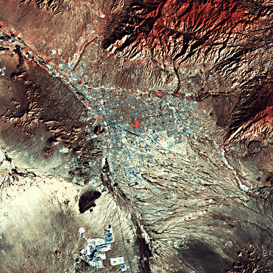 |
|---|
Tucson is located in the Basin and Range Physiographic Province, a large region covering much of the southwestern United States and parts of northern Mexico. The province is characterized by numerous small linear ranges of block-faulted mountains separated by low pediments and playas. In this scene, two types of mountain ranges are evident. Most of the ranges are sharp-crested mountains of mixed lithology but composed primarily of Cretaceous to Early Tertiary crystalline rocks. These are interspersed with some Paleozoic and Precambrian units and some segments of Middle Tertiary volcanics. The other mountain ranges have rounded crests and are composed mostly of Middle Tertiary volcanics. The difference between the two types of mountain ranges shows up quite clearly on the imagery. The two different types of mountains can be clearly identified on the Tucson city subscene (Figure 11-10). The Santa Catalina Mountains in the upper right-hand portion of the subscene are sharp-crested mountains (recently classed as a metamorphic core complex) composed of mostly Cretaceous crystalline rocks with some Paleozoic units. Black Mountain southwest of Tucson is a prominent, relatively low rounded mountain formed of Middle Tertiary volcanics. The Tucson Mountains west of the city are of mixed lithology with the central core formed on crystalline rocks and the northward extension of the Tertiary volcanics. Lithological differences would require field work for identification, but the geomorphological distinctions between the two types of lithology can be distinguished on the imagery.
In addition to the two dominant types of mountains, there are also several small ranges of folded sedimentary rocks in the western portion of the general scene. Alluvial fans and terraces were mapped wherever there appeared to be an obvious slope break. Some of the terraces and pediment fans are especially large, particularly north of Tucson against the Santa Catalina Mountains and along the Canada del Oro. An exhumed bedrock pediment borders the Santa Catalina Mountains along the east side of the Canada del Oro (Figure 11-11). This shows up very clearly on the Tucson subscene. Within the scene are two distinctly different areas that may be parts of separate subregions within the Basin and Range Province. South and east of the Empire, Santa Rita, and Tumacacori Ranges, the mountains are quite close together, and the pediments between them appear to have relatively steep slopes dominated by active gullying into the Gila Conglomerate that forms the cover in this area. The valley bottoms appear to contain relatively little alluvium. The boundary of this area closely coincides with the western boundary of the section of the Basin and Range Province that Fenneman (1931, page 380) titled "The Mexican Highland."
| Figure 11.11. Oblique aerial photograph taken near Tucson, Arizona, looking west from the Canada del Oro along an exhumed bedrock pediment at the foot of the Santa Catalina Mountains. Note stream terraces. Photograph by Peter Kresan. |  |
|---|
Throughout the remainder of the scene, the mountains are more widely spaced and are separated by pediments with low slopes and considerable alluvial fill. Wide drywashes characterize the valley bottoms. Low-relief floodplains were mapped along the sides of the Santa Cruz River and some other areas identified by a greater concentration of vegetation. These were also the areas containing agricultural development. Lineaments were mapped where evident on the scene. Some of these lineaments probably represent fault traces, but none were mapped as faults because evidence of displacement could not be resolved on the imagery. There are two quite prominent Quaternary fault scarps cutting across the Madera Canyon alluvial fan, a prominent feature extending northwestward from the Santa Rita Mountains southeast of Green Valley. These scarps are visible on an aerial photograph (Figure 11-12), but cannot be detected on the Landsat image. It is possible that, on another image of the area taken at a different time with a different Sun angle, these fault scarps might show up.
 |
Figure 11.12. Oblique aerial photograph looking southeast at the Madeira Canyon alluvial fan south of Tucson, Arizona. Photograph by Peter Kresan. |
|---|
The geomorphology of the Tucson/Nogales area is much less diverse than that of the Colorado Delta region. However, this area also has its own complexity. Mapping the area from satellite imagery displays the boundary between two sections of the Basin and Range Province better than Fenneman could ever have hoped and clearly shows a significant part of the uniformity and the diversity of process and form that characterize the region.
Geomorphological processes seldom "sit for portraits." They can be best studied through their resulting landforms. At small-scale regional levels, landform patterns and distribution are surrogates through which the integration of many geomorphological processes can be studied. Regional geomorphological mapping from space imagery promises to become a powerful tool for the study. Space imagery is limited by scale and resolution in the amount of detailed information it can provide. As resolution is improved and new techniques, such as stereoscopic viewing, become available, space imagery will yield more information about particular locations. The small-scale and large-areal coverage of space imagery is one of its principal advantages. The primary value of space imagery for geomorphology lies not in the amount of detail it reveals, but in the broad perspective of regions of the Earth´s surface it provides. A regional geomorphology based on this broad perspective is a needed complement to detailed geomorphology focused on particular landforms and landform types, dominated by often diverse processes within relatively limited areas. Such a regional geomorphology should be concerned not with the multiplication of detail, but with the multiplicity of processes that, acting together, give each landform and each landform region its uniqueness. Space imagery offers the synoptic overview, and regional geomorphological mapping provides the technique by which geomorphologists can investigate the complex interactions of geomorphic processes that have formed and are modifying the dynamic surface of the Earth.
Continue to Chapter 11 References| Return to Home Page| Complete Table of Contents|