| Figure 2.1. Map of global tectonic and volcanic activity of the last one million years (Lowman, pers. comm.). The map provides a current tectonic context for the Plates in this chapter. | 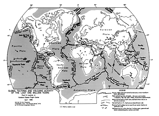 |
|---|
W. M. Davis (1899) viewed structure, process, and time as the three pillars of geomorphology. Although there has been great progress in geomorphology since the fundamental work of Davis, his "trio" of structure, process, and time (stage) remains a useful starting point for any treatment of landforms, be they earthbound or extraterrestrial. Structure is generally agreed to be the most important of the Davisian trio. "Structure," as used by Davis and most later geomorphologists (e.g., Thornbury, 1969), includes not only deformational features like folds, faults, and joints, but any characteristics of the rock bodies such as their mineralogy and fabric that govern their relative resistance to erosion. In this chapter, we normally use "structure" in its deformational or tectonic sense.
One of the most profound realizations after looking at the Earth from space, where vast areas are seen in a single image, is that, over much of the land surface, the major control of the landscape is its underlying structure (Wolman, in preparation). From the vantage point of space, one seems to "see through" the modifying effects of process and stage to reveal this intrinsic control. The role of process and stage is more obvious at local scales. The synoptic views of tectonic landforms presented in this chapter offer strong support of the concept that, in the Davisian trio, structure is the "first among equals."
"Tectonic landforms" are structural landforms of regional extent. These landforms make up extensive landscapes whose topography is strongly influenced by the structure of underlying rocks that have undergone (or are undergoing) some degree of deformation (and possible associated metamorphism and igneous intrusion). Landscapes developed on orogenic belts, uplifts, domes, basins, and shields can all be thought of as tectonic landforms. There is a continuum of tectonic landforms ranging from recently formed fault scarps to physiographic provinces (e.g., Valley and Ridge Province of the Appalachian orogen) that have evolved over many millions of years by differential erosion on older structures that themselves took millions of years to form. Bloom (1969) points out that one rarely sees pristine tectonic landforms (i.e., those surface features formed solely by crustal deformation such as fault scarps) because they are constantly being modified by erosion as deformation proceeds so that their shapes originate both by endogenetic and exogenetic processes.
A minor problem in categorization arises in connection with landforms cut on nearly horizontal, essentially undeformed strata where uplift and erosion have combined to create substantial and often spectacular relief. The Colorado Plateau and the Grand Canyon are obvious examples, but the midcontinent region of the United States and the Siberian Platform also fall into this category. In many such areas, fractures or other structural features control or strongly influence erosion, so that the term "structural geomorphology" (Bloom, 1978) can be appropriately applied. Degree of deformation in this definition is incidental.
The organization of the gallery sections of this book, in which chapters are based on geomorphic process (e.g., glacial, eolian, and volcanic), tends to obscure the fact that almost every. large region has been shaped by many processes, in most instances operating through several geomorphic cycles, all controlled by structure. Chapter titles are thus pragmatic categories that do not necessarily represent the actual evolution of the landscapes shown. A physiographic province such as the Canadian Shield is thus a sort of palimpsest or montage, in which "complexity of geomorphic evolution is more common than simplicity" (Thornbury, 1969). Physiographic provinces are a useful means of grouping regional landforms; Fenneman's physiographic maps, for example, although dating from the 1920s, are still basically valid.
Geomorphic classifications of structural features at local scales are uncommon, and regional scale classifications (beyond the physiographic province concept) apparently do not exist (C. D. Oilier, Australian National University, personal communication). A search of the literature (Bloom, 1978; Butzer, 1976; Chorley et al., 1985; King, 1967; Morisawa and Hack, 1984; Oilier, 1981; Small, 1978; Sparks, 1972; Twidale, 1971, 1976) reveals several possible reasons for this situation.
For tectonic (and volcanic) landforms, the materials, processes, and subsurface geometry are mainly endogenic and three-dimensional. In contrast, landforms related to fluvial, eolian, and other processes are primarily exogenic and essentially two-dimensional. These same processes, of course, etch out features established by endogenic processes. The point is that, although a large collection of specific classes and descriptive terms exist for exogenic landforms, there is no comparable vocabulary for endogenic ones. Instead, much terminology for these landforms is adapted from that used for them in a structural (or volcanic) sense. Thus, such terms as anticline, thrust sheet, fault, and nappe (or stratocone, caldera, and shield volcano) are used interchangeably between endogenic structures and associated landforms. Some structural terms are used with modifiers (e.g., breached anticline, anticlinal ridge, perched syncline, and faultline scarp) to clarify particular geomorphic aspects. Other terms such as cuesta, hogback, inselberg, mesa, ribbed ridge, and stream offset are geomorphic but have structural connotations.
Because of these problems in classification and nomenclature, the text for Plates in this chapter and the next (volcanic landforms) may appear to neglect the geomorphic aspects of the chapter themes in that structural and volcanic terms are applied to landform description. The situation is aggravated, paradoxically, by the main advantage of orbital remote sensing- its wide areal coverage -that inherently best shows the very large features for which terminology and classification are generally lacking.
Earth scientists received their first glimpses of the Earth from space in photographs from sounding rockets and early manned missions in the early 1960s (Lowman, 1985) at about the same time that interest blossomed in seafloor spreading and what became known as plate tectonics. Thus, a new paradigm and the tools for studying that paradigm fortuitously emerged at about the same time. Since 1972, the high-resolution (79 m), nearly global Landsat imagery has had a great impact on the scientific understanding of the geology of isolated, poorly mapped land areas (e.g., the African Rift, studied by Mohr(1973) with Landsat data). Weather satellites, the Heat Capacity Mapping Mission, Seasat radar, and Shuttle Imaging Radar (SIR-A and B) have provided additional means for refining and integrating the regional perspective, although Landsat remains the most widely used comprehensive space data set for the Earth sciences. Lowman (1981) used Landsat and manned mission imagery, along with published maps, to compile a map of global tectonic and volcanic activity during the last 1 Ma (Figure 2-1) that is a useful framework for the geotectonic applications of orbital imagery discussed in this chapter.
| Figure 2.1. Map of global tectonic and volcanic activity of the last one million years (Lowman, pers. comm.). The map provides a current tectonic context for the Plates in this chapter. | |
|---|
The work of Molnar and Tapponier (1975) and Tapponier and Molnar (1976, 1977, 1979) powerfully demonstrates the value of space-acquired data for regional tectonic studies (Tapponier et al., 1982). Using Landsat imagery together with existing geologic information and seismic data, they reinterpreted the recent tectonics of China in terms of the collision of India with Eurasia (Figure 2-2). What emerged is a new insight into the extremely widespread structural consequences of continent/continent plate collisions. An integrated pattern of fold and thrust belts, strike-slip faults, and grabens is spread over much of south-central and eastern Asia. Many features mapped by these workers (largely based on geomorphic interpretation of Landsat images) were recognized for the first time as major tectonic elements. Geomorphic features and tectonic modeling implied displacements on faults of magnitudes that have since been confirmed in several areas by field work (W.S. F. Kidd, personal communication, 1985). This series of Landsat investigations is a tour de force of interpretation, tectonic modeling, and regional synthesis.
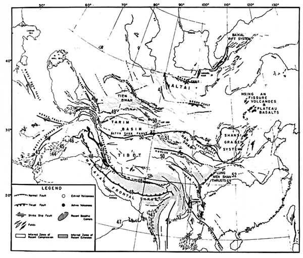 |
Figure 2.2. Map of the major structural features related to the collision of India with Eurasia during the Tertiary (Molnar and Tapponnier, 1975). The map is based on the analysis of Landsat imagery and available geological and geophysical data. Numbers indicate areas covered by Plates in this Chapter. |
|---|
Plate-tectonic theory provides a conceptual framework within which to examine tectonic landforms. Stress fields, resultant strain fields, and regional deformation patterns reflect the plate-tectonic setting in which they formed. Tectonic landforms visible on space imagery can thus aid in deciphering the structural history of an area in context with adjacent areas. In examining the Plates comprising this chapter, it will be helpful to associate landforms with a plate-tectonic setting (Table 2-l).
| A. | Divergent plate boundaries (plates moving away from each other with creation of new lithosphere) | |
| 1. | Intracontinental rifts (T-37) | |
| 2. | Oceanic spreading centers (V-13) | |
| 3. | Trailing continental margins (C-4; T-37) | |
| 4. | Failed rifts (aulacogens) (V-2) | |
| B. | Convergent plate boundaries (plates moving toward each other with consumption of lithosphere) | |
| 1. | Ocean/ocean (V-9) | |
| 2. | Ocean/continent (T-58) | |
| 3. | Continent/continent (T-43) | |
| 4. | Accreted margins (T-9) | |
| C. | Transform zones or shear plate boundaries (plates slide past each other; lithosphere is conserved) | |
| 1. | Trench/trench (T-39) | |
| 2. | Ridge/trench (T-43) | |
| 3. | Ridge/ridge (T-3) | |
| D. | Plate interior settings | |
| 1. | Ancient metamorphic terranes (shields) (T-59) | |
| 2. | Flat-lying sediments overlying stable craton (F-10) | |
| 3. | Intracratonic uplifts (T-7) | |
| 4. | Posttectonic magnatic intrusions (T-60) | |
| 5. | Normal faults related to "downslope" gravity sliding of uncompated sediments (D-1) | |
| 6. | Evaporite deapirs (T-42) | |
| 7. | Hotspot tracts and aseismic ridges (V-10) | |
| 8. | Submerged continent fragments- | |
| 9. | Anomalous uplift of extant deformation belts (T-21) | |
| 10. | Intraplate faulting related to reactivation of ancient fault zones (T-23) | |
| 11. | Dike swarms and related fractures (T-17) | |
Although tectonic setting is a recurrent theme in the description of the images, it serves better as a context for discussion than as a basis for classification of tectonic landforms. Superficially similar deformation packages may have formed in different tectonic settings. The sequence of structural overprinting in many areas is difficult or impossible to determine from morphology alone. Consequently, in some instances, knowledge of deformational and depositional events is necessary to infer plate motion history. Some plate settings are not associated with unique or spectacular structures (e.g., passive continental margins). Others are covered with water; midocean ridges, submerged continental fragments, and subduction zones. Still others, such as convergent plate boundaries, hotspot tracks, and midcontinent rift zones, are expressed as volcanic landforms, which are covered in Chapter 3.
Most of the landforms depicted in this chapter were formed primarily by differential erosion acting on structures produced by endogenic processes. Although there are variations due to climate and previous erosional history (including different processes, rejuvenation, earlier planation, etc.), tectonic landforms in different parts of the world have enough in common to be recognized as variations on several common themes. Thus, the Flinders Range of Australia (desert), the Ouachita Mountains of Arkansas (humid and forested), and the Labrador Trough (glaciated) are all clearly fold belts. The essential control of tectonic landforms is tectonic history, including cycles of sedimentation, deformation, and igneous or metamorphic events. For this reason, commentaries on the Plates in this chapter (and most of the references cited) tend to stress the tectonic regimes depicted rather than geomorphic processes.
The space-acquired images in this chapter display a variety of tectonic features distributed over six continents. After reviewing many examples of different types of space imagery from many sources, we based our selection on several criteria that sometimes conflicted. An obvious goal was to display a diversity of tectonic provinces and structural styles, and images that boldly portrayed geomorphic/tectonic features in an instructive manner were preferred. Although we sought a diversity of tectonic styles and settings, some important but bland or nonphotogenic settings (e.g., stable sediment-covered cratonic interiors) are underrepresented, whereas tectonic "spectaculars" such as shields and fold belts may be overemphasized. In addition to diversity, we attempted to use examples from many parts of the world, including those regions important in the development of fundamental insights and basic principles of geology and geomorphology. We realize that areas within optimum viewing environments, such as deserts and semiarid regions, get more attention than those in high or low latitudes where cloud cover and vegetation pose problems. Our own experience colored our choices; other workers would have made different and equally valid selections in attempting to strike a three-way balance among aesthetics, diversity, and scientific interest.
In the interest of space and ease of reading, we have kept citations within the text to a minimum. The references in the text and the list are far from exhaustive and are meant to provide a point of entry into the literature rather than comprehensive documentation.
The Plates in this chapter are arranged geographically rather than by tectonic style, partly to avoid surfeiting the reader with a repetitive sequence of the same theme (e.g., a half dozen shield scenes in a row). Because the continents themselves are products of large-scale tectonic processes, the continent by continent grouping establishes a coherent thread that connects and relates many of the tectonic features in a given region. For example, the closing of the Tethys Sea as several crustal plates collided provides a large number of our examples that sprawl from the Anti Atlas through the Alps, the Anatolides, and the Zagros to the Himalaya Mountains.
The deformation field produced by the Indian plate as it impinges on the Eurasian plate offers several striking examples of tectonic landforms. This region contains excellent examples of many of the different tectonic styles associated with a single type of plate interaction-continent/continent collision. Deformation styles include compressional folds and thrust faults of the frontal Himalayas, ridge-trench transform (strike-slip) faults (Chaman/Quetta Fault), large-scale strike-slip faults (e.g., Altyn Tagh and Kunlun Fault), and tensile regions like the Shanxi Graben system. The magnitude and recency of the Indian collision event, coupled with the climate of the area, make the images of this area particularly spectacular.
The Appalachian images, from New England to Georgia and Oklahoma, reveal the anatomy of a fold belt produced by periodic accretionary collisions, culminating in a continentwide convergent collision. Previously existing geologic structures and differences in depositional history along the system produce a variety of features that are characteristic of large-scale continent/continent convergence and whose recognition may be useful in the study of other similar systems.
Western North America was an area of plate convergence throughout most of Mesozoic and Early Tertiary time. About 30 Ma B.P., a segment of the East Pacific Rise, the spreading enter that had driven plate convergence against the west coast, began to impinge on the subduction zone that lay along the west coast. As portions of the spreading center were subducted, a ridge/ridge transform fault gradually developed, linking the ends of the surviving sections of the East Pacific Rise (Atwater, 1970). The American and the Pacific plates began to slide past each other, changing the ambient stress field from one of convergence-driven compression to right-lateral shear. The consequences of both these large-scale stress fields extend far beyond the immediate zone of plate interaction and are evident in the structure and resulting geomorphology of the region. Images covering a few to many thousands of square kilometers shed light on this complex story.
The series of illustrations dealing with the African Rift, Afar Triangle, Gulf of Suez, etc. offer insight into the initiation of rifting, continental breakup, and separation. The geologic record preserves a number of these features, frozen in various stages of development. It is clear that few rifts grow large enough to become oceans and that a host of events can interrupt the process, some forming failed rifts or aulacogens (Burke, 1977). Study of these features provides a better comprehension of the early genesis of oceans and rifted continental margins.
A fascinating aspect of this chapter as a whole is the recurrence of certain tectonic/geomorphologic motifs. Shield areas in Canada, Brazil, India, Australia, and Africa have a surprising number of features in common. The whaleback folds of the southern Zagros of Iran are morphologically similar to the dècollement folds of the Sichuan Basin of China, despite notable differences in the climate, tectonic setting, and ages of the rocks involved. The same is true for the Shanxi Grabens of northeast China and those of the Basin and Range Province of the western United States or the folds of the Atlas Mountains of North Africa and the Appalachians of eastern North America. These similarities can be both informative and deceptive. They enable us to extrapolate insights gained from well-studied to less-studied areas. In some instances, of course, apparent similarities may mask critical differences. This points up some of the benefits and pitfalls of using space imagery to efficiently interrelate widely separated features and the critical role of field work.
Another informative aspect of viewing geomorphology globally is the wide distribution of features that are believed to be unusual or rare. Large strike-slip faults control topography over vast areas of China, the west coast of the United States, and the Levant. Alluvial fans, some astoundingly large, are common, widely distributed landforms. This suggests that a considerable amount of insight is to be gained from studying the Earth in a holistic way similar to the global-scale exploration of a growing number of extraterrestrial bodies by deep space probes.
Few Plates in this chapter deal solely with a single tectonic or geomorphic process. This substantiates the increased scope that synoptic observations from space bring to the geosciences; at the regional level even more than locally, the concern must be with intricate patterns of surface and subsurface features wrought by a variety of processes acting serially and in concert. Geomorphologists are still developing appropriate descriptive and analytical tools to handle the wealth of new information about our planet returned from an increasing number of space systems (see in particular Chapter 12 and Appendix A). What will be learned promises to broaden, improve, and almost certainly alter the conceptual framework from which major paradigms in geomorphology specifically and geology in general will continue to evolve.
In addition to the expressions of gratitude given in the Acknowledgment section at the beginning of this book, the authors wish to call special attention to certain individuals who offered invaluable assistance in the preparation of this chapter.
The authors of this chapter shared the work of assembling the imagery and preparing the text. Two of them, J. R. Everett and N. M. Short, are identified at the end of the text by initials (JRE) and (NMS) as responsible for organizing most of the Plates and their written material; guest caption writers are identified by name at the close of the text they developed and again in Appendix B, along with their addresses. Marie Morisawa played a special role throughout this chapter by reviewing and editing the text of all Plates and has infused geomorphic observations into this text wherever the other authors "leaned too far" toward the purely tectonic aspects of a scene. Paul D. Lowman, Jr., of NASA/Goddard Space Flight Center, was instrumental in refocusing the emphasis and approach initially chosen for the chapter introduction, several sections of which are incorporated as he rewrote them.
Members of Paul Lowman's Structural Geology class (Spring 1984) at the University of Maryland participated in a term project designed to help themselves in the learning process, as well as to assist us at a critical time during the early preparation of the commentaries. Each student was assigned to analyze one of the candidate tectonic landform images and to summarize the results in a report that included illustrations and references. These contributors are listed in Appendix B.
A turning point in our conception of this chapter arose from an insightful critique of the first full draft by Kevin Burke of the Lunar and Planetary Institute. It was he, more that anyone, who led us to realize that this chapter not only comprises a comprehensive survey of tectonic landforms per se but also is, in a sense, a summary of the geology of the entire Earth insofar as that depends on the nature and distribution of orogenic belts and shields as framework.
Finally, especially deserving of thanks are members of the Earth Satellite Corporation for their assistance, in particular, Max Miller and others in the Photolab, Coetta Withgott and her word-processing crew, and Fanny Barrett for her patience in coordinating preparation of the captions through several rewrites.