 |
 |
|---|---|
| Plate T-10 | Map |
|
|
|---|---|
| Plate T-10 | Map |
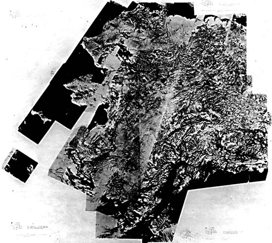
This mosaic of Landsat MSS images covers some 1.5 million km2, providing a view of most of the state of Alaska that would have been almost impossible to obtain before the availability of space imagery. Changes in geomorphic character differentiate the various geologic provinces (Thornbury, 1965, Ch. 28). Some of these geologic provinces have counterparts in the Canadian and U.S. Cordillera. The rugged Pacific Border Ranges (highest peaks >6000 m) consist of the St. Elias Range (southeast of the mosaic) and the Chugach Mountains, farther west. They are a continuation of the Coast Ranges of British Columbia, Washington, and Oregon. The arcuate (convex north) Alaska Range and the Talkeetna and Wrangell Mountains are considered correlative of the Cascades/Sierra Nevadas in the United States. The interior Alaska lowlands and highlands, drained by the Yukon/Tanana/Porcupine River system and characterized by downfaulted troughs containing Eocene and younger sediments, correspond somewhat to the Basin and Range province. The Brooks Range is analogous to the Rocky Mountains, and the North Slope is comparable to the western Great Plains.
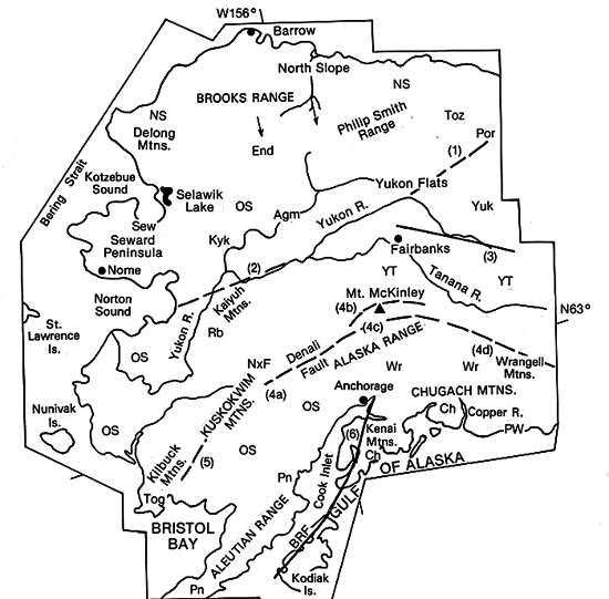
Prominent right-lateral wrench faults and the juxtaposition of rock units quite different in lithology, age, and origin suggest that far-traveled allochthonous terranes make up the bulk of Alaska and the adjoining Cordillera of Canada (Jones et al., 1982; Monger and Price, 1979; Jones and Silberling, 1979). Generalized locations of most of the larger recognized and named terranes are set forth on the index map, as indicated by the following abbreviations: AGM = Angayucham, Ch = Chugach, End = Endicott, Kyk = Koyukuk, NXF = Nixon Fort, OS = Overlap Sequence ("hiding" subjacent terranes), PN = Peninsular, POR = Porcupine, PW = Prince William, RB = Ruby, SEW = Seward, TOG = Togiak, TOZ = Tozina, WR = Wrangellia, YT =Yukon/Tanana, and Y = Yukon. The only autochthonous part of Alaska, which has remained part of North America since the Precambrian, is a small triangular area in the northeast corner of the state. This area, the Yukon Flats, is bounded by both the Yukon and Porcupine Rivers and is centered around the Fort Yukon area. The rest of Alaska, including the highly deformed Brooks Ranges, has moved to some extent, although the amount, nature, and timing of movement is poorly understood and highly controversial. Marked paleontological and stratigraphic discontinuities, coupled with paleomagnetic studies, indicate that most Mesozoic rocks now in Alaska originally formed at more southerly latitudes (Jones and Silberling, 1979).
Hallmarks of the Alaskan tectonic regime are the several major strike-slip faults that roughly parallel the principal mountain chains (Lathram et al., 1974). These faults, plotted on the index map by number, are: (1) Yukon Flats fault. (2) Kaltag (RL (right lateral)), (3) Tintina (RL), (4) Denali system (RL): 4a = Farewell, 4b = Hines Creek, 4C = McKinley, 4d = Shakwak Valley segments, (5) Togiak/Tikchik (RL and reverse), (6) Border Ranges (RL and reverse), (7) Fairweather (RL), and (8) Chugach/St. Elias fault. Several are visible in the Landsat mosaic. The Border Ranges fault defines the western front of the Kenai Mountains, where these rise more than 1300 m (Figure T-10.1) from the downdropped coastal plains (MacKevett and Plafker, 1974).
| Figure T-10.1 | Figure T-10.2 |
|---|---|
 |
 |
After earlier orogenic events in the Jurassic, climax deformation of the Brooks Range occurred in the Cretaceous, with strong northward thrusting of thin-skinned tectonic displacements. More orogenic activity took place in the Late Tertiary and Quaternary, further distorting the range to its present concave northward bend. The Brooks Range contains both open and tight folds; it now rises to altitudes of almost 3000 m and displays a moderately rugged topography accentuated by glaciation. The Foothills (400 to 1000 m high) to its north are underlain by Devonian to Cretaceous sediments and mantled by Pleistocene morainal deposits.
The Yukon/Tanana Uplands consist of moderately folded Paleozoic/Mesozoic sedimentary units and a distinct east-central metamorphic zone. Dissected plateaus are present. The Tintina Trench, a possible extension of the Rocky Mountain Trench (Plate T-9), divides the Uplands from the Yukon Flats Lowlands underlain by highly folded Mesozoic units. To the west, a vast region of alternating highlands (Kuskokwim, Norton Sound, and Seward) and lowlands are built of Late Paleozoic through Tertiary metamorphic sedimentary and volcanic rocks and Quaternary continental beds.
| Figure T-10.3 | Figure T-10.4 |
|---|---|
 |
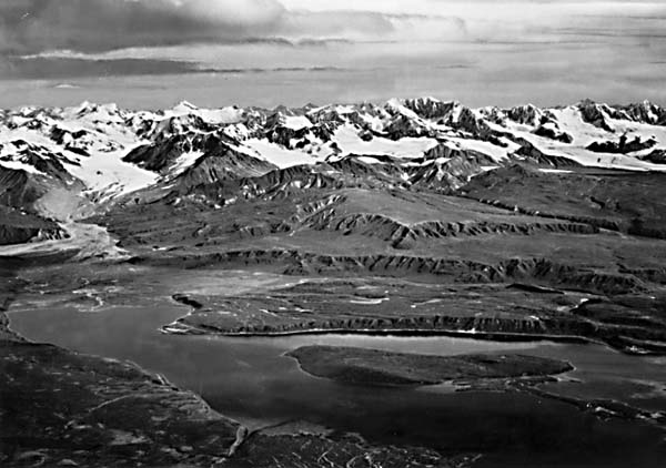 |
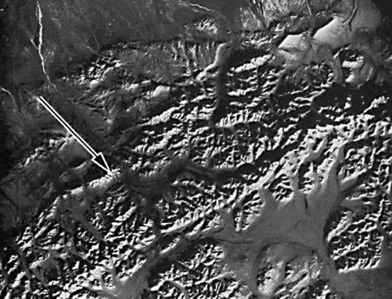
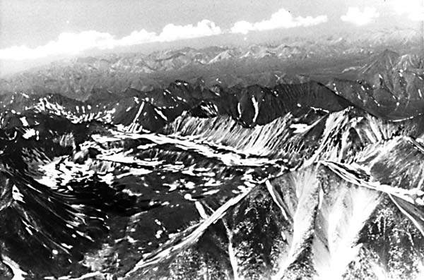
Most of southern Alaska is characterized by narrow arcuate zones of strongly folded and faulted metamorphic and intrusive rocks and zones of compressed strata, much of whose structure is mainly the result of subduction. The Alaska Range is a large synclinorium of uplifted rocks cut by numerous faults, accentuated by active glaciers. Most of its peaks are under 4000 m, but Mt. McKinley reaches 6194 m. A Landsat image (Figure T-10.2) includes Mt. McKinley (arrow) and the south-facing mountain front along the arcuate Denali strike-slip fault (Figure T-10.3). Triangular facets are prominently displayed along the scarp face at interfluves. Volcanic rocks make up much of the Wrangell Mountains to the southeast. (Mt. Wrangell is an active volcano.) The Alaska Peninsula and Aleutian arc (Plate V-9), a line of active arc-continent collision, also include many volcanoes (more than 80: 36 active, 20 forming calderas). The Chugach Mountains along the Gulf of Alaska exceed 4000 m in altitude inland, with spectacular scenery created by the intense sculpturing of Pleistocene and modern glaciers (Figure T-10.4). (NMS) Additional Reference: Williams (1958). Landsat Mosaic.
Continue to Plate T-11| Chapter 2 Table of Contents| Return to Home Page| Complete Table of Contents