 |
 |
|---|---|
| Plate T-12 | Map |
|
|
|---|---|
| Plate T-12 | Map |
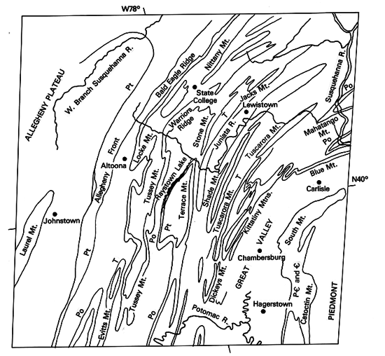
The mental picture of the Appalachian Mountains most of us have is that of long linear ridges and valleys that form a belt some 25 to 100 km wide through Pennsylvania/Virginia/West Virginia and the Carolinas. With relief of 300 to 1000 m or more, these ridges stand out as mountains, particularly obvious where they must be crossed by car on older highways. On a trip across the belt along the Pennsylvania Turnpike and other Interstates, one can observe the structural forms that have made the Valley and Ridge Province of the Appalachians synonymous with folded mountains. Outcrops almost invariably consist of inclined Paleozoic strata. Individual ridges may show reversal of dip, usually associated with secondary or smaller scale folding, but more commonly, the dips in a given ridge are essentially homoclinal, comprising only one limb of a larger anticline or syncline. The exact nature of the structure must usually be inferred or reconstructed by examining the stratigraphic sequence and bedding attitudes in successive ridges.
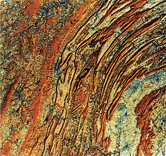
The Plate covers the well-exposed central Pennsylvania segment of the Valley and Ridge Province of the Appalachians. This foreland province, wedged between the Piedmont/Blue Ridge Provinces and composed of strongly metamorphosed rocks on the east and the uplifted but only mildly deformed sediments of the Appalachian Plateau on the west, runs the length of the Appalachian orogen from northern New York to Alabama. Within the belt, exposed rocks generally become increasingly older from west to east, but age discontinuities exist in parts of the belt because of complex thrusting and differential erosion. In the sections exposed in Pennsylvania, there are fewer thrusts than in the southern Appalachians and the southern end of the central Appalachians around Roanoke, Virginia (see Figure T-11.5). To the northeast, the diagnostic fold forms of the Valley and Ridge Province diminish rapidly in the vicinity of the Pocono Mountains of Pennsylvania and Catskills of New York (Plate T-11). A structural style similar to the folded Appalachians has developed along the Hudson-Champlain valleys, with differential erosion forming the "Little Folded Mountains," or Helderbergs, with the characteristic linear ridge forms.
Plate T-12 illustrates beautifully the effects of fluvial erosion on strata of unequal resistance that have been folded by continental collision. The long linear monoclinal ridges, held up by resistant sandstones and conglomerates, become zig-zag mountains as they wind around plunging fold noses; the short stubby zags are canoe-shaped synclinal noses, and the long gentle cigar-like noses are anticlines. The major ridge makers are the Tuscarora (T), Pocono (Po), and Pottsville (Pt) Formations. Benches (subsidiary ridges) can be seen on the inner sides of the main outlining ridge in anticlinal structures and on the outside in synclines. Most ridges are monoclinal, and the dip of many can be determined by the difference in scarp and dip slopes. However, at many locations, strata dip so steeply that slopes on both sides of the crest are equal. The grain of the ridges makes it obvious that folding is much tighter on the east side of the province and broader and more open to the west. Offsets of some ridges indicate cross faults.
Nittany Valley and Morrison Cove, eroded anticlinal valleys (coves), near the western edge of the fold belt shown here, and Broadtop Mountain (a syncline east of Morrison Cove) are examples of inverse topography, which is common in this geomorphic province. Anticlines became breached, and the overlying sediments eroded down to the weak Cambrian/Ordovician carbonate strata, forming valleys. Synclinal structures, protected by the resistant Pottsville and Pocono Formations, become higher as less resistant rocks are eroded away around them.
| Figure T-12.1 | Figure T-12.2 |
|---|---|
 |
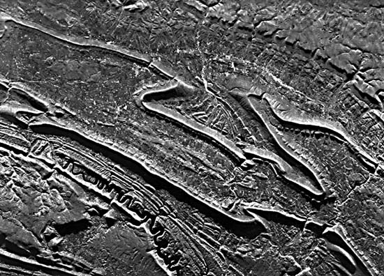 |
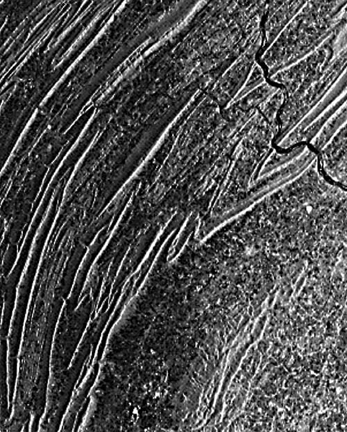
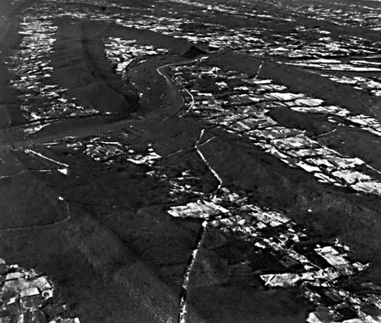
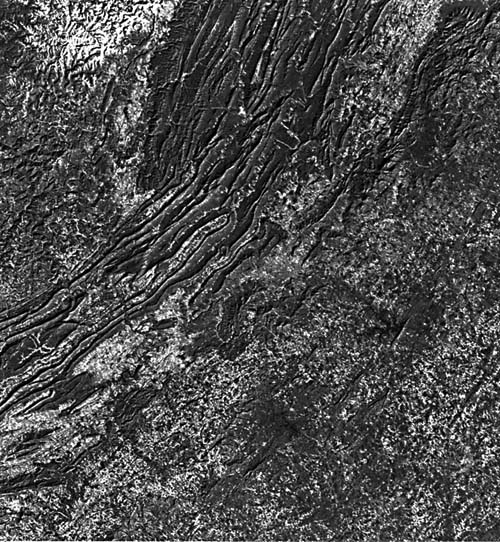
The overall trellis drainage pattern can be traced by careful scrutiny of the Plate and of a Seasat SAR image (Figure T-12.1, near Harrisburg) and an aircraft radar (X-band) image (Figure T-12.2, near Altoona), shown together for comparison. One of the major geomorphic problems of the folded Appalachians is the anomalous drainage, with transverse streams flowing across the structure, creating wind and water gaps. The Susquehanna River, the major river in the Plate and Figure T-12.1 seems to pay very little attention to structure and cuts right across major ridge-forming strata. However, note that the river does dodge around or cut close to the end of plunging noses as it makes its way southward (Figure T-12.3). In places, its major tributary, the Juniata, does the same. Both the Juniata and the Susquehanna are partially subsequent where they flow along strike valleys (oriented northeast-southwest). Moreover, it is also possible that the rivers are subsequent where they cut across a resistant ridge in a water gap. There are cross faults (offsets in the ridges), and the river may have discovered and utilized this weakness in carving its channel. In other places, the river channel may have been locally superimposed onto the underlying stratum. Another possibility is that the major southeast-flowing rivers were all superimposed from a regional coastal plain cover that extended westward (to the Appalachian Plateau?).
| Figure T-12.3 |
|---|
 |
Another long-standing problem of the folded Appalachians is the origin of the accordant ridge summits and their evenness over long distances. Do these characteristics represent relic peneplanes or are they the result of erosion on equally resistant beds? The question has not yet been resolved satisfactorily for all geomorphologists. (NMS) References: Fisher et al. (1970), King (1977), Rogers (1970), Suppe (1985), Thornbury (1965). Landsat 5377-14424-7, April 30, 1976.
Continue to Plate T-13| Chapter 2 Table of Contents| Return to Home Page| Complete Table of Contents