 |
 |
|---|---|
| Plate T-29 | Map |
|
|
|---|---|
| Plate T-29 | Map |
Much of eastern Siberia is mountainous, the eroded products of Mesozoic and Cenozoic orogenies that affected a vast depositional region that Russian geologists call the Pacific Ocean geosyncline. This region is further subdivided into the Kimmerian subregion (within which this scene is included), in much of which orogenic activity culminated in the Cretaceous and, farther east, the Alpine subregion, with activity continuing from Cretaceous to the Recent.
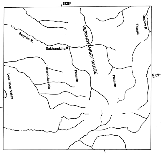
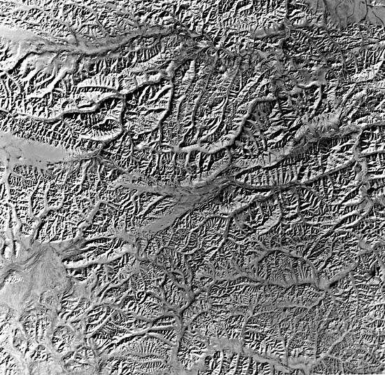
The scenes in the Plate and Figure T-29.1 and Figure T-29.2 depict the Verkhoyanskiy orogenic belt, a series of compound oroclines concentrated in the central part of the Verkhoyanskiy continental shelf. To the southeast, most of this shelf area consists of Jurassic and Cretaceous sedimentary rocks that remain largely undeformed.
| Figure T-29.1 | Figure T-29.2 |
|---|---|
 |
 |
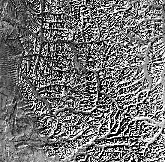
The scene in this Plate lies near the north end of the main Verkhoyanskiy Range, just east of the Lena River and a few hundred kilometers south of its great delta (Plate D-11). Along the left margin are mildly deformed Cretaceous and Quaternary rocks that comprise a flat terrain influenced by Lena drainage. Slivers of Triassic and Jurassic sedimentary rocks occupy the fault-controlled west end of the Verkhoyanskiy Range. The majority of units in this scene are north-striking beds of Permian age, with Triassic units appearing around the Omoloy River at the right margin. These clastic sediments (12 to 15 km in thickness) were derived from Siberian Mountains that had been folded, uplifted, and eroded in late phases of the same Hercynian orogeny that also affected the Uralides and parts of the Siberian platform.
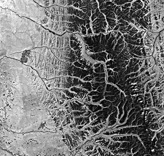
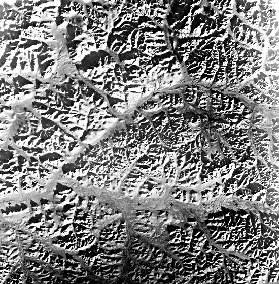
Figure T-29.1 depicts almost the same area, but was taken in late July when the snows had vanished. Together, these scenes provide a broader insight into the character of the mountains. They have a distinctive expression that is characteristic of other ranges in this part of the Kimmerian region (Figure T-29.2). The mountains tend to be rather low (below 2400 m), with about 1500 m of relief. On the west, linear ridges are carved from steeply dipping units. This strike-dominated fabric persists through the Permian units, which appear to contain repeated sections. Larger rivers have rather wide floodplains (glacially expanded?). Except for the Omoloy River, the major rivers are consequent, flowing eastward transverse to the structure. Although uplift has caused incisement of the main channels, enabling them to maintain their paths irrespective of underlying rock and structure, the drainage shows some secondary trellis patterns in conformity to the northerly structural trends. Well-developed terraces can be seen along the rivers. Note that several rivers have captured other drainage, and for others, stream piracy is imminent. The lack of respect of major drainage for structure suggests that it is superposed on or antecedent to the mountains.
| Figure T-29.3 | Figure T-29.4 |
|---|---|
 |
 |
About 800 km to the southeast, another major mountain chain, the Chersky Range (Figure T-29.3), rises to similar heights (3000 m). Triassic sedimentary rocks occupy the lower half of the scene. To the north is a belt of Jurassic rocks and a band of Lower Cretaceous intrusive granites and, near the top, older units of Silurian/Devonian age. Similar patterns of hill erosion, strongly influenced by bedding planes, are evident here. Several northeast-southwest-trending valleys seem to be fault-controlled, as evidenced by their linearity and the presence of triangular facets along the mountain face. Other ridges are broken by cross faults where rivers have cut across the topographic trend.
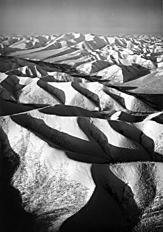
The northernmost part of the Kimmerian region is located along the Chukchi Peninsula. The smaller area, higher resolution Landsat RBV image in Figure T-29.4 captures a part of the snow-covered Chukchi Mountains (1400- to 1800-m altitudes), whose forms are emphasized by the low Sun angle. A window of Triassic rocks, invaded by Mesozoic intrusive, is dissected by the Pegtyrnel River. Most rocks in the scene are Upper Carboniferous volcanic deposits, emplaced during the early phases of the Alpine orogeny. The lack of bedding with contrasting resistance accounts for the somewhat "rounder" appearance of the hills.
The Trans-Baikal region of southernmost Siberia (Plate KL-14) extends across the eastern end of the Paleozoic Angara geosyncline to the southern end of the Kimmerian region. This is one of the widest belts of continuous intrusive rocks in the world. Multiple intrusions range from Proterozoic (mainly on west side), through Caledonian and Variscan (mostly central Trans-Baikal), to Mesozoic (east side). Elevations in this region are generally below 1200 m, but reach to 1700 m in the Yablonovyy Range. (NMS) References: Nalivkin (1960), Suslov (1961). Landsat 1221-02505-6, March 1, 1973.
Continue to Plate T-30| |Chapter 2 Table of Contents| Return to Home Page| Complete Table to Contents