 |
 |
|---|---|
| Plate T-4 | Map |
|
|
|---|---|
| Plate T-4 | Map |
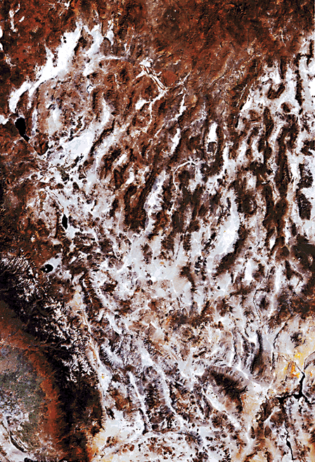
Elongate, generally north-trending, fault-bounded high mountain ranges and intervening dry, alluvium-filled, flat-floored valleys characterize the Great Basin or Basin and Range Province, which C. E. Dutton described as giving the appearance of "numerous caterpillars crawling toward Mexico" to a map of the region. The mosaic of Landsat images covering the state of Nevada dramatically illustrates this pattern, with the dark "caterpillar" ranges separated by light-colored valleys. The province is a vast area of extensional tectonics in the southwestern United States and northwestern Mexico.
The region is arid because it lies in the rain shadow of the Sierra Nevada. A few of the highest ranges (e.g., White Mountains, Toyabe Range, Spring Mountains, and Ruby Range) support conifer forests at higher altitudes. Because of the recent tectonic activity that produced the fault-bounded ranges and valleys and the general aridity of the region, almost all of the drainage is internal. Relatively short streams end in salt flats or playa lakes. Even the Humboldt River eventually dies in Carson Sink.
The area was not always so dry. Episodically during the Pleistocene, large lakes occupied many of the basins, which accounts for the exceedingly flat basin floors. Some old lake terraces are 100 m or more above the adjacent lake beds.
Recent tectonic activity also accounts for extremes in elevation, with Mt. Whitney (4418 m) in the Sierra Nevada and Death Valley (-86 m) less than 120 km apart. Two thousand meters of relief between adjacent ranges and valleys is not uncommon.
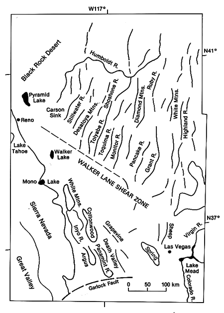
The precise processes and mechanics of tectonic extension are not entirely clear. Several factors seem to operate. A pervasive pattern of north- to north-northeast-trending normal faults bounds the ranges and valleys. Some of the ranges are horsts; others are tilted fault blocks. Several very long northwest-trending shear zones, such as Walker Lane and the Central Nevada Shear Zone, that parallel the San Andreas and display a similar sense of right-lateral movement, interrupt this pattern. The overall fracture pattern indicates a substantial component of right-lateral shear that appears to be the result of a right-lateral couple imposed on the region as the Pacific plate continues to slide northwestward relative to the North American plate along the San Andreas and related transform faults. The subduction zone, lying between the coast of Washington and Oregon and the Gorda and Juan de Fuca rises offshore to the west, acts as a free face that accommodates the resultant northwestward extension of the Basin and Range section of the North American plate. This northwestward expansion forces the subduction zone to the northwest, closer to the spreading rises. Similar extension of the continental plates over tectonic free faces appears to occur in western Turkey and eastern China and produces structure and topography analogous to that of the Basin and Range (Liviccari, 1979; Liviccari et al., 1982; Nelson, 1981; Zoback et al., 1981).
Internally within the Basin and Range, the extension results as a combination of attenuation of the lower crust and normal faulting of the more brittle upper crust. Attenuation of the lower crust (crustal thickness is approximately 10 km versus greater than 30 km elsewhere) occurs through a combination of low-angle brittle shear and viscous flow. Many of the upper crustal normal faults are listric, which accounts for the tilting of many of the fault-bounded ranges (Burchfiel and Davis, 1975; Smith and Eaton, 1978; Wernicke and Burchfiel, 1982).
| Figure T-4.1 | Figure T-4.2 |
|---|---|
 |
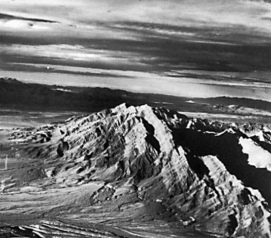 |
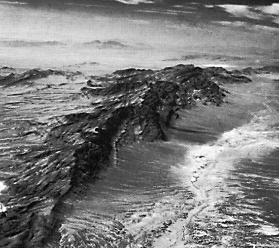
In some instances, asymmetry of the mountains indicates scarp and dip slopes. Steeper topography with short streams develops on scarp faces; gentler gradients and longer streams form on back (dip) slopes. On other ranges (horst types), dip slopes are not discernible, and the ranges are symmetrical. Most ranges are straight, at least at the base where the steep mountain sides abruptly intersect the basin floor. The steep slopes are heavily ravined with sharp V-shaped gorges. Triangular facets are common on interfluves between valleys. The ancillary photographs illustrate well the abrupt transition from flat- floored playas and gently sloping bajadas to the steep abrupt range fronts (Figures T-4.1 and Figure T-4.2).
Figure T-4.1 is an oblique view looking south toward the Arrow Canyon Range, Nevada. The tilted nature of the fault block is evident. Note the difference in stream length, depending on steepness of the dip of strata. Landforms on the east and west sides of the range are different. On the west, the steep range front is being covered with debris that is now being trenched, with the material removed into the center of the basin. Recent deformation has resulted in deep entrenchment and deformation of the fan on the north end of the range.
Figure T-4.2, looking north at Frenchman Mountains (east of Las Vegas, Nevada), shows another tilted fault block, in which differential erosion of hard and soft layers is quite evident. The alluvial fans are being actively entrenched. This entrenchment, as well as the linearity of parts of the front and what appears to be a recent fault cutting several fans, indicates active faulting. (JRE) Additional Reference: Christiansen and McKee (1978). Landsat Mosaic, prepared by the U.S. Geological Survey, Flagstaff, Arizona.
Continue to Plate T-5| Chapter 2 Table of Contents| Return to Home Page| Complete Table of Contents