 |
 |
|---|---|
| Plate T-41 | Map |
|
|
|---|---|
| Plate T-41 | Map |
Ophiolites represent the anomalous superposition of oceanic crust on top of continental crust. Few geologic features more clearly reveal the dynamic effects of seafloor spreading. Rather than a single rock type, an ophiolite is a stratified group of three separate rocks types, known as the "Steinman Trinity." The lowermost members consist of ultramafic peridotites, above which are layered to massive gabbros that in turn are source to and overlain by a volcanic member composed of sheeted dikes and pillow basalts. Ophiolite rocks are formed at the spreading ridges as reduced pressure allows partial melting in the Earth's mantle, generating the gabbro plutons which then feed the pillow basalts through fissures opened during spreading.
This scene covers much of the Semail ophiolite nappe comprising the Oman Mountains in northern Oman. Peridotites (P) are clearly visible as large dark massive rocks with a characteristic highly dissected drainage pattern. The gabbros (G) are not well represented on this image. Most are easily differentiated by their light color and coarser drainage pattern. Volcanic units (v) rimming the northern perimeter of this south-dipping nappe are distinctive in their dark color and characteristic low relief due to their lack of weathering resistance.
The northern edge of Oman and the rest of the Arabian platform broke away from the land areas to the north in the Early Triassic. For most of the Mesozoic, the Neo-Tethys seaway continued to open, creating a thick miogeosynclinal section of carbonates on the passive margin of the Arabian platform (lightest tones in the image). Lower Cretaceous age fossils in chert intercollated with the pillow basalts date the formation of the Semail ophiolites. The Neo-Tethys began to close in the Early Cretaceous. By Late Cretaceous time, accelerated by an anomalously high worldwide spreading rate, the old spreading center of the Neo-Tethys collided with the Arabian platform. The result of the collision was the emplacement of the Semail nappe on the Arabian craton (Glennie et al., 1973; Glennie, 1974; Welland and Glennie, 1975; Coleman, 1981).
| Figure T-41.1 | Figure T-41.2 |
|---|---|
 |
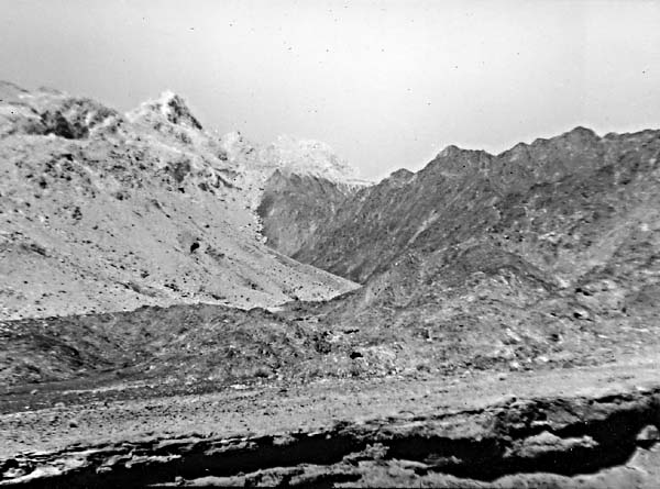 |
Sima (oceanic) crust is considerably more dense than sialic (continental) crust, with average specific gravities of 3.3 and 2.7, respectively. The isostatic imbalance created by superposition of massive sima crust on the Arabian platform is one explanation for the formation of the large folds observed in the autochthonous shelf carbonates of the Hajar (Hj) Super Group (Mesozoic). These have been domed up and eroded to expose the underlying pre-Permian (P) units at the Siat-Hatat in the northeastern corner of the scene. Nearby folding in response to diapirism extends westward until it takes an almost 90° left turn to the south for 20 km and then takes another 90° turn to the west, where it widens to form the Gebel Akdar window. At first glance, the apparent left lateral offset the Siat Hatat and Gebel Akdar might be interpreted as a transcurrent fault. However, close inspection of the imagery and in the field reveal no evidence of large-scale faulting within the autochthonous sections. These areas are interpreted instead as large-scale folding in response to crustal diapirism. Under the awesome loading created by the superimposed ophiolite, the crust began to buckle, probably along zones of weakness in the overlying ophiolite nappe. As erosion progressed, the ophiolite cover in the areas of the present folds became thinner, causing a positive feedback situation in which the more the folds rose, the more the ophiolite was unloaded. The final result is the high-standing Gebel Akdar, whose breached rim with inward-facing scarps stands over 3 km above sea level. Figure T-41.1 is an outcrop of a steeply dipping resistant unit within the ophiolite sequence. Figure T-41.2 depicts the contact of the ophiolites with the older shelf rocks (Dykstra and Russell, 1980).
The Oman salt basin, an offshoot of the Infracambrian Hormuz salts of Iran, extends up to the southern edge of the Oman Mountains. An arcuate fold of dark Tertiary limestone (T) formed as a salt pillow rose in response to the ophiolite loading. A more equidimensional salt dome (K) is clearly visible near the southeast corner of the scene, which also contains some excellent examples of braided river channels and coalescing alluvial fans. Young (post-obduction) limestones (L) stand out as light-colored patches overlying dark ophiolites.
| Figure T-41.3 |
|---|
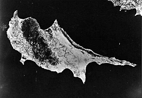 |
Figure T-41.3 is taken from a Large Format Camera photograph of another of the world's famous ophiolites, the Troodos Massif of Cyprus, best known for its mineral deposits of copper and chrome, first mined in the Bronze age. The geologic environment at spreading centers, where ophiolites are formed, is conducive to the formation of two general types of ore deposits: massive sulfide copper deposits and layered chrome deposits. Sulfide deposits in the Troodos ophiolites are produced as exhalative deposits where mineral-rich brines are exhaled on the seafloor and intercollated with the pillow basalts (Constantinov and Garett, 1973). The Semail nappe also has several massive sulfide and chromite deposits; however, none of the chromite and only one of the massive sulfide deposits are of economic grade. (GCW: J. D. Dykstra) Landsat 10127-06080, November 27,1972.
Continue to Plate T-42| Chapter 2 table of Contents| Return to Home Page| Complete Table of Contents