 |
|---|
| Plate V-21 |
|
|---|
| Plate V-21 |
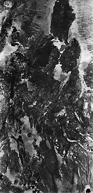
This superb Large-Format Camera (STS-41-G) scene might better be retitled "Birth of an Ocean," except for the missing water. The Afar Triangle lies at the most obvious triple junction (between the African and Arabian tectonic plates) visible anywhere on the Earth's surface. Here, three arms of an aulacogen-represented by the Gulf of Aden/ Red Sea/African Rift Valley-meet in an almost classic intersection with angles between arm pairs approaching 120°. The nature of this junction is reviewed, along with a broader treatment of the regional geology in Plate T-36. Oceanic crust has formed over the last 4 Ma in both arms now invaded by the sea (Barberi et al., 1972). At the Afar, oceanic basalts similar to those in the two marine arms have poured over older basalts and continental crust intermittently in the last 2 Ma. Thus, the surface seen in this plate displays many characteristics assumed to be typical of a newly formed volcanic crust proximate to a spreading center (see Iceland, Plate V-15).
The Afar occupies a relatively low region of northeast Ethiopia and extends to the district of Djibouti at the head of the Gulf of Aden, which terminates at the small Gulf of Tadjoura. Structurally, it is a lowlands located between the Ethiopian Plateau (west), the Somalian Plateau (south), the Aisha Horst (east), and the Danakil Horst (northeast). Parts of the Afar, such as the Danakil Depression, now lie below sea level (Gibson, 1969).
| Figure V-21.1 | Figure V-21.2 |
|---|---|
 |
 |
In places within the Afar, especially to the north, Precambrian basement, which is prevalent in the Ethiopian Plateau, is exposed. Marine sediments covered most of the region in the Mesozoic. This general region of East Africa/Arabia began to rise in a broad swell, the Afro-Arabian Dome (with Nubian, Somalian, and Arabian segments), in the Early Tertiary. This coincided with partial melting in the mantle, generating magmas that moved up along one or more thermal plumes. The first effusive lavas in the Eocene are represented by the basaltic Trap Series, which can be subdivided into an earlier, more alkaline phase and a later peralkaline phase (erupting during Miocene/Pliocene times; Mohr, 1983). These basalts show high Na/Si and Fe+3/Fe+2, high water content, and low TiO2.
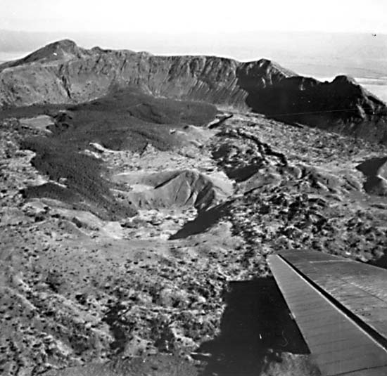
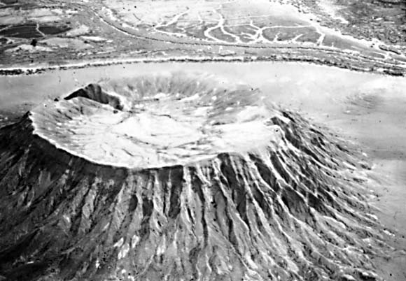
As the dome was subjected to extensional stresses during arching, great fissure systems developed that were precursors to the current fault zones associated with the arms. Graben tectonics prevailed, with normal faults often antithetic (Baker, 1972). Tholeiitic basalts first invaded the "oceanic" arms, then in Late Pleistocene/Recent times, spilled out within the Afar and in parts of the Ethiopian Rift to the south. Silicic crust maybe completely separated where the new Arabian plate (moving northeast) has split off, with the basalts now filling a fracture system deep into the lithosphere. Where the crust experienced strong attenuation, a tholeiitic lava type has emerged; elsewhere, coeval low-alkali basalts were extruded as the Aden Series. Later, tholeiites emplaced from fissures became the dominant type in the Afar; these layered flows comprise the Stratoid Series. The lavas flowed widely over the landscape, but here and there, small shield volcanoes, such as Dame Ale, calderas such as Fantale (Figure V-21.1), and guyot-like cones (Figure V-21.2), have built up.
| Figure V-21.3 |
|---|
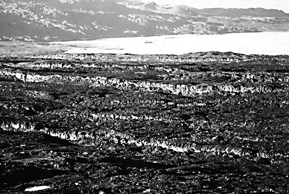 |
The present scene is remarkable for the numerous step faults (throws seldom exceeding 100 m) that cut through the Trap (largely buried), Aden, and Recent basalts (Mohr, 1975). These extensional faults, some producing rotated blocks, make distinctive cliffs (Figure V-21.3) within the topography. The principal trends of these faults are subparallel to the three aulacogenic arms. Over much of the Plate scene, the fault zone strikes northwest, but northeast of Lake Abbe (part of which is visible at bottom center), the trend is east- west; southwest of that lake is the northern end of the Wonji Fault Belt that connects with the main African Rift Zone. The lake itself lies quite near the "point" at the triple junction. To the west, faults and lineaments follow a north-south trend, roughly parallel to the contact with the highest Ethiopian Plateau. Transform faults have been postulated for the Afar, but significant horizontal offsets are not evident in the image; their surface expression may be sets of en echelon faults. Several grabens in the scene (e.g., Gawa) have curved boundaries, suggesting progressive rotation, with en echelon cross-faulting, perhaps controlled by movements of the Danakil horst. These and other depressions create internal drainage conditions, with entrapped waters becoming brackish to strongly alkaline; the white tones in the image coincide with gypsum and halite deposits. Contributor: Timothy Stacy, University of Maryland. Additional References: Barberi and Varet (1970) and Mohr (1975). Large Format Camera, October 31, 1972.
Continue to Plate V-22| Chapter 3 Table of Contents.| Return to Home Page| Complete Table of Contents