 |
 |
|---|---|
| Plate V-27 | Map |
|
|
|---|---|
| Plate V-27 | Map |
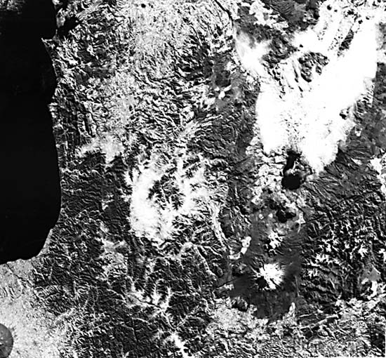
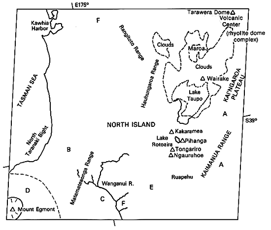
The North and South Islands of New Zealand lie on the active boundary between the Pacific and Indian/Australian plates (Brown et al., 1968). On South Island, much of the current plate motion occurs along the northeast- trending dextral Alpine transcurrent fault zone (see Plate T-58), which extends into North Island, passing southeast of this Landsat image. North Island itself is bordered along its east coast by the Kermadec Trench, a southward extension of the Tonga Trench. In Central North Island, a chain of andesitic volcanoes (part of the Circum-Pacific Andesite Line) erupts lavas from a melting zone (estimated depth around 150 km, based on earthquake hypocenters in the west-dipping subduction zone).
North Island was part of the New Zealand geosyncline that received sediments from the Carboniferous through Jurassic (Torlesse Supergroup) (Suggate, 1978). By Early Cretaceous, these deposits were strongly folded during the Rangitata Orogeny. In this Landsat image, Jurassic/ Triassic rocks, mainly graywackes, form the distinctive mountain terrains of the Kaimanawa and Hauhungaroa Ranges. Much of west-central North Island is covered by Tertiary (mainly Pliocene) shallow marine sediments that eroded into the fine drainage network in the mainly forested Matemateaonga Range. These sediments have been warped and locally folded by the Kaikoura Orogeny that began in the Miocene and continues even now.
| Figure V-27.1 | Figure V-27.2 |
|---|---|
 |
 |
The chain of volcanoes trending north-northeast in the eastern center of the image is confined to a narrow structural trough variously interpreted as a tectonic graben related to major rifting or as a shallow linear (elongate) 50 by 250 km depression caused by collapse following magma withdrawal (Hazen, 1965). Volcanic activity has marked this line from the Pliocene to the present. This area, referred to as the Taupo (or Central) Volcanic Zone, takes its name from Lake Taupo (mostly cloud-covered), an irregular caldera-like depression developed both by collapse and by explosion at multiple volcanic centers. The Wairakei geyser field is located just north of this lake. The greatest eruptions in the Taupo Zone have been from the silicic volcanic centers of Taupe, Okataina, and Maroa, generating more than 15 000 km3 of welded ignimbrites and other ejecta. These ignimbrites form gently sloping plateaus on either side of the Zone, covering more than 30 000 km2. The smooth form of the Kai'ngaroa Plateau west of Lake Taupo is particularly evident in the Landsat image; the "fields" on the plateau at A are clear-cut and reforested stands of conifer trees, which flourish in pumiceous soils. The western plateau is more stream-furrowed. The Taupo Center has been described as an inverse volcano (Walker, 1980). Its eruptions are exceptionally powerful, causing wide dispersal of its disgorged products. The thick deposits of this material form a great bowl-shaped depression (filled with mist in this scene) some 30 km in diameter. The rhyolite dome-cluster of Tarawera Mountain (visible in the upper right corner of the image) is one of several in the Okataina Center; 150 people were killed by a violent fissure eruption of basaltic material in June 1886 that cored out the explosion craters seen in Figure V-27.1. A zone of prominent extensional faults, with the tilted horst of Paeroa Mountain among them, connects both centers. A cluster of rhyolitic domes in the Maroa Center is visible in a gap within the mist clouds.
| Figure V-27.3 |
|---|
 |
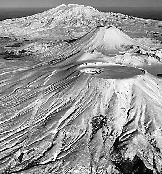
South of Lake Taupo are three prominent andesitic volcanoes, shown from the air in Figure V-27.2: Tongariro (1986 m), with its conspicuous North Crater in the foreground, Ngauruhoe (2291 m), the conical stratocone in the middle ground, and Ruapehu (2797 m), the broad stratocone in the background. Only Tongariro has not erupted in this century; Ngauruhoe is the most active, commonly producing tephra showers, pyroclastic flows, and lava flows (Topping, 1973); Ruapehu has occasionally produced steam explosions and lahars from its glacier-girdled crater lake. A "ring plain" of lahar and rock avalanche deposits lies to the southeast of Ruapehu. The volcanoes in the Tongariro Volcanic Center are older than the ignimbrite plateaus to the north. Note the prominent structural lineaments trending east-northeast along the eastern flank of this center.
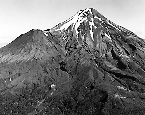
In the lower left corner of the Plate image is the lofty snowcapped Mount Egmont (2630 m) (Figure V-27.3), the youngest (and largest) of three volcanoes (others not visible) formed along a north- northwest line on the Taranaki Plains east of Cape Egmont. This andesitic volcano (last active 250 to 400 years ago) was built on Pliocene marine sediments in the Pleistocene. The dark circular area around Mt. Egmont is a temperate rain forest preserve surrounded by an enclosing fence that excludes grazing animals from the higher slopes. Text modified from comments by R. Bailey, USGS, and G. P. L. Walker, University of Hawaii. Landsat 30844-21121-6, June 26, 1980.
Chapter 3 References| Chapter 3 Table of Contents.| Return to Home Page| Complete Table of Contents