 |
 |
|---|---|
| Plate V-7 | Map |
|
|
|---|---|
| Plate V-7 | Map |
The southern fringe of the Columbia Plateau and beyond contains some of the youngest basaltic flows in the Pacific Northwest. Much has transpired to reshape the landscape in the past 20 Ma. Along a line running from northern California/ southern Oregon through southern Idaho into Yellowstone/ Wyoming/Montana country, volcanism associated with tectonic deformation has created distinctive landscape elements. Christiansen and McKee (1978) ascribe this activity to the onset of extensional tectonics that ultimately has depended on interactions of the North American, Pacific, and Farallon plates and the northward migration of the Mendocino triple junction. This fostered a chain of heating events accompanied by widespread crustal foundering and block-faulting during regional uplift. This resulted in thinning, lowered rigidity, brittle deformation, basal crustal melting, and widespread outpourings of bimodal lavas (rhyolites and basalts) as extension afforded opportunity for relief of thermal stresses induced at depth. Both the High Lava Plains (Figure V-7.1) and the Snake River Plains (this Plate) to their east are astride the transition between the older Columbia Plateau volcanism and the younger Basin and Range faulting (with its sporadic volcanism) that runs south into Mexico (Christiansen and Lipman, 1972).
The oldest part of this southern volcanic province is the Owyhee Uplands, a series of isolated, dissected mountains and incised plateaus that contain rhyolites and latites. These grade into younger lavas, mainly basalts in the Boise/ Malheur section of eastern Oregon/western Idaho, well exposed in deep canyons. The intermittent nature of the volcanic activity is illustrated by fine (often powdery) lake and river sediments interbedded with the basalts.
| Figure V-7.1 | Figure V-7.2 |
|---|---|
 |
 |
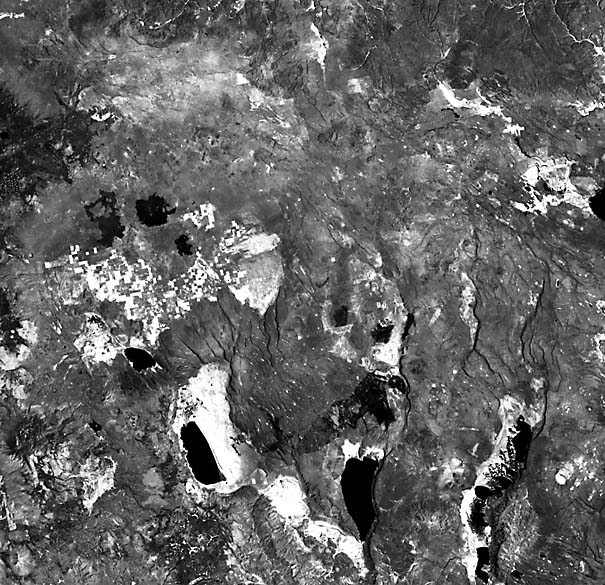
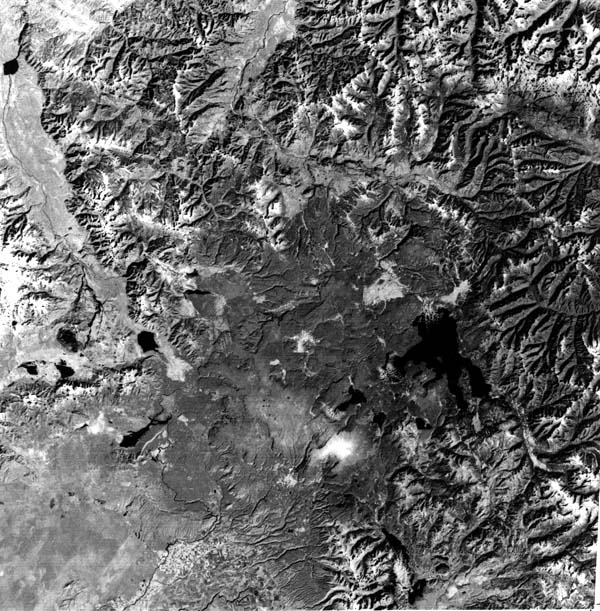
Most of southeastern Oregon contains lavas extruded in the last 10 Ma along northwest fissures cutting through the Harney-High Desert section of the High Plains (Robyn, 1979). The resulting countryside, as seen by Landsat (this Plate), is one of low-relief desert-like surfaces, fresh lava features, including cinder cones and lava- capped buttes (see Plate V-6), and ridges that show prominent fault scarps (step-fault terrain reminiscent of parts of the very young terrain in the Afar Triangle (Plate V-21)). The influence of the northern Nevada/California limits of Basin and Range topography carries over into uplift blocks such as Abert Rim, Hart Mountain, and Steen Mountain. Despite the youthful appearance of the terrain, as in the Great Sandy Desert shown here, the volcanism traces its history back to about 17 Ma ago, continuing spasmodically until about 1 Ma ago, with subordinate basaltic flows in the Newberry Volcano area and pumice deposits from the Cascades since then.
There is a progressive eastward shift in age toward younger volcanic outflows proceeding through the Snake River Plains. The older segment makes up a structural trough trending northward from the Malheur/Boise Basin east to Mountain Home, Idaho. Middle to Upper Miocene rhyolites/basalts have since been covered by lavas through the Late Tertiary. The Plains subprovince undergoes a deflection to the northeast through east-central Idaho, where a downwarp and faulting produced a trough that holds lavas as old as 14 Ma. Mostly olivine tholeiite lavas, several thousand meters thick, have accumulated under the Plains.
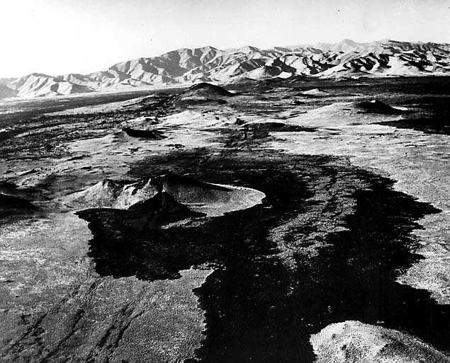
R. Greeley (1982a, 1982b) proposes the Snake River Plain as a new category of volcanic activity, which he terms basaltic plains volcanism, intermediate between plateau flood basalt and Hawaiian shield volcanism. This terrain is characterized by low shield volcanoes, fissure flows from point sources rather than linear sources, and tube-fed flows (Figure V-7.2).
| Figure V-7.3 | Figure V-7.4 |
|---|---|
 |
 |
Fissures, however, controlled extrusion at the Craters of the Moon Lava Field and the Wapi flow (Prinz, 1970). Lines of cones and spreading lavas (Figure V-7.3) concentrate along the Great Rift and Kings Bowl fracture zones. Details of the constructional surfaces in these quite young lava fields stand out in the aerial photo showing the north edge of the Craters of the Moon National Monument (Figure V-7.4). Flow ages in the larger field are qualitatively separable in the image by variations in darkness or gray level of the surfaces because these weather over time. Vegetation is sparse on these basalts, keeping soils at minimal thickness, as streams readily disappear into the porous fractured lava flows from which high-volume springs emerge. Subordinate rhyolitic volcanism in the Plains progressed eastward with time, culminating in the Island Park caldera complex at the east head of the Snake River Plains and the still-continuing activity at Yellowstone National Park that may have been driven by a mantle plume source at depth (see Figure 3-3 in the chapter introduction). Caption modified from comments by R. Greeley, Arizona State University. Additional Reference: Leeman et al. (1976). Landsat 1358-17471, July 16, 1973.
Continue to Plate V-8| Chapter 3 Table of Contents.| Return to Home Page| Complete Table of Contents