 |
 |
|---|---|
| Plate V-9 | Map |
|
|
|---|---|
| Plate V-9 | Map |
In several respects, the 3200-km long arc running from the Alaskan Peninsula west almost into Asia at the Kamchatka Peninsula is the classic example of a trench- bordered eugeosynclinal cluster of volcanic islands that fall on the continental side of a major subduction zone. The arcuate Aleutian Ridge, convex southward, rises subaerially to average heights around 650 m along a truncated surface, but on the ridge, the Aleutian Range reaches elevations in excess of 1200 m and some volcanoes exceed 2500 m (Lathram, 1974). The Aleutian Trench, near the top of the Benioff Zone, is deeper than 7000 m in places; in between is the seaward sloping Aleutian Terrace that bottoms around 4000 m at the trench hinge. On the north side of the arc is the Aleutian Basin, a back-arc basin that attains depths of 3500 m in the western Bering Sea. However, this arc/trench system differs from others, such as the Japanese and Indonesian orogenic belts, in lacking a well- defined outer nonvolcanic forearc basin and a paired metamorphic belt.
The present arc complex-the result of the plunge of the Pacific plate under the west margin of the (overthrusting) North American plate-began in the Cretaceous as ophiolites, oceanic sediments, and basalts collected in a constructional pile to thicknesses of 10000 m through the Early Miocene. Volcanogenic sediments and flows since then remain the dominant geosynclinal deposits. As the ridge built up above the sea, sedimentation patterns were shifted with the reduction of the Aleutian Basin. Basaltic volcanism prevailed in the earlier phases, with a period of quiescence in the Miocene except for emplacement of plutons, and resumption of active volcanism (calc-alkaline with andesites and some rhyolites) from Late Miocene to the Holocene. Folding followed by faulting, metamorphism to the greenschist stage, marked intermittent deformation that climaxed in an extended orogeny from Early Miocene to Late Pliocene. The Aleutian Ridge, which has undergone considerable vertical uplift, has remained stable since the Pliocene.
| Figure V-9.1 | Figure V-9.2 |
|---|---|
 |
 |
Tertiary volcanic centers and Quaternary andesitic volcanism are concentrated along four arc segments that are subdivided by transform fault zones running north-south in the Pacific Plate (Kay et al., 1982). Most Quaternary volcanoes are stratocones; some now have calderas that developed when ashflows carried away the underlying supporting magmas. In general, the large volcanoes have associated tholeiitic lavas, but not typical island arc tholeiites; smaller volcanoes tend to be andesitic (Kay et al., 1982).
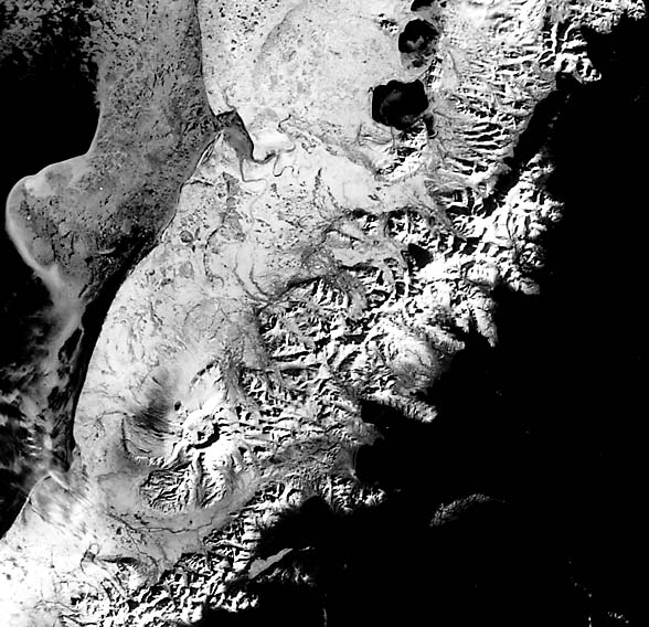
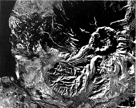
Both this Plate and the superb aerial radar mosaic (Figure V-9.1) highlight the Aniakchak caldera on the Alaskan Peninsula. This still-active volcano, once more than 2000 m high and nearly 40 km wide at its base, sits on a plains just north of the AleutianRange, a folded sequence of Jurassic, Cretaceous, and Tertiary sediments mixed with volcanic tuffs, agglomerates, and flow units. The eruptive collapse (in Early Pleistocene?) that formed the present 9.5 km diameter, 1000 m relief crater, has expelled ash over 2500 km2 to thicknesses of 100 m or greater in the preexistent gullies and valleys on and beyond the original volcano. Ashflows actually move up onto slopes of the Aleutian Range. The glaciofluvial deposits that mantle the lowlands on the Bering Sea side are covered by this ash near the crater, as evidenced by the sharp decrease in numbers of lakes in the vicinity of Aniakchak. Aniakchak Crater (Figure V-9.2), whose nature was not fully discovered until it was entered by surveyors in 1922, is breached by the Aniakchak River that drains the small Surprise Lake at a gap called the Gates. Other volcanoes including the older Mt. Kialagak and the active Mt. Chiginagak fall along a line that serves as the central axis of this section of the Peninsula.
| Figure V-9.3 |
|---|
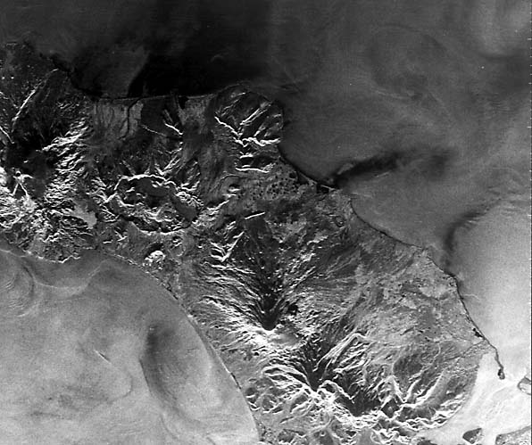 |
One of the most graceful cones in the Aleutian chain is Shishaldin Volcano on Unimak Island. This 2858 m high volcano has erupted more than 25 times in the last 200 years. A hint of this conical symmetry is evident in the Seasat L- band radar image (Figure V-9.3), but the layover effect distorts the form. The nearby older Isanotski volcano is more extensively dissected and is topped by an eroded (partially glacial) peak. On the south end of Unimak, Westdahl Peak shows its small circular vent to advantage in the radar view. A huge crater (18 by 11 km and about 1070 m deep), known as Fisher caldera, is possibly a remnant of a stratocone that released great volumes (20 m thick in places) of andesitic ash, pumice, and bombs that spread out in several directions through valleys and even up over the Tugamak Range (top center). Additional References: Miller and Smith (1977) and Smith (1925). Landsat 30341-20591-5, February 9, 1972.
Continue to Plate V-10| Chapter 3 Table of Contents.| Return to Home Page| Complete Table of Contents