 |
 |
|---|---|
| Plate F-14 | Map |
|
|
|---|---|
| Plate F-14 | Map |
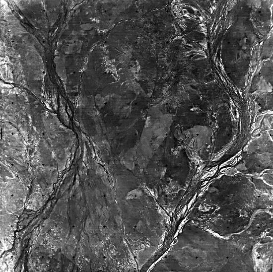
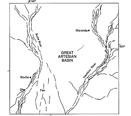
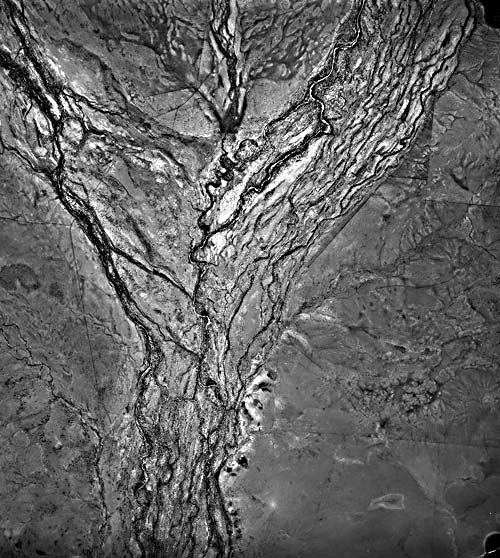
The portions of the Burke and Hamilton Rivers shown on this Landsat image are typical of the low-gradient multichannel alluvial systems that are common in southwestern Queensland, Australia (Rust, 1981). This region of 1.3 million km2 is known as the "Channel Country" (Figure F-14.1). Channel Country stream systems are characterized by extremely low gradients and clay substrates. Tributaries are organized locally into high-density networks on the relatively impermeable soils (Figure F-14.2). The image shows an area where rivers emerge from highlands surrounding the Lake Eyre drainage basin. The highlands are semiarid to seasonal humid tropical, reaching 50 cm annual rainfall in the Great Dividing Range east of this scene. Rainfall in the headwaters occurs predominantly during the summer monsoon season. The streams are ephemeral, flowing only in discrete flood seasons that are separated by long droughts. Between flows, stagnant water is retained in the deeper channel reaches. Such waterholes are critical elements in the ecosystem and in the grazing economy.
The Burke, Hamilton, and other Channel Country rivers flow toward Lake Eyre, a playa covering 9200 km2 in the driest part of Australia. Lake Eyre can be as much as 17 m below sea level and receives a mean annual rainfall of less than 10 cm. The Landsat scene is approximately 600 km northeast and upstream of Lake Eyre, in a region with 25 cm mean annual precipitation. The Channel Country rivers lose water through evaporation and infiltration as they flow toward Lake Eyre. Lake Eyre justifies its name only during exceptionally wet periods. In this century, the lake filled briefly in 1949-1950 and more extensively in 1973-1978. The relatively high river flows that sustained the lake in the middle 1970s probably were the result of global climatic aberrations, which affected the monsoonal patterns over the highlands.
| Figure F-14.1 | Figure F-14.2 |
|---|---|
 |
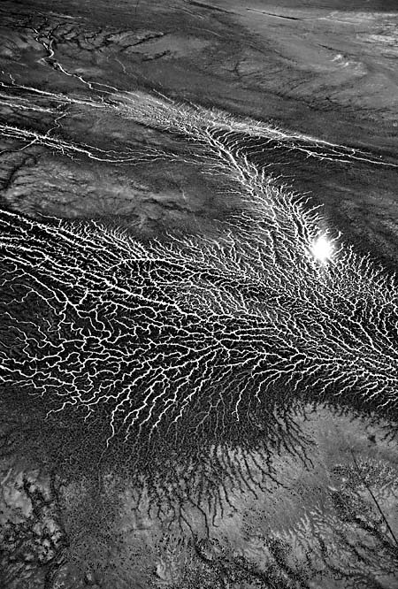 |
The multichannel systems of the Burke and Hamilton Rivers include sinuous larger elements and a reticulate network of relatively straight short segments. The latter are related to dessication cracks that develop in the abundant swelling clay that is transported by the rivers. Channel migration in these anastomosing systems occurs mainly by avulsion, rather than by gradual migration as in meandering systems. Figure F-14.3 is a low-altitude aerial photograph of the reticulate pattern in the Hamilton River drainage.
The Burke River drains a large portion of the southern Isa Highlands, which are underlain by Precambrian crystalline rocks. The highlands include considerable areas 300 to 600 m in elevation. The Hamilton River drains much less of the highlands, which may account for the fact that it does not show a large fan as it emerges from the higher country to the north. In contrast, the Burke River has an immense low-gradient fan, which displays braided paleochannels.
| Figure F-14.3 | Figure F-14.4 |
|---|---|
 |
 |
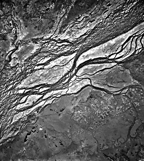
Augering by Australian geologists has revealed that the surficial clay emplaced by western Queensland streams constitutes a thin sheet less than 5 m thick. The clay is regionally underlain by a sand sheet that was deposited by relict braided streams (Veveers and Rundle, 1979). Thus, a major shift occurred in the fluvial regimen for Channel Country rivers. An older braided system emplaced sandy braid bars, and this system was altered to one characterized by anastomosing sinuous channels that covered the relict braids with overbank muds. Figure F-14.4 is a low-altitude aerial photograph showing the anastomosing channels and relict braid bars of the Burke River system.
Climatic change appears to be the most likely explanation for the pattern metamorphosis of the Channel Country rivers. The mud veneer could be associated with a shift from relatively wetter conditions in the Early Holocene, 7000 to 5000 years B. P., to relatively drier conditions at present. The system is still in adjustment because the relict braid bars continue to influence the modern fluvial system. Smaller anastomosing channels flow as underfit streams within the larger relict braided channels Landsat 30170-23570-B, August 22, 1978.
Continue to Plate F-15| Chapter 4 Table of Contents. Return to Home Page| Complete Table of Contents|