 |
 |
|---|---|
| Plate F-19 | Map |
|
|
|---|---|
| Plate F-19 | Map |
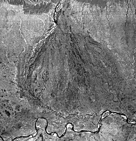
The Ganges River plain drains the Himalaya Mountains immediately to the north of this Landsat scene. Belka Hill is a part of the Siwalik Hills, which mark the southern margin of the Himalaya Range. These hills are generally 1000 to 1300 m above sea level and consist of dissected Miocene and Pliocene continental fluvial sediments deposited as the Himalayas formed by the continental collision of the Indian subcontinent into Asia.
The northern quarter of this scene is in Nepal and shows the emergence of the Kosi River from the mountainous extreme eastern end of that nation. The drainage basin includes the highest portion of the Himalayas, with many peaks rising 6000 to 8000 m above sea level. Mount Everest, the highest point on Earth at 8848 m, is within the source basin. Annual precipitation in the source area ranges from 130 to 165 cm/yr. However, 80 to 95 percent of this precipitation occurs during the summer monsoon (June to September).
Monsoons are tropical weather phenomena involving reversals of the prevailing wind directions between winter and summer. The reversals arise from a latitudinal migration of wind belts with the season. The winter monsoon of the eastern Ganges plain is a dry subsiding air current directed from the northeast. The Himalayas shield India from the cold continental air of inland Asia north of the Tibetan plateau. In summer, a deep trough develops over northern India, and a southwesterly flow of warm wet air from the Indian Ocean produces the summer monsoon. The warm wet air generates maximum precipitation under the orographic influence of the Himalayas. The resulting summer floods can cause the Kosi River to attain a width of over 30 km on the nearly flat Ganges plain. During the flood of 1968, the Kosi River achieved a maximum discharge of 25840 m3/s (about 900000 cfs). This flow from a catchment area of 59540 km2 is comparable to a moderate flood on the Mississippi River, which drains 3270000 km2.
| Figure F-19.1 | Figure F-19.2 |
|---|---|
 |
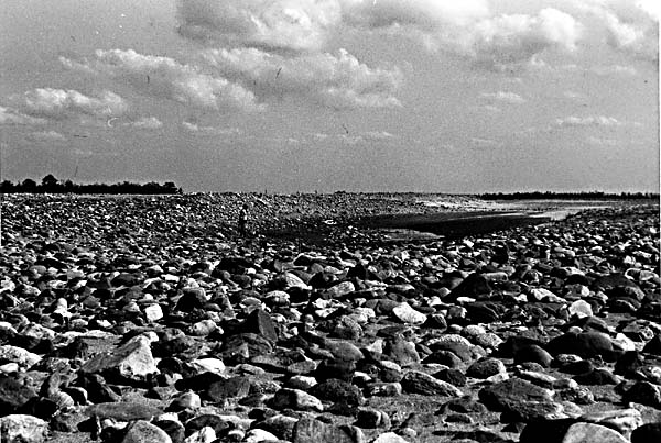 |
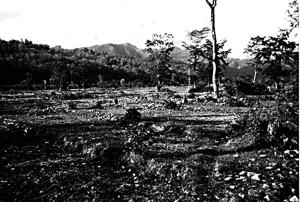
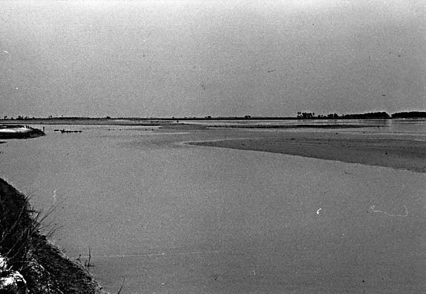
The Kosi River emerges from the Siwalik Hills near the town of Chatra, where old fan surfaces and adjacent hills have a savanna forest cover (Figure F-19.1). The channel pattern near Chatra is braided, and the sediment load is dominated by boulders transported during wet-season flooding (Figure F-19.2). The Landsat scene shows dry- season conditions, with the low flows visible as black and the braided wet-season channels as bright patterns immediately to the west. A dam is located downstream of Chatra, and a diversion canal is clearly visible extending eastward from the river barrier. Near Saharsa (Figure F-19.3), the sediment load is predominantly sand, and the pattern is anastomosed with fine-grained sediment banks. Farther downstream, the pattern becomes meandering as sediment size is reduced and gradient decreases.
The Kosi Fan, outlined by the dashed lines on the index map, covers an area of approximately 15000 km2 (Gole and Chitale, 1966). The fan has an extremely low gradient. The slope at its apex, near Chatra, is 1 m/km, and this decreases distally to less than 0.2 m/km near the Ganges River. The paleochannels at the fan apex have diffuse patterns that indicate probable braiding when they flowed. Near the fan toe, the abandoned paleochannels are meandering. High-water-table conditions and local (non- Himalayan) rainfall result in some continuous flow in these channels. Some sandy point bars are present, but most of the sediment is suspended clay.
| Figure F-19.3 |
|---|
 |
Between 1736 and 1964, the Kosi River shifted 110 km from east to west, reworking all the land in between (Gole and Chitale, 1966). Unlike arid-region alluvial fans, which show somewhat random shifts of erosion and deposition, the Kosi Fan developed by a progressively shifting channel. The shifting occurred as deposition raised the active portions of the fan and the river moved to lower terrain on the inactive portions. Because this process is now occurring on the extreme western end of the fan, there is a strong possibility that migration will now begin toward the east. A major shift to the east by avulsion would also be possible, were it not for massive artificial levees constructed to stabilize the river in its present position.
Braiding in the active western channel of the Kosi extends much farther down the fan than the braiding in the paleochannels to the east. It is probable that extensive deforestation of the headwaters in recent decades (Figure F-19.1) resulted in increased coarse sediment loads to the river. Water diversions may have also contributed to the increased braiding of the modern Kosi River. Landsat 2751-03455-7, February 11, 1977.
Continue to Plate F-20| Chapter 4 Table of Contents.| Return to Home Page| Complete Table of Contents|