 |
 |
|---|---|
| Plate F-2 | Map |
|
|
|---|---|
| Plate F-2 | Map |
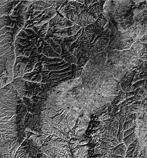
This scene shows the Fen River (Fen He) valley near the major steel-making center of Taiyuan (pop. 2 725 000), Shanxi Province, China. The major river valleys here expose Triassic sedimentary rocks. The Taiyuan Basin is filled with Cenozoic lakebeds and alluvium of the Fen River. To the west is the Lüliang Shan, a mountain range that uplifts Paleozoic units and Late Precambrian crystalline rocks. The Huo Mountains to the southeast are a tilted block of Paleozoic sediments that reach an elevation of 2545 m.
The climate of this region is hot and dry. The lowlands receive about 500 mm of annual rainfall, but the Lüliang Shan receives over 750 mm. The rains come principally in the summer. Population densities along the river bottoms are about 50 people per km2. Farming is the principal activity, but industrial areas occur at the northern end of the image.
Except for the Lüliang Shan, the entire region is blanketed with loess. Indeed, the Loess Plateau of central China is probably the greatest single pile of terrestrial eolian silts. The loess mantles about 320 000 km2 in the Chinese provinces of Shanxi, Shaanxi, Gansu, and Ningxia. It thickens markedly to the east, where one section near Lanzhou City is 335 m thick.
| Figure F-2.1 | Figure F-2.2 |
|---|---|
 |
 |
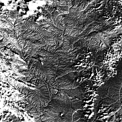
A Landsat scene immediately to the North (2287-02344-7) is shown in FigureF-2.1. The prominent river in the center of the image is the Huang He (Yellow River). Because of its huge sediment load, the river appears as lighter gray tones, even on this Landsat band 7 image. In the Lüliang Shan, the transition from lowland grassland to upland broad-leaved forest follows the 1500-m contour.
The SIR-A radar scene (Figure F-2.2) is centered on the Huang He approximately 60 km north of the Landsat scene. In this picture, the Lüliang Shan gives a bright radar response because the forest canopy is rough relative to the radar wavelength. The very bright spot near the lower right is the city of Lanxian. The city of Xingxian is the bright spot at the right center of the image.
| Figure F-2.3 |
|---|
 |
The radar provides an excellent depiction of two major types of loess plateau morphology (Derbyshire, 1983). The far western (left) end of the image shows areas of flat undissected plateau, which are called "yuan." The highly dissected loess at the center of the image consists of elongate ridges between gullies. The ridge topography, as seen in an oblique aerial photo (FigureF-2.3), is called "liang." Another type of loess topography, not shown here, consists of hemispherical hills known as "mao."
Both the yuan and liang are being dissected by headwardly extending gullies. The gullies are box-shaped and have very low gradients. They deepen until reaching bedrock and extend themselves through large-scale piping. Approximately 236 km2 of the Loess Plateau is subject to this type of accelerated erosion. Drainage basins may yield over 30 000 metric tons of sediment per km2. During storms, the loess will flow in slurries that are 50 to 60 percent sediment by weight. Such tremendous erosion contributes phenomenal amounts of sediment to the principal rivers. Landsat 1524-02394-7, December 29, 1973.
Continue to Plate F-3| Chapter 4 Table of Contents.| Return to Home Page| Complete Table of Contents|