 |
 |
|---|---|
| Plate F-23 | Map |
|
|
|---|---|
| Plate F-23 | Map |
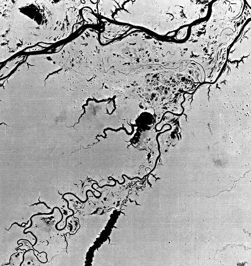
This Landsat scene shows the natural color of an area centered approximately 300 km southwest of Manaus. Figure F-23.1 is a hypothetical cross section through the Holocene floodplain (Baker, 1978a). The important features are levees (restingas), alluvial islands (ilhas), second-order channels (smaller channels on the varzea), landslides (terras caidas), and tributaries draining sediment-deficient uplands (terras firmes) to lakes at the varzea margin (ria fluviales). Figure F-23.2 is an older Landsat scene of the same area in band 7 (Landsat 1008-13481-7, July 31, 1972). Note the effect of sediment load (bright response) on the color image.
The two major rivers, the Solimões and Purus, have developed Holocene floodplains, which in Brazil are named "varzeas" (Baker, 1978a). The floodplains are inset into uplands underlain by deeply weathered Neogene sediments. These are termed "terras firmes."
The dominance of the Solimões in Holocene sedimentation history is indicated by the immensity of its varzea. The Purus has been forced to hug the eastern margin of the Solimões at the upper right of the picture. The index map records the location of the varzea and several rias fluviales in the northern part of the scene.
| Figure F-23.1 |
|---|
 |
The "rias fluviales" are clear-water lakes formed where streams draining the rainforest of the terras firmes are dammed at the varzea margins. Lake Aiapuá, at the center of the image, is a typical example. Such lakes may have small deltas at their heads, but generally they receive very little sediment.
The anastomosing pattern of the Solimões River is very prominent. The river has a low sinuosity and a high width-to- depth ratio for its channel. Sediment load data show that the river transports mainly suspended load. The river apparently maintains several active thalwegs because of its very high discharge. Islands between the channels are maintained by the rapid plant colonization of overbank sediments. Their long-term stability is indicated by archaeological material, which on one island was dated by radiocarbon at 2050 ± 120 years B.P. (Sternberg, 1959). One conclusion about the dynamics and morphology of Amazon Basin rivers is that they cannot be understood by merely scaling up our concepts of smaller rivers.
| Figure F-23.2 |
|---|
 |
Recent studies of suspended sediment concentrations and discharges of Amazon Basin rivers have been conducted by Robert H. Meade, Carl F. Nordin, and others of the U.S. Geological Survey. The pattern of sediment storage and remobilization downstream of Manaus is dominated by the Madeira River, which transports the largest sediment load of any Amazon tributary. Since the Madeira reaches its peak discharge 2 months earlier than the Amazon mainstream, the main river stores sediment on its rising stages and remobilizes it during its falling stages. The Madeira drains the Andean Cordilleras of southern Peru and western Bolivia. More than 75 percent of the suspended sediment provided to the Amazon system comes from the tributaries that directly drain the Andes. Sediment is probably derived from the erosion of older Quaternary terrace alluvium in the Andean foothills. Landsat 50115-13475, June 14, 1984.
Continue to Plate F-24| Chapter 4 Table of Contents.| Return to Home Page| Complete Table of Contents|