 |
 |
|---|---|
| Plate F-26 | Map |
|
|
|---|---|
| Plate F-26 | Map |
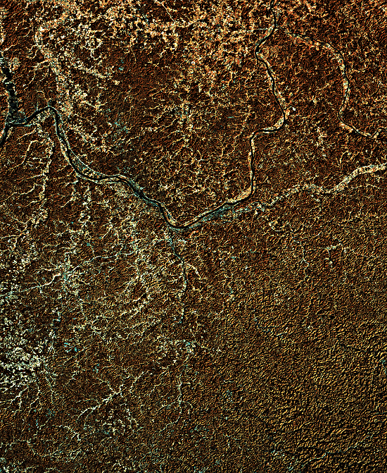
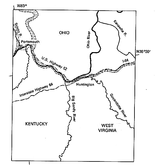
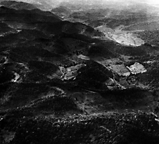
This enhanced Landsat mosaic shows the region where the states of Ohio, Kentucky, and West Virginia join near Huntington, West Virginia. The distinctive high-density dissection of the uplands results from intricate dendritic drainage on the generally flat-lying sediments of the western Appalachian Plateau. Almost all the rocks are Paleozoic sandstones, siltstones, and shales, which are easily eroded in the humid-temperate climate. Figure F-26.1 is an aerial photograph showing such topography in great detail, and Figure F-26.2 is an oblique low-altitude photograph.
The Appalachian Plateau dissection noted above can be considered to display a mature phase of erosion. In the idealized concept of fluvial dissection of a landscape, proposed by W. M. Davis (1899), youthful topography is characterized by broad undissected interstream tracts and divides. Steep gullies may be actively eroding as in the Loess Plateau of China. In mature dissection (Figures F-26.1 and F-26.2), the drainage divides are reduced to sharp ridges, resulting in a minimum of interstream uplands. This produces the maximum possible relief. In old age, the divides are reduced, although some high-relief areas may be left as erosional residuals. Removed of its genetic implications, the scheme can provide a useful description of drainage evolution.
The Ohio River is the major drainage element in this study area, but it has only occupied its present position since the Late Pleistocene. A prominent paleovalley (stippled pattern on the location map and "bands" without ribbon of river in photo) represents the ancestral trunk river in this region. This paleovalley is part of the Teays River system, the preglacial drainage from which the present Ohio River evolved. The preglacial Teays drained northwestward from the Blue Ridge of Virginia across West Virginia and Ohio. Its course can be traced by numerous wells in Ohio, Indiana, and Illinois, where its westward-trending valley is buried by glacial drift (Thornbury, 1969).
| Figure F-26.1 | Figure F-26.2 |
|---|---|
 |
 |
The advance of Pleistocene ice over the Teays River course caused the drainage to shift from the Teays route to a route roughly paralleling the glacial boundary. The modern Ohio River does the latter. However, the timing of the shift is uncertain because of difficulties in dating the complex sequence of drift in the region. Paleomagnetic studies of fills in the Ohio portion of the Teays Valley indicate an age greater than 0.7 million years.
The portion of the Teays Valley extending east-west from Huntington is filled with Late Tertiary alluvium and Early Pleistocene lacustrine clay. The data indicate that the Teays was an active system until Early Pleistocene glacial ice dammed its upper course. Then, either the divide near Portsmouth was overtopped by the lake or piracy from the evolving Ohio system captured the Teays headwaters. Paleomagnetic data indicate that the lake existed from approximately 1.7 to 1.0 million years ago.
The final result was the shift of Appalachian Plateau drainage to the Ohio River course. The modern Ohio River Valley carries the later Pleistocene fluvial record of this region. The uppermost sediments of the Teays paleovalley consist of loess, emplaced by eolian activity during the cold/dry phases of the Pleistocene. Landsat 2386-15280 and-15282, February 12, 1976.
Continue to Plate F-27| Chapter 4 Table of Contents.| Return to Home Page| Complete Table of Contents|