 |
 |
|---|---|
| Plate F-5 | Map |
|
|
|---|---|
| Plate F-5 | Map |
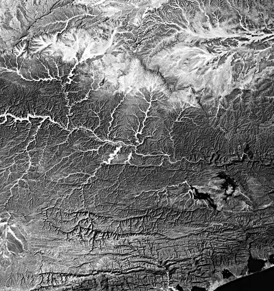
The nation of South Yemen (or Aden) is located at the southern end of the Arabian Peninsula. This Landsat scene shows a portion of the Hadhramut Plateau of central Yemen. The plateau is underlain by Early Tertiary sediments that dip northward toward the Rub´al Khalí Basin. The sediments represent Paleocene transgression that emplaced a sequence of limestones, the Jeza Formation, overlain by an evaporite sequence, the Rus Formation. These two units have extensive exposure and very different patterns of dissection and erosion.
The Hadhramut Plateau was deformed in the Tertiary into several broad anticlines and synclines. The major drainage, Wadi Masila (or A1-Masilah), flows along the general axis of a syncline before turning to the coast to the right of the image. Note that the dendritic pattern of the plateau is modified to a trellis pattern at the lower center of the image, reflecting the presence of these broad folds.
| Figure F-5.1 | Figure F-5.2 |
|---|---|
 |
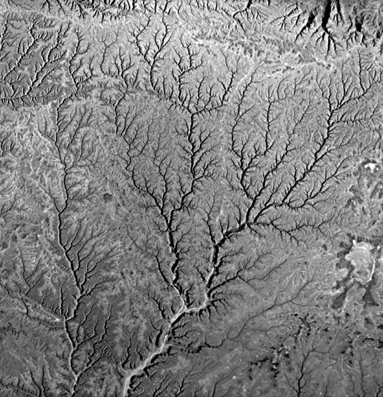 |
The Landsat scene to the west (E-2362-06242-5) shows the headwater areas of the Wadi Masila (Figure F-5.1). This image, from January 19, 1976, shows the continuation of the drainage along the prominent open syncline in the relatively resistant Jeza Formation. The Wadi Masila derives sufficient flow to maintain irrigated agriculture in the narrow valleys of the right-center image. Upstream of this point, the valleys are much broader, and the drainage is named Wadi Hadhramut. In the left center of the image, the valleys have been widened, and the Wadi Hadhramut actually opens farther westward into the Rub´al Khalí Basin. This unusual valley widening in a headwater area results in a continuous lowland, the Ramlat Sab´atayn, connecting the Rub ´al Khalí to the Wadi Hadhramut.
It seems probable that much of the well-developed dendritic drainage of the Hadhramut Plateau (seen from the Space Shuttle, Figure F-5.2) is relict from past wetter conditions, perhaps extending to the Tertiary emergence of the landmass. As the climate changed to an arid one, perhaps in the Early Pleistocene, processes of slope retreat came to dominate along the western margin of the plateau. As interfluves were destroyed, the western drainage divide of the Wadi Hadhramut/Wadi Masila system was breached. The upstream part of the system experienced pronounced valley widening by lateral slope retreat away from the relict drainageways. The Ramlat Sab´atayn is a desert piedmont etched from the former dendritic pattern of a fluvial landscape.
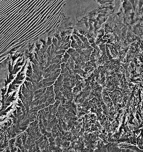
The Landsat scene to the northwest (Figure F-5.3) was imaged on January 19, 1978. It shows several northward-flowing drainages, including Wadi Aywatal Sayar, flowing from the lower left to the zone of linear sand dunes in the sand sea of Rub´al Khalí (upper left). Note that Wadi Aywatal Sayar is probably a smaller example of the drainage transition noted above for the Wadi Hadhramut/Wadi Masila system. Slope retreat has widened the valley floor, isolating a plateau underlain by the Jeza Formation at the left center when the drainage divide was breached. The Wadi Aywatal Sayar is now a continuous lowland, an extension of the Rub´al Khalí desert floor.
| Figure F-5.3 | Figure F-5.4 |
|---|---|
 |
 |
Another major drainage, the Wadi Makhya flows from the lower left of the image (Figure F-5.3) to a great floodout fan that deflects the linear sand dunes at the top center. Note that this drainage on the Jeza Formation is well developed and dendritic. The drainage on the right (eastern) part of the image is the Wadi Khudra. Note that this area of Rus Formation evaporites has a rather poorly defined pattern of dissection. Highly tortuous meandering channels occur at the right center of the image. Dissolution of Rus gypsum units during wetter climatic conditions may have contributed to the striking patterns.
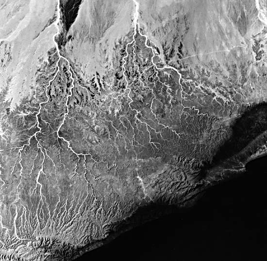
Farther to the east, in the Zufãr Region of Western Oman (Figure F-5.4), almost the entire ephemeral drainage is inland toward the southern edge of the Rub´al Khalí. The headwaters of these streams in places have nearly reached to within 20 to 30 km of the coastline. From there, short streams cutting into the dissected plateau terrain form a second set of drainage channels that in places have not yet been captured by the interior system. Landsat 1167-06324-6, October 3, 1973.
Continue to Plate F-6| Chapter 4 Table of Contents.| Return to Home Page| Complete Table of Contents|