 |
 |
|---|---|
| Plate C-1 | Map |
 |
 |
|---|---|
| Plate C-1 | Map |
The western side of the Korean peninsula is a Cretaceous granitic batholith intruded into Paleozoic metamorphic rocks. All the rocks are coarsely crystalline and weather to sand- size detritus called grus. Weathering is deep, with residual subspherical masses of relatively fresh granite forming hilltops above boulder-strewn slopes down into sandy river valleys (Figure C-1.1). Rivers are braided to carry massive bedloads. After centuries of deforestation and a recent war, erosion is a major problem. Summer monsoon rains cause avalanches and mudslides on many slopes. Valley floors are almost completely terraced into rice paddies.
| Figure C-1.1 |
|---|
 |
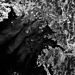
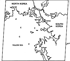
The Yellow Sea coast is known for its high tides, which reach 12 m near Inch'on (A). Ships enter tidal basins at high tide and, after the massive gates are closed, unload safely at dockside. Low tide exposes several miles of mud flats far offshore from the basins. Powerful tidal currents ebb and flow among the offshore islands and into the river-mouth estuaries. Sea walls and dikes have permitted reclamation of much rice paddy land from former tidal flats in smaller valleys. In fact, the coast has been extensively straightened by dikes most of the smaller valleys. Salt is reclaimed from evaporation basins behind sea walls, producing white rectangular patches (B).
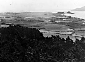
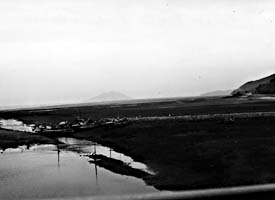
Most of the Yellow Sea is less than 60 m deep. Although the tide range is as high as anywhere in the world, wave energy on the west Korean coast is low because of the shallowness and restricted area of the sea. Only a few sandy beaches have formed to bridge the headlands and islands. Most of the sand derived from the erosion of the granite mountains is trapped in deltas at the heads of estuaries. In spite of the strong tidal currents, low wave energy and the deeply embayed nature of the coast combine to inhibit longshore sand movement that would develop beaches, although vegetated sand dunes are formed in places (Figure C-1.2). Extensive intertidal mud flats extend far offshore (Figure C-1.3).
This is a type of ria or drowned coast (Guilcher, 1976). During glacial times, river valleys extended out across the floor of the Yellow Sea. Although the old river valleys have been extensively filled by sediment carried by submarine currents in postglacial time, they can be traced in submarine seismic profiles.
During full-glacial times of lower sea level, the Korean peninsula was united to the Asiatic mainland to the west by the nearly complete draining of the shallow Yellow Sea. The climate became much more continental, with extremely cold winters. All of South Korea shows the evidence of a former periglacial climate at sea level (see Plate C-6, West Falkland Island), even as far south as latitude 35° N, almost two-thirds of the distance to the Equator from the North Pole. This harsh climate created frost-shattered sheets of rocky rubble on all slopes. Many coastal cliffs are cut into this periglacial debris rather than into bedrock. During low sea level, the exposed floor of the Yellow Sea was a vast plain of silt, carried from the China mainland by the Yellow River (out of view to the west). Both the sea and the river are named for their massive muddy sediment load. This river is said to be 40 percent mud by weight in times of flood. The exposed seafloor plains and the cold westerly winds from Siberia combined to create massive glacial-age dust clouds over Korea. Windblown silt (loess; see Chapter 8) draped the hills of the peninsula and washed back down to mix with the coarse solifluction debris. The modern rivers carry this mixture back to the coast, where the flat sediments show the complexity of their polygenetic sources.
| Figure C-1.2 | Figure C-1.3 |
|---|---|
 |
 |
Tidal currents of 15 km per hour scour constricted channels between islands and in river mouths, but when the currents slacken at each high tide, there is an interval of up to 1 hour when mud can settle onto the flooded tidal flats. During the next low tide, these new layers of mud can become sun-dried and hard or can be attached to a sticky algal layer on the mud surface. The tidal flats accreted upward to near high-tide level even while deep channels are eroded among them by ebbing and flooding currents. Relatively clear ocean waters along the axes of the tidal channels are clearly visible on the image (C). Plumes of muddy water swirl over the shallow interchannel areas.
Seoul, a city of at least 8 million people, fills the valley floor of the Han River about 16 km inland from its seaport, Inch'on. The river valleys are useless for dock facilities because of the powerful tidal currents, shifting gravel bars, and submerged mud flats. Landsat 1100-01453-5, October 31, 1972.
Continue to Plate C-2| Chapter 6 Table of Contents.| Return to Home Page| Complete Table Of Contents|