 |
 |
|---|---|
| Plate C-17 | Map |
|
|
|---|---|
| Plate C-17 | Map |
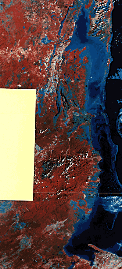
This false-color mosaic of three Landsat images covers the entire 230-km Caribbean coast of Belize (ex-British Honduras) from the Mexican border in Chetumal Bay on the north to Cabo Tres Puntas, Guatemala, on the south. Also shown at the right center is the Turneffe Islands, one of three atolls in the Caribbean seaward of the Belize barrier reef. This is the longest continuous coral reef in the Atlantic basin.
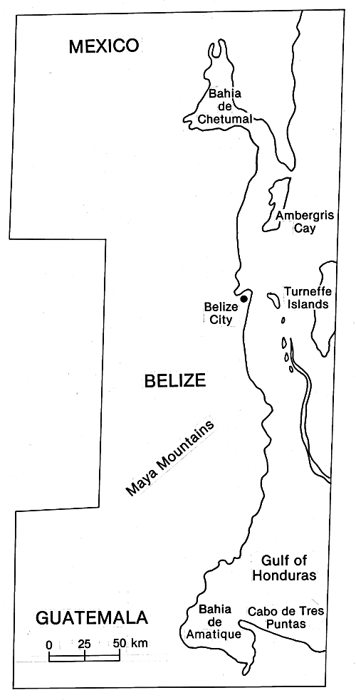
The continental shelf on which the Belize reefs are built is narrow (only 15 to 25 km in width) and tectonically active. North of the capital city of Belize, the northern shelf lagoon is generally less than 6 m deep; to the south of Belize city, the central channel of the southern shelf lagoon deepens to nearly 30 m (Purdy, 1974, p. 34). Chetumal Bay and the northern shelf lagoon are separated from the open sea by a long peninsula and a line of barrier islands (Figure C-17.1).
| Figure C-17.1 | Figure C-17.2 |
|---|---|
 |
 |
The southward deepening of the shelf lagoon and the progressive drowning of the outer platform suggest tectonic rotation down to the south. The modern reefs grow in the lagoon and on the distinct outer or barrier platform, which is a few kilometers wide (Figure C-17.2 and Figure C-17.3). Both the barrier platform and the modern barrier reef on its seaward rim terminate in a J-shaped landward hook at the southern end of the reef tract. Seaward of the barrier reef, the water plunges to a depth of 180 m. During times of maximum glacial ice, when sea level was about 120 m lower than at present, the wall-like emerged margin of Turneffe atoll would have faced westward across a narrow channel to an equally steep emerged scarp on the outer platform barrier reef.
Unlike oceanic atolls such as Jaluit (Plate C-19) or the Great Bahama Bank (Plate C-16), the Belize reefs are not built on a thick accumulation of limestone on a subsiding platform. Rather, detrital continental shelf sediments have built the narrow shelf, with quartz sand dominating the mainland side of the shelf lagoon, clay-rich mud on the outer side of the lagoon, and carbonate mud on the shelf platform. On this "siliciclastic" foundation, the reefs have grown in relatively recent time, perhaps only in the Late Pleistocene (Choi and Ginsburg, 1982). The noncalcareous subreef sediments are exposed in the northern shelf lagoon and have been encountered in shallow borings under reefs the southern shelf lagoon, seemingly confirming the recent southward tectonic tilt. One theory is that the former narrow continental shelf was largely subaerial, with fluvial sediments and landforms such as natural levees, deltas, and point bars on a floodplain. When this landscape subsided tectonically into the shelf lagoon, the higher parts of the fluvial landscape become the loci for initial reef growth (Choi and Ginsburg, 1982). Apparently, the outer barrier platform had a longer history of reef growth.
| Figure C-17.3 |
|---|
 |
An alternate hypothesis for the distribution of modern reefs in the shelf lagoon and on the outer or barrier platform is that the modern reefs are growing on fault-controlled blocks of karst- weathered older reef limestone (Purdy, 1974). The intricate distribution of small shelf atolls inside the southern barrier reef suggests that their foundations were older limestone that, when exposed to humid tropical weathering during times of low sea level, was weathered into a maze of karst pinnacles and blind valleys. Seismic profiling and a few boreholes have confirmed that the modern reef is quite thin and closely reflects the relief of the substrate.
Both alternate hypotheses probably have some truth. The older siliciclastic foundation deepens to the south, and Holocene reefs are thicker to the south, supporting the idea that a former coastal plain has differentially subsided. However, if a former reef had been built during the last interglacial time, about 125 000 years ago, that reef would have subsequently died and been subaerially exposed by low sea level until only a few thousand years ago when the postglacial sea level again rose. If the weathered karst landscape on the old reef had subsided tectonically at the rate of only a few meters in 100 000 years, it would be covered by the modern sea, and corals would have found abundant surfaces on which to reestablish. Although corals are flourishing on the Belize reef today, it is probably not a very old landform. Landsat Mosaic.
Continue to Plate C-18| Chapter 6 Table of Contents.| Return to Home Page| Complete Table of Contents|