 |
 |
|---|---|
| Plate C-22 | Map |
|
|
|---|---|
| Plate C-22 | Map |
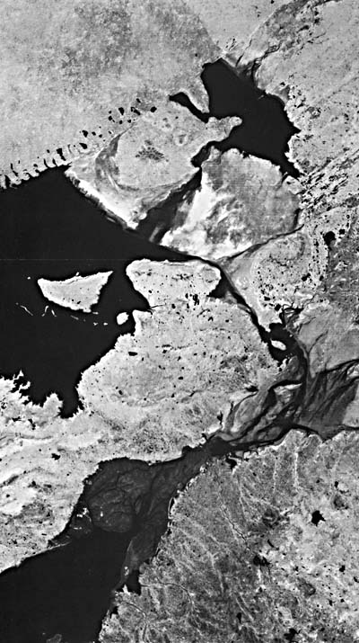
This two-frame mosaic shows both the Little Rann of Kutch and its larger counterpart, the Great Rann of Kutch, to the north-northwest. These coastal features consist of large low-relief plains on the southeastern flank of Pakistan's Indus River delta. These plains are separated by hills of pre-Quaternary rocks (A). The Great Rann of Kutch is on the Pakistan/India border just east of the India distributary mouths. The Little Rann of Kutch is located between the mainland of Kutch, forming the northern border for the Gulf of Kutch and Kathiawar to the south.
The Ranns of Kutch are believed to have a structural origin that has controlled their location. Faults that influenced the alignment of the pre-Quaternary rock outcrops trend west- northwest. Another family of faults, of which the Gulf of Kutch may be an expression, trends north-northeast. The aforementioned outcrops are thought to be horst blocks cut into segments by the north-northeast faults, while the Ranns themselves probably represent grabens. These tectonic depressions were once shallow marine gulfs after the last postglacial rise in sea level. Changes in nearby river courses (Indus, Nara, and other rivers of the western part of the Indo-Gangetic plain) caused the Ranns to become infilled with deltaic sediment, and they are now essentially broad salt-covered supratidal areas (sabkhas) that are inundated only part of the year (Glennie and Evans, 1976), as in this Plate image.
In lowland areas such as the Indus Delta to the west, the monsoonal cycle plays an important role in supplying water and sediment to the coastal plain. For the Ranns of Kutch, annual flooding by marine water and freshwater runoff from surrounding highlands occurs during the Southwest Monsoon, when marine water is forced up into the area by persistent strong winds. Including the Great Rann of Kutch, more than 30 000 km2 of lowlands are flooded annually. Most of this area is supratidal or above the normal high tide. However, when winds of the Southwest Monsoon, which blow from July to September, push marine water into the Gulf of Kutch and other estuary mouths along the coast under these conditions, salt water can be more than 2 m deep on the supratidal surface (B) (Platt, 1962). During this same period, rainfall in the area is maximized when moisture from the Arabian Sea is transported inland. Annual rainfall over the Ranns of Kutch ranges between 20 and 38 cm/yr, most of which falls during the Southwest Monsoon months. During these high-rainfall months, a number of small rivers to the east bring both terrigenous sediment and fresh water to the eastern parts of the Ranns. Hills around the Little Rann of Kutch display an intricate drainage network (C), activated primarily during the Southwest Monsoon. The remaining months of the year are characterized by the high average temperatures and low humidity of a desert environment. Therefore, as the Southwest Monsoon subsides, waters recede from the supratidal areas, allowing the Ranns of Kutch to become regions of intense evaporation and subsequent deposition of evaporite minerals such as halite and gypsum typical of coastal sabkhas (Figure C-22.1). These surfaces of salt deposition (D) are clearly visible in this figure as white (high reflectance) areas on the scene. Figure C-22.2 is a closeup of a sabkha surface illustrating the salt deposition and desiccation cracks typical of sediments from this environmental setting. Unlike the broad supratidal plains of the well-studied western Persian Gulf, which are composed mainly of carbonate sediments and evaporite minerals, the Ranns of Kutch are accumulating sizable quantities of terrigenous clays and silts, as well as halite and gypsum. Because of the high salinities and periods of dessication, most of the organisms that contribute skeletal carbonates to many of the world's intertidal and supratidal environments are not present in this setting.
| Figure C-22.1 | Figure C-22.2 |
|---|---|
 |
 |
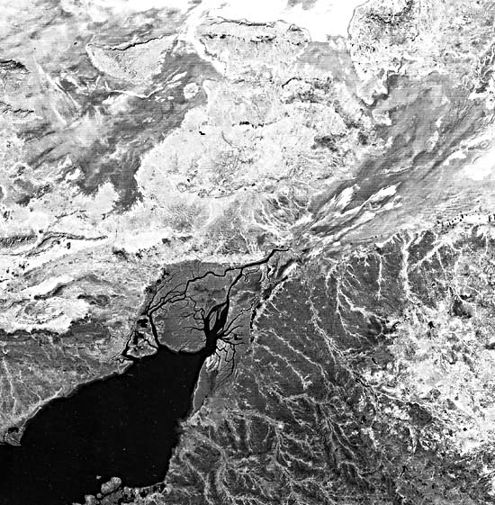
After the Southwest Monsoons, a normal semidiurnal tide of approximately 3 m forces marine waters up the Gulf of Kutch and over muddy tidal flats (E) at its head and along its flanks. These mudflats are cut by intricate networks of meandering tidal channels (F) that are clearly visible in the scene. The clay-rich sediments comprising these mudflats are transported into the Gulf of Kutch by strong longshore currents from the mouths of the Indus River, to the northwest. The greatest influx of sediments coincides with strong winds of the Southwest Monsoon. However, the flux of fine-grained sediment into the gulf, which in turn is used for tidal flat accretion, is a constant process. Local wind waves rework the outwash fans of sediment that prograde along the margins of the Gulf of Kutch, leaving narrow and poorly developed beaches (G). A similar process occurs within the Ranns themselves. As they fill with water during the Southwest Monsoon, local wind waves create shoreline features such as beaches and small cliffs (H) along the Rann margins where the distal ends of outwash fans from surrounding hills become inundated and then modified by waves. (GCW: J. M. Coleman) Landsat 2294-05024-6 and 2294-05020-6, November 12, 1975.
Continue to Plate C-23| Chapter 6 Table of Contents.| Return to Home Page| Complete Table of Contents|