 |
 |
|---|---|
| Plate C-24 | Map |
|
|
|---|---|
| Plate C-24 | Map |
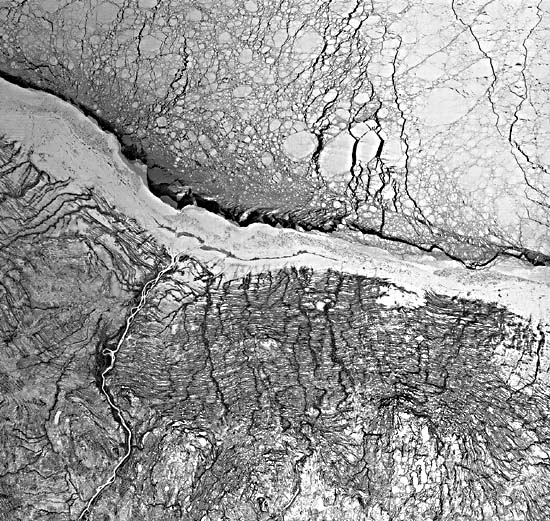
One of the most convincing lines of evidence for major shifts in sea level during Pleistocene and Holocene times comes from elevated shorelines and other coastal features such as terraces now found inland from the present land/ sea boundaries. Eustatic changes during those times are attributed to varying water volumes in the ocean basins as some of the seawater is incorporated in the ice caps during glacial advances or is returned as meltwater when glacial sheets retreat. However, shifting shorelines can also be driven by progressive rises or falls of the land surface as underlying crustal units move up or down in the gravity field in response to isostatic adjustments. One mechanism for this vertical motion stems from on-loading or off- loading of the crust by the sheer weight of overlying geologically brief masses of thick glacial ice. The sequence of shorelines along the Hudson and James Bays (Martini et al., 1980) is a classic example of the marks made by a retreating water body as the crust underneath rebounds from the off-loading of an ice sheet. In the Plate image, these multiple shores, whose positions are recorded by raised beach ridges, are brought into sharp perspective by the emphasizing effect of low Sun angle (14°) associated with the subarctic midwinter scene; in summertime imagery of the same area, these ridges are barely invisible.
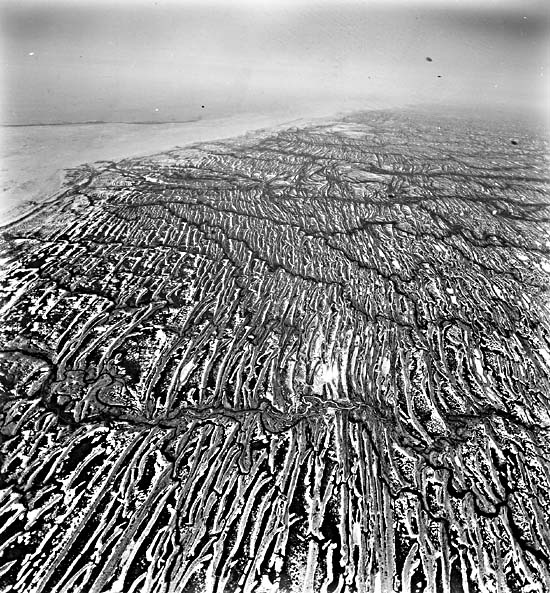
| Figure C-24.1 | Figure C-24.2 |
|---|---|
 |
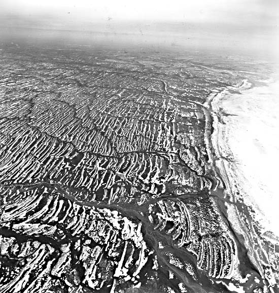 |
As the great Wisconsin ice sheet retreated across Canada, the open seas invaded low regions of northern Canada, perhaps as early as 12 000 years ago, entering from the present Hudson Straits and elsewhere. Marine water-named the Tyrrell Sea by H. A. Lee (1960)-spread over the central part of Canada, reaching a maximum extent some 8000 years ago at points 100 to 250 km inland from today's Hudson/James Bay shores. As the sea filled the crustal downwarp instigated by a major lobe of the Wisconsin glaciers, it interacted with remnants of the Laurentide ice sheet, in places producing distinctive drift deposits (washboard moraines) at contacts with the receding ice. Concurrently, the land beneath the invading sea was rising in response to the isostatic rebound accompanying ice removal. The rate of crustal uplift was fast at first, on the order of 600 cm per century (Lee, 1960), but it diminished exponentially to rates that range between 70 to 120 cm per century. Thus, the coastline has emerged rapidly, forcing the Hudson Bay waters northward, but the net shift was being counterbalanced somewhat by the meltwater rise of sea level worldwide. Radiocarbon dating of invertebrate shells in the farthest inland beach ridges indicate that those southwest of James Bay are 6900 to 7200 years old. The innermost beaches in the Fort Severn group now stand at elevations of 175 to 200 m above the current surface of Hudson Bay.
| Figure C-24.3 |
|---|
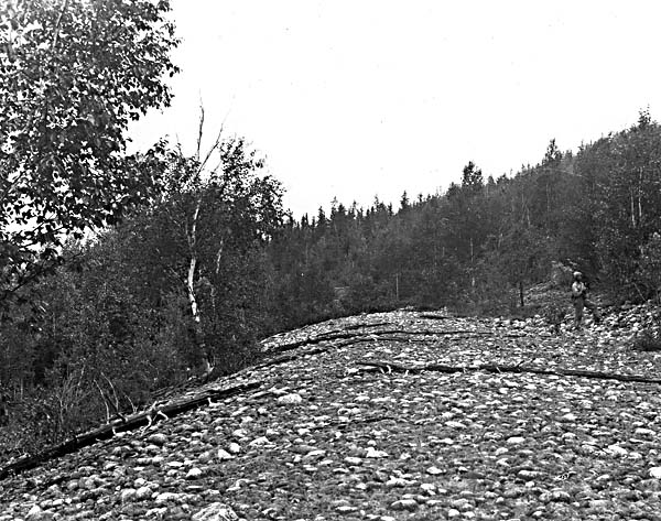 |
In the Plate scene, the area near the bottom (with ice- covered thermokarst-like lakes) is a till plateau, generally smooth and flat, with peat deposits, bogs, and fens along both elevated surfaces and drainage channels. To the north is the main zone of beach ridges. As many as 50 can be discerned from space in a 50- to 60-km wide stretch east and west of Fort Severn. These features are the dominant landform, as is evident in the oblique aerial photographs (Figure C-24.1 and Figure C-24.2). The ridges, some 100 to 200 m in width, attain heights up to 7 m (Pala and Weischet, 1982). Spacing between ridges is greater, and those lower areas are typically filled with dark peat deposits. Close examination of a ridge in situ (Figure C-24.3) indicates it to be a mixture of cobbles, gravel, sand, and blue clay, representing the reworking by wave action of the till plains materials over which the sea regressed. Soils developed on the beach material (in which the exposed larger stones account for the bright reflectance in both the Landsat and aerial images) now support jack pine and spruce. Tidal flats and salt marshes persist along the present shores. (GCW: N. M. Short) Landsat 40202-16184-4 (TM), February 3, 1983.
Continue to References| Chapter 6 Table of Contents.| Return to Home Page| Complete Table of Contents|