 |
 |
|---|---|
| Plate C-9 | Map |
|
|
|---|---|
| Plate C-9 | Map |
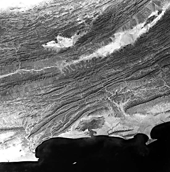
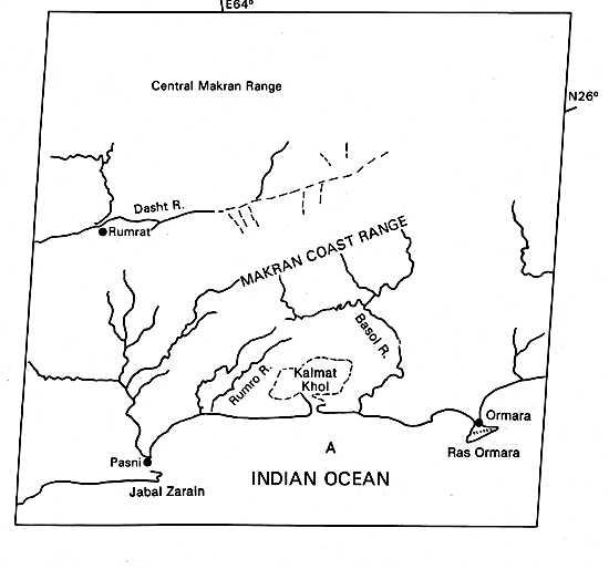
"The Makran" is a traditional name for the desert northern coast of the Gulf of Oman and the Arabian Sea in eastern Iran and Pakistan. The Makran coast is on a converging tectonic plate margin, where oceanic lithosphere of the Arabian plate is subducting under the continental Eurasian plate. This is obviously a Pacific type of coast (p. 354) with folded and faulted mountain ridges trending parallel to the present shoreline. Seaward of the Pakistan portion of the Makran shown in this image, the Arabian Plate is subducting northward at a very shallow angle of about 2°, and is dragging Tertiary marine sediments many kilometers in thickness into an accretionary prism at the southern edge of the continent (White and Louden, 1983; Platt et al., 1985). The young sedimentary rocks are being scraped off the downgoing lithosphere and crumpled against the continental margin to form the wide belt of fold mountains that dominates the image. At the present coast, the process continues; the bold headlands at Jabal Zarain, Ras Ormara, and elsewhere are upthrust fault blocks of weakly consolidated mudstones and conglomerates Miocene to Pleistocene age that are the latest increments of land to the southern edge of Eurasia. In a 1945 earthquake, several new islands emerged along the Makran coast, including one at locality A in the image that is now obscured by muddy water around (and probably over) it. The cliffs of weakly consolidated geologically young sediments are so easily eroded that some sea cliffs are dangerous to approach by ship, for fear of rock falls and slides (Snead, 1969, p. 26).
| Figure C-9.1 | Figure C-9.3 |
|---|---|
 |
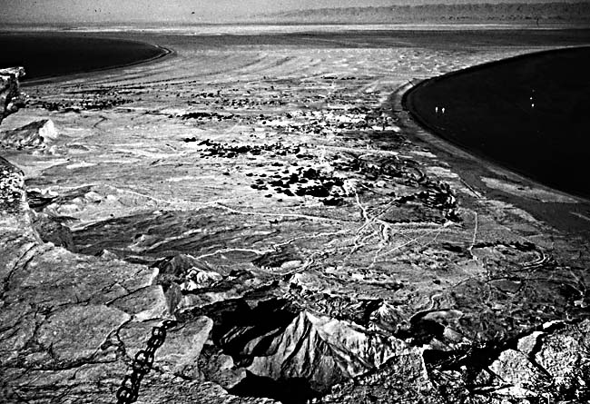 |
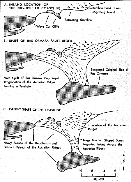
Ras Ormara is an especially interesting example of a tombolo, or sand beach, that connects an island to the mainland (Figures C-9.1). The north-facing fault scarp, 300 m in height, is clearly visible on the Landsat image. The trends of the beach ridges on the mainland show that the headland was an island several kilometers offshore, toward which refracted waves gradually built beach ridges that tied the uplifted fault-block island to the mainland. Subsequently, intense erosion, especially from strong southwesterly wind and waves, has eroded much of the tombolo (Figure C-9.2). Coastal archeologic sites tens of kilometers inland have been cited as evidence that dramatic changes in this coastal outline have occurred only in the last 3000 to 5000 years (Snead, 1967). The next earthquake could create new islands or peninsulas anywhere on the coast. Fishermen claimed that part of the coast near Pasni was uplifted 5 m during the 1945 earthquake (Snead, 1967, p. 552).
| Figure C-9.2 |
|---|
 |
Near the center of the image is a large coastal lagoon and salt flat called "Kalmat Khol." Its existence here is anomalous, for it seems doomed to be either filled in by erosion of the surrounding mountains of soft mudstones or drained by continued tectonic uplift. The Basol River to the east could be diverted into the basin by tectonic uplift, hastening the infilling.
The rapid tempo of change on the Makran coast is aided by climatic as well as geologic factors. Strong southwest monsoon winds blow steadily for several months toward this coast, causing extended periods of high water and high waves sweeping in from the southwest. The swell patterns of the southwest monsoon refract around headlands to create sweeping curves of beaches on both sides of headlands such as Ras Ormara (Figure C-9.3). The dominant beach drifting appears to be toward the east, so that the beach at Pasni, in the lee of Jabal Zarain, develops a zetaform or logarithmic spiral shape (see Plate C-2). Erosion by wind- driven waves is undoubtedly enhanced by tsunamis (seismic sea waves) such as the one 12 to 15 m in height that followed the 1945 earthquake (Snead, 1967, p. 551).
Powerful waves and currents, infrequent but intense flash floods, erodible young sedimentary rocks, and strong tectonic uplift combine to make this one of the most active and dramatic coastal regions of the Earth. Its outlines could change within the lifetimes of the readers' of this book. Landsat 1123- 05441-5, November 23, 1972.
Continue to Plate C-10| Chapter 6 Table of Contents.| Return to Home Page| Complete Table of Contents|