 |
 |
|---|---|
| Plate KL-15 | Map |
|
|
|---|---|
| Plate KL-15 | Map |
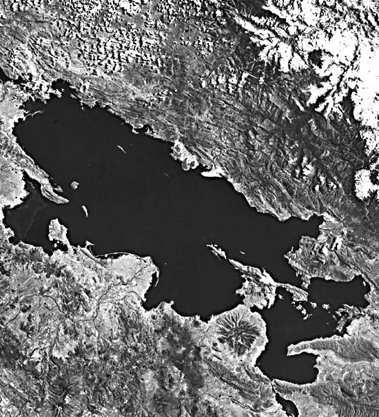
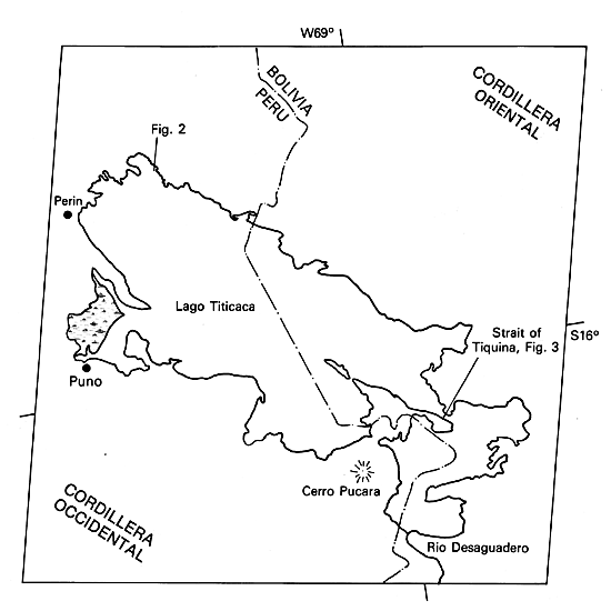
Lake Titicaca lies within a structural depression elongated in a northwest-southeast direction and represents the most northern portion of the Altiplano of Peru and Bolivia. The snow- covered mountains seen in the northeastern portion of the image are part of the Cordillera Oriental, a mass of relatively competent Paleozoic black shales, slates, phyllites, and quartzites that have been crosscut by Tertiary intrusives. To the southwest of the lake, volcanic mountains lie within the Cordillera Occidental, a volcanic plateau. Along portions of the western lake edge, Tertiary andesite and basalt flows comprise the Sillapaca Group. The Altiplano represents an alluvial-lacustrine plain overlying Late Paleozoic through Tertiary sedimentary rocks.
Lake Titicaca is considered the largest and deepest lake in the world at comparable altitudes. It occupies an area of more than 8300 km2, which is slightly less than the size of Jamaica. Its surface stands at an altitude of 3804 m, and its measured depth exceeds 300 m (Rettig et al., 1980). The lake is a freshwater body, in contrast to the Salar de Uyuni (Plate KL-13). The lake exhibits centripetal drainage and has only one outlet, the Rio Desaguadero at the southeastern end, which drains into Lake Poopo 270 km southeast of the image. Lake Poopo is one of many saline lakes on the Altiplano. In spite of receiving only 60 to 80 cm of precipitation per year, Lake Titicaca has been able to maintain its present level with only occasional fluctuations. This may be due, in part, to its receiving nearly all the precipitation during the summer. During the winter when the climate is dry, the evaporation rate is relatively low.
| Figure KL-15.1 |
|---|
 |
Lake strandlines, wave cut benches, and lacustrine sediments found about 100 m above the existing lake level are the erosional and depositional remnants of the ancestral Lake Ballivian. This Early Pleistocene lake was connected through Rio Desaguadero to the vast pre-Minchin Lake that existed at the same time to the south and encompassed today´s Lake Poopo, Salar de Coipasa, and Salar de Uyuni.
Some early investigators (Steinmann, 1929; Oppenheim, 1945) suggest a glacial origin for Lake Titicaca; however, Newell (1949), who has published the most comprehensive study on the region, finds no evidence to support this hypothesis. In fact, no glacial deposits have been recognized below 4000 m of elevation. Newell, who did his work before the era of plate tectonics, found evidence that the Titicaca trough lies between opposing sets of high-angle overthrust faults produced by compression of the deep sedimentary basin beneath the lake. The present consensus about the causes of the compression is the westward drift of the South American Plate, which overrides the Nazca Plate along the Pacific margin. The disordered structure of the region is truncated by the remarkable Puna erosion surface 200 to 300 m above the lake level. This surface cuts across Early Tertiary and other rocks. As with many mobile belts, the latest orogenic episodes have been regional uparching, accompanied by block-faulting, with volcanism and hypabyssal intrusions dominant in the Western Cordillera near the continental margin (N. D. Newell, 1984, written communication).
| Figure KL-15.2 |
|---|
 |
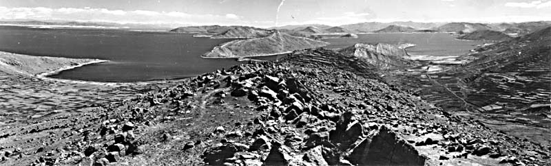
Recognition of the tectonic origin is suggested from close examination of the Landsat image. The northwest- southeast structural trend is quite evident on both sides of the lake at the northeast end. The drowned hogbacks accentuate this structural trend and indicate that fluvial erosion operated below the present lake level some time in the past (Figure KL-15.1). Further evidence of sublake level fluvial erosion is the entrenched canyon cut in bedrock at the Strait of Tiquina (Figure KL-15.2; Newell, 1949). A lower lake level evidently existed during more arid periods of the Pleistocene, probably during major interglacials.
Of interest is the oil field around Perin, which produced petroleum between 1906 and 1915 from pay horizons at 3800 m, making this the highest elevation producing zone in the world. Landsat 10443-14073-7, October 9, 1973.
Continue to Chapter 7 References| Chapter 7 Table of Contents.| Return to Home Page| Complete Table of Contents|