 |
 |
|---|---|
| Plate E-13 | Map |
|
|
|---|---|
| Plate E-13 | Map |
The Garlock fault, near the bottom of the Plate image, is generally considered to be the geologic border between the Mojave Desert and the Great Basin Desert north of the Mojave (Hunt, 1974). The Mojave, the smallest North American desert, contains vegetation found in the Great Basin and in the Sonoran Desert, but in many respects, each of the three deserts has its own distinct flora (Rowlands et al., 1982).
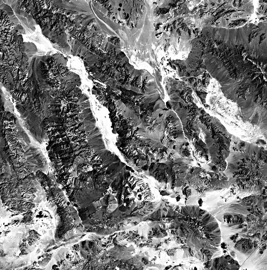
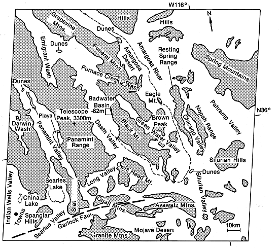
The Great Basin contains more than 150 discrete desert basins; some, like the Amargosa Desert in this scene, named individually. These basins are separated by more than 160 mountain ranges (Morrison, 1965). With three exceptions, all basins in this province presently are closed (Hunt, 1974). Four major ranges of the Great Basin are shown in this Plate: the Argus Range, the Panamint Range, the Amargosa Range, and the Spring Mountains. All are oriented northwest- southeast and have the extensive alluvial plains flanking the basins. Compare the alluvial fans on each side of Death Valley. As seen in Figure E-13.1, an aerial photograph, the fans on the western side are about 10 km long, whereas many on the east are less than 1 km wide and have fewer stream channels. The difference indicates the structural control of the basins and illustrates the relatively rapid downdropping of the eastern side.
| Figure E-13.1 | Figure E-13.2 |
|---|---|
 |
 |
Fluctuations in lake levels are indicators of climate change. Most investigators refer to lakes enlarged during the Late Wisconsinan (25 000 to 10 000 years ago) as pluvial lakes (Smith and Street-Perrott, 1983). Several basins in the Great Basin group that once contained pluvial lakes are readily picked out in this Plate because dry playa lakes now occupy their centers. In the Late Quaternary, these lakes were members of a chain referred to as the Owens River system (Smith and Street-Perrott, 1983). The Owens River transported most of its water from the Sierra Nevada to Owens Lake, approximately 40 km west of Darwin Wash. After Owens Lake filled, water overflowed to China Lake in Indian Wells Valley. When filled, China Lake overflowed into Searles Lake (Smith, 1979).
The overflow from Searles Lake traveled south around Slate Range, then north into Panamint Valley where a 280-m deep lake formed during the most intense pluvial periods. Panamint Lake spilled into Death Valley via Wingate Pass, now a long dry wash between the Panamint Range and the hills south of the range. East of Death Valley, water from the ephemeral Amargosa River drains into the valley today, as it did in the past. The channel is marked on the index map near its center and is easily traced on the TM image.
| Figure E-13.3 | Figure E-13.4 |
|---|---|
 |
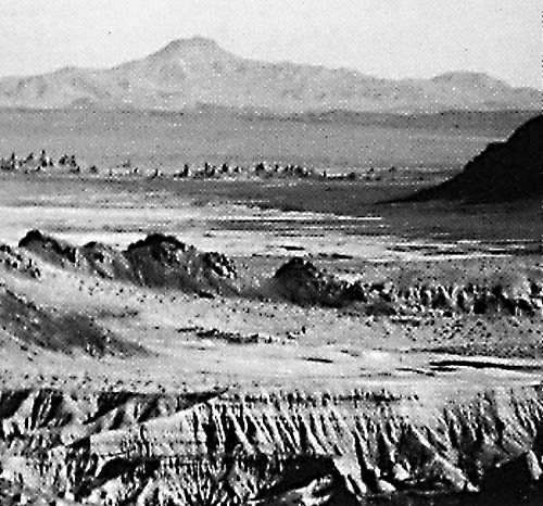 |
Badwater Basin, in the center of Death Valley, has an elevation of 86 m below sea level, the lowest elevation in the United States. Telescope Peak, about 20 km southwest of Badwater Basin, has an elevation of 3368 m. The striking contrast in local relief is indicated by the visible changes in the vegetation and geomorphology. Figure E-13.1 is a vertical aerial photograph of a 54-km wide area in Death Valley. The floor of the 5-km2 salt pan in the upper center and left of this figure is the hottest and driest part of the United States.
Searles Lake is a 100-km2 dry pluvial lake. A 930-m core drilled to bedrock in the middle of the lake (Smith, 1984) recorded more than 3 Ma of change in the environment. It is the longest available record of nearly continuous deposition in a closed basin responsive to regional surface hydrologic regimes. The lacustrine deposits record nine distinct regimes. Smith (1984) notes that many coincide with changes in sea-surface temperatures in the tropical Atlantic, and possibly one or more changes in the Earth´s orbit.
| Figure E-13.5 |
|---|
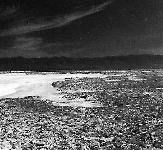 |
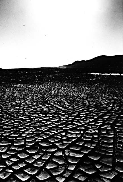
Salt bodies of Late Quaternary age in Searles Lake contain interstitial brines from which sodium, potassium, carbonate, sulfate, chloride, and borate products are extracted. Figure E-13.2 illustrates the geometric pattern of saline mud cracks at the lake. The total production value of chemicals from Searles Lake substantially exceeds $1 billion (Smith, 1979). Production continues today, and evaporation ponds and plant discharge waters are easily visible as dark pools in the northern lake area in the Plate image.
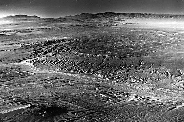
Figure E-13.3 is an oblique aerial photograph of a portion of the pluvial lake deposits in Searles Valley. Note the ancient lake strandlines in the foreground and the pluvial drainage patterns into the lake in the center of the figure. Searles Lake sediments are also visible in the foreground of Figure E-13.4. The Pinnacles, vertical tufa spikes up to 40 m tall, are in the right center. The Pinnacles are directly south of Searles Lake. Figure E-13.5 shows an evaporite pool on the left that has dried up. Remnants of the former pluvial lake sediments are on the right. The Argus Range is in the background. Landsat TM 50022-17492-4, March 23, 1984.
Continue to Plate E-14| Chapter 8 Table of Contents.| Return to Home Page| Complete Table of Contents