 |
 |
|---|---|
| Plate E-23 | Map |
|
|
|---|---|
| Plate E-23 | Map |
The 42 700-km2 Tengger Desert is one of three deserts on the Alashan Plain in central China. The Tengger is in the upper half of this Plate. The Qilian Mountain range in the bottom half of the image is the southern boundary of the Tengger. The large river passing through the mountains and then through the Tengger is the Yellow River. Landsat-3 experienced an MSS line-drop problem late in its mission, and only the right two-thirds of this image was produced.
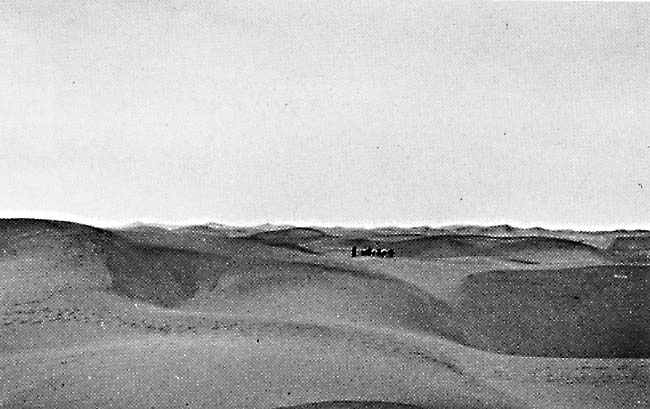
The wind in the Tengger is primarily from the northwest, and the dunes are moving toward the Yellow River. Only 7 percent of the dunes are fixed (Zhu et al., 1980). In the MSS rendition, this area of the Tengger appears to consist of sand sheets. Field investigations, however, reveal that these sand sheets are actually fields of small (5 to 10 m) complex crescentic dunes (Walker, 1982). The four people in the center of Figure E-23.1 are returning from a 3-day trip to a playa close to the center of the Tengger (slightly northwest of this Plate). At the playa, they collected a supply of salt for their village.
| Figure E-23.1 | Figure E-23.2 |
|---|---|
 |
 |
The Shapotou Desert Research Station, north of a bend in the Yellow River near the center of this Plate, was established in 1956 by Academia Sinica to develop and monitor methods to protect a major east-west railroad where it passes through the Tengger. The railroad is the dark line north of the river on the Plate. More than 40 km of track of this railroad are in the Tengger where dunes are moving as much as 15 m per year toward the southeast. The track has been buried by sand several times in the past, resulting in serious accidents.
The research station personnel manually leveled dunes to provide experimental agricultural plots. Soil and plant analysis laboratories were built to monitor land changes. Engineering, mechanical, and biologic methods are being studied at the station to determine how best to reduce the damage of windblown sand to the railroad. The most effective method developed thus far is to supplement a planting program by constructing l-m2 straw grids on the dunes, as shown in Figure E-23.2 and Figure E-23.3. The grid system, which is effective up to 7 years, lowers the surface wind velocity by 17 percent. Shrubs and trees planted within the grid are protected by the straw until they take root. Note in Figure E-23.3 that the grid system has changed the profiles of the dunes. Since the implementation of the grid system and planting program, the railroad has remained open, and no serious accidents have occurred.
| Figure E-23.3 | Figure E-23.4 |
|---|---|
 |
 |
Figure E-23.4 is part of an RBV image of the Tengger Desert acquired the same day as the MSS image. The Shapotou Desert Research Station is at the bend of the Yellow River on the right. The linear dune structures of the Tengger are more easily seen on the higher resolution (30-m) RBV image. The sedimentary outcrops, barely discernible in the MSS Plate image, are also better defined. Vegetation surrounding the railroad appears as a dark line parallel to the tracks. Landsat 30106-02481-7, December 15, 1980.
Continue to Plate E-24| Chapter 8 Table of Contents.| Return to Home Page| Complete Table of Contents