 |
 |
|---|---|
| Plate E-3 | Map |
|
|
|---|---|
| Plate E-3 | Map |
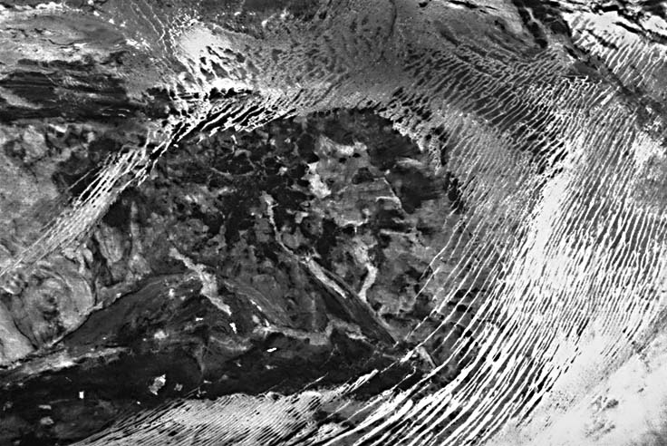
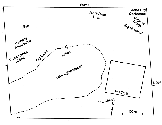
This Heat Capacity Mapping Mission (HCMM) daytime visible (Day-VIS) image shows parts of west-central Algeria, Mali, and Mauritania. In the scene, Erg Chech and the smaller Erg Iguidi and Erg Er Raoui encroach on the edges of the Yetti Eglab Massif. Erg Er Raoui is on the upper right between two dark northwest-southeast-trending hills. For convenience in comparing the Day-VIS image with the nighttime infrared (Night-IR) image in Plate E-4, point A, near the northeastern edge of the massif is marked on both index maps. Almost 15 Landsat images would be needed to cover the area imaged by HCMM. Plate E-5, a Landsat image of Erg Chech, is outlined on the right center of this HCMM image.
This Plate is in the Sahara of northern Africa. The world´s largest desert, the Sahara is approximately equal in size to the contiguous United States. About 20 percent of the desert consists of numerous sand seas, referred to by the Arabic term "erg." The sand seas are confined to basins and are separated by plateaus, massifs, and low mountain ridges (Breed et al., 1979a). Although erg means sand sea, each linear dune is referred to as an erg on some old geologic maps.
Yetti Eglab is a hilly massif composed of granite (light gray) in the west and northeast. Precambrian shield rock (dark gray) is north of the granite. The dark material in the southeast is undifferentiated Cambrian and Ordovician rock, and the center of the massif is composed of various Paleozoic shield rocks (Legrand, 1981). The small black areas on the massif are standing bodies of water.
| Figure E-3.1 | Figure E-3.2 |
|---|---|
 |
 |
The dark northwest-trending hills in the upper right make up the Ougarta Range that consists of Ordovician and Silurian rocks (Legrand, 1981). Wadi Saoura, an ephemeral stream channel, cannot be distinguished directly north of the Ougarta Range, although it maybe seen on Plate E-4, an HCMM Night-IR image.
Erg Er Raoui is a thin sand sea of linear dunes between the two series of hills of the Ougarta Range. The hills and bedrock separate it from the other sand seas. The linear sand dunes of the erg are separated by rock and gravel plains. Breed et al. (1979a) map this sand sea as complex linear dunes with star dunes on their crests.
The southwest corner of Grand Erg Occidental is on the upper right of this Plate; the erg has a very bright surface and features within it cannot be distinguished. Compare this with Plate E-4.
| Figure E-3.3 |
|---|
 |
Erg Chech, in a depression east of the massif, consists of compound and complex linear and star dunes. Rocks from the massif maybe differentiated in the interdune areas on this image. Breed et al. (1979a) measure the dunes in the erg as having a mean width of 1.0 km and an interdunal spacing of 5.7 km. They find this wide spacing unusual when compared with the linear dunes of other deserts. The regularity of the interdunal spacing of Erg Chech on the east of the massif suggests a topographical control of the dunes by jointing or faulting on the massif. Breed et al. traced the linear dunes of Erg Chech southwestward into sand seas of Mali and Mauritania. They believe that this supports Wilson's (1971) contention that dunes such as these are "sand passing" dunes that transport sand great distances from basin to basin across the Sahara. The complex linear dunes on the western flank of the massif, Erg Iguidi, rapidly die out toward the south.
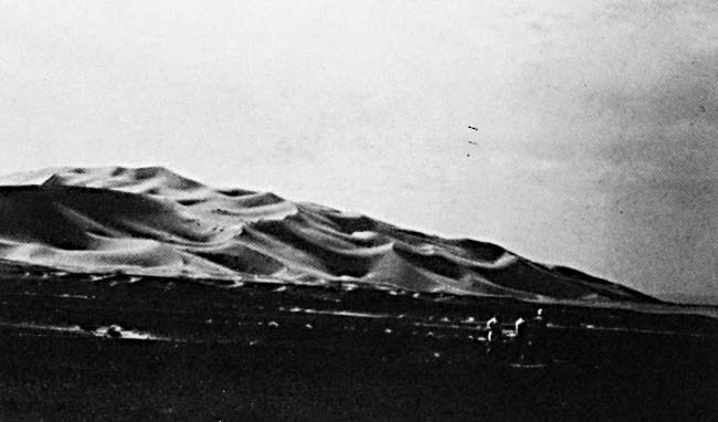
Figure E-3.1 is a hamada north of the Plate scene in Algeria surmounted by a dune field in the background. Garner (1974) examined this hamada and found that the clasts on the surface of the gravel desert are ventifacts.
A cuesta is a ramp or hill with a gentle slope on one side and a scarp on the other. The cuesta in Figure E-3.2 is northeast of this Plate near Beni-Abbes and shows linear erosion remnants from inclined Cambrian and Ordovician quartzites. Beds more resistant to erosion in the cuesta can be easily distinguished in the figure.
Compound star dunes of Algeria are visible in Figure E-3.3, an aerial photograph. Most of these dunes have four arms, and only two of the arms generally have star dunes on their flanks. The area in the foreground in this picture is a wadi. HCMM AA0309-13200-1 Day-VIS, March 1, 1979.
Continue to Plate E-4| Chapter 8 Table of Contents.| Return to Home Page| Complete Table of Contents