 |
 |
|---|---|
| Plate E-9 | |
 | Map |
|
|
|---|---|
| Plate E-9 | |
| Map |
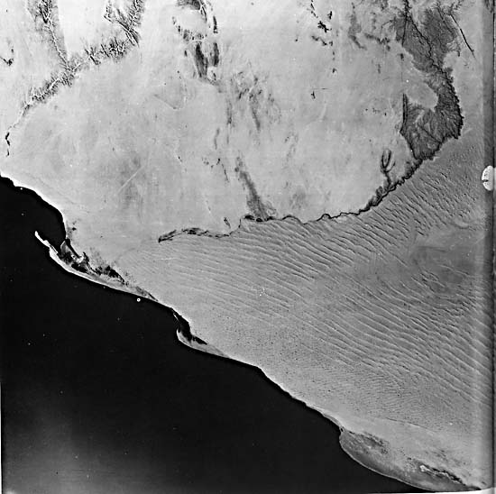
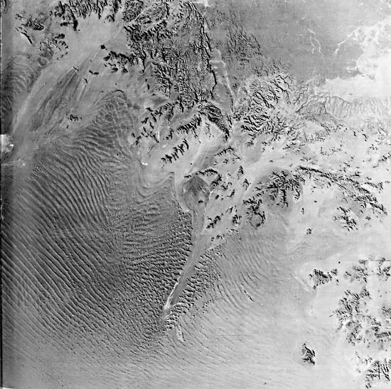
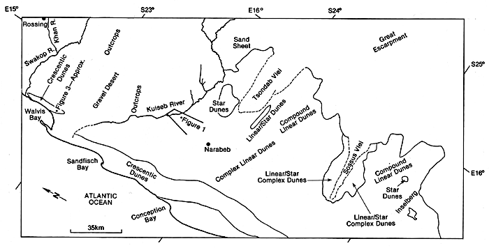
The Kuiseb River separates the 34 000-km2 sand sea in the south from the northern gravel deflation zone of the Namib Desert. Plate E-9 (two pages forward) is an LFC photograph of a 170- by 345-km area of the Namib Desert and environs. Two Landsat images (Figures E-9.1 at the north end of the LFC image and Figure E-9.2 at the south end), computer-enhanced to bring out dune details, are reproduced below for comparison. This desert is bounded on the west by the Atlantic Ocean, with its north-flowing Benguella Current that controls the arid climate of the region. On the east, 80 to 140 km inland from the ocean, it is bounded by the Great Escarpment (see Figure 1-7) along the edge of higher terrain underlain by Paleozoic sedimentary rocks. Note the drainage patterns on the western side of the Great Escarpment. Playas fed by two ephemeral stream channels, Tsondab Vlei and Sossus Vlei, develop about halfway through the sand sea.
| Figure E-9.1 | Figure E-9.2 |
|---|---|
 |
 |
As summarized by Breed et al. (1979a), many investigators believe that the desert sands are derived mainly from fluvial sediment transported to the Namib coast by a perennial river about 300 km south of the Plate. The sediments are then transported north by longshore drift. Some of the sand near the coast is of marine origin, and a little sand is brought in from the Great Escarpment and beyond.
The Namib Platform is a Tertiary erosional surface formed on schists, quartzites, and granite intrusive (Breed et al., 1979a). The platform is exposed north of the Kuiseb River in the rock desert. Roads, outcrops, gravel plains, and sand sheets may be distinguished in the gravel desert. Structures and lineaments in the outcrops are indicated by their dark features. The relief of many features on the gravel desert can be estimated using the stereoscopic capacity of the LFC. Such data on elevation differences are generally unavailable in remote corners of the world.
| Figure E-9.3 | Figure E-9.4 |
|---|---|
 |
 |
Rossing, at the southern end of the elliptical structure north of the Khan River, is the location of one of the world´s largest uranium deposits. Other minable minerals are found also in this area of the Namib. Extensive sheets of calcrete 1 to 30 m thick are exposed on the platform, leading Selby et al. (1979) to suggest that the climate has been considerably wetter for extended periods in the past.
The Kuiseb River passes through an incised valley in about the center of the Namib. Selby et al. (1979) note that the Kuiseb becomes progressively less entrenched away from the Great Escarpment. They point out that, although some flow occurs in the upper Kuiseb valley annually, it reaches the sea only once in every 8 or 9 years.
| Figure E-9.5 | Figure E-9.6 |
|---|---|
 |
 |
Selby et al. (1979) find calcium carbonate precipitates in an interdune area west of the Tsondab Vlei that they believe mark a small shallow lake, They date that lake at between 210000 to 240000 years ago. The surviving precipitates imply that the climate has been arid since then. The lake borders east of Narabeb cannot be distinguished on the LFC photograph, but it does show a large flat area with a disruption of the dune pattern that indicates the former course of the Tsondab River at the time it extended farther into the sand sea. Seely and Sandelowsky (1974) postulate that the Tsondab and other rivers from the Great Escarpment originally reached the Atlantic. The northward movement of the dunes truncated their channels.
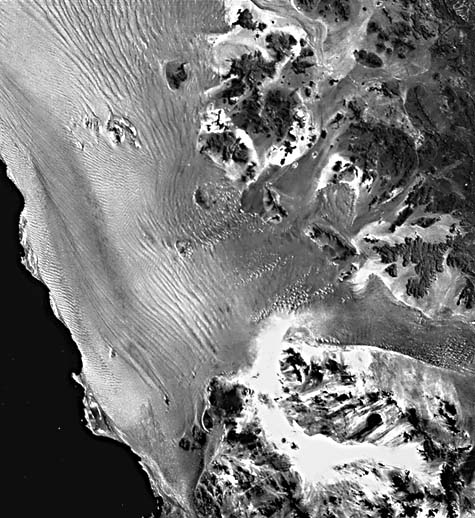
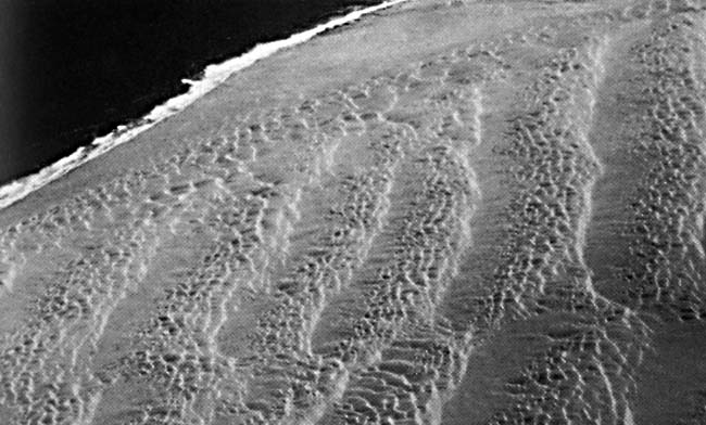
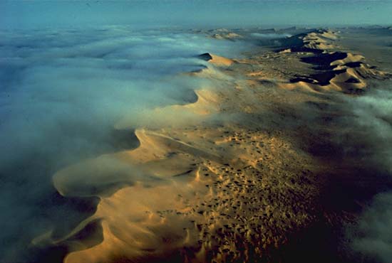
There are three main dune types in the Namib Sand Sea. Breed et al. (1979a) and Lancaster (1983) describe a 5- to 30-km wide zone of compound crescentic coastal dunes (Figures E-9.3 and Figure E-9.4). Crescentic dunes are common in coastal deserts with prevailing onshore winds. Note the two orders of ridge spacing in Figure E-9.3. In Figure E-9.4, morning sea fog, common in coastal deserts, moistens the dunes; the sea is toward the right.
| Figure E-9.7 |
|---|
 |
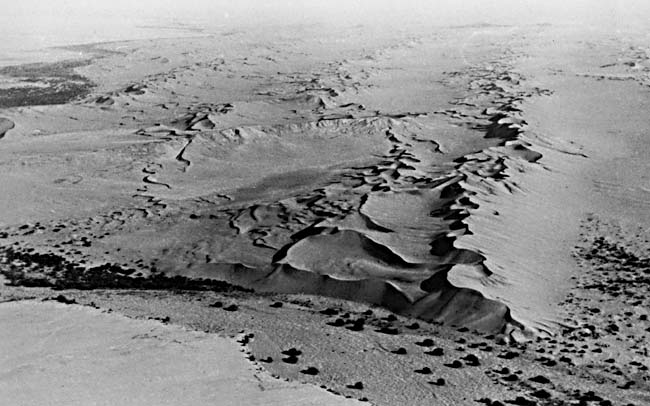
Linear dunes have formed inland of the crescentic dunes, and star dunes occur locally near the vleis. Compound linear dunes, in the Namib, consist of groupings of 3 to 5 sinuous sharp-crested ridges, each 5 to 10 m high and spaced 120 to 150 m apart. The dunes in the southern sand sea are 25 to 40 m high. Each compound linear dune set is spaced 1.5 to 2 km apart (Lancaster, 1982). Compound linear dunes are seen in Figure E-9.5, an aerial oblique view of the Kuiseb River looking south over the gravel desert and the river to the 80- to 100-m tall linear dunes of the sand sea.
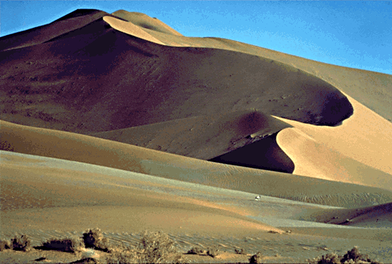
The complex linear dunes in the Plate are 50 to 150 m tall and 600 to 1000 m wide, with small star dunes and reversing dunes along their crests. Figure E-9.6 shows a large linear dune near Sossus Vlei. Lancaster (1982) notes that linear dunes in the east are effectively chains of star dunes. Below eastern slipfaces along the main ridge are small crescentic dunes that help to provide an en echelon pattern to the sinuous crest.
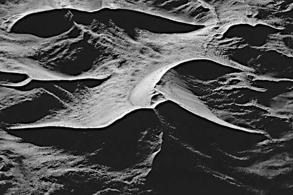
Figure E-9.7 depicts a complex star dune of the Namib. Small linear dunes are conspicuous between the two right arms of the main dune. Vegetated linear dunes to the left of this dune are encroaching on the adjacent star dune.
The influence of topography on wind pattern can be studied on the southeastern side of the inselberg directly south of Sossus Vlei at the bottom left of the Plate. Because winds there are deflected by the inselberg, the small dunes to the south reflect the complicated pattern of the wind regime. By using the stereo capability of the LFC, Walker (1985) constructed a profile of the Namib sand sea that shows a systematic increase in dune height and interdunal spacing with distance from the Great Escarpment, Large Format Camera 1917, October 12, 1984.
Continue to Plate E-10| Chapter 8 Table of Contents.| Return to Home Page| Complete Table of Contents