 |
 |
|---|---|
| Plate G-13 | Map |
|
|
|---|---|
| Plate G-13 | Map |
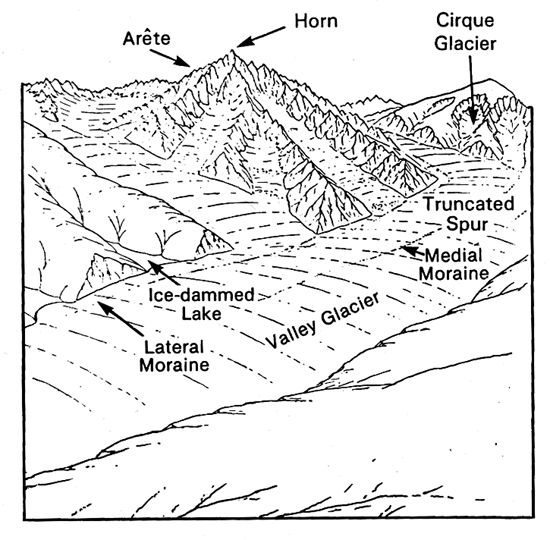
A glacial trough is "a deep, steep-sided U-shaped valley leading down from a cirque, and excavated by an alpine glacier that has widened, deepened, and straightened a preglacial river valley; e.g., Yosemite Valley, California" (Bates and Jackson, 1980). Although glacial troughs generally have a parabolic form in cross section, differential erosion by a glacier along the valley can result in a crossprofile that varies considerably from the U-shape. Embleton and King (1975a) give a thorough discussion of glaciated valleys and various theories, some controversial, about the formation of landforms associated with glaciated valleys. Linton (1963) classified glacial troughs into four major types: alpine, Icelandic, composite, and intrusive.
Figure 9-20 presents a schematic representation (from Davis, 1909) of the erosional evolution of a mountain range from preglacier to postglacier time. The left-hand sketch shows the main valley glacier and the tributaries with the same surface level. After the period of glaciation ends, the smaller tributary valleys are indicated in the right-hand sketch as suspended above the U-shaped main valley or glacial trough. The erosive power of the valley glacier also truncates the ridges between the tributary glaciers, leaving a characteristic flatiron appearance to the ends of these ridges after the valley glacier has melted (see Figure G-13.1).
| Figure G-13.1 | Figure G-13.2 |
|---|---|
 |
 |
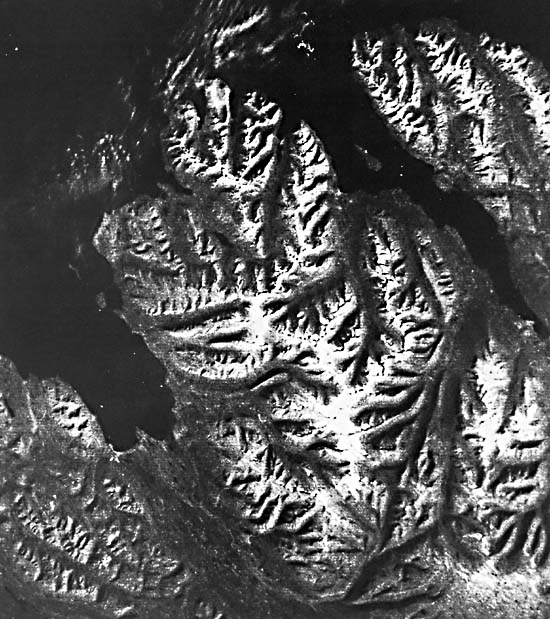
This Plate is a subscene from a Landsat image of the mountainous peninsula, Tröllaskagi, between Eyjafjördur and Skagafjördur, two of several fjords that occur along the northwest, north, and east coasts of Iceland. Tröllaskagi has more than 100 alpine glaciers, primarily of the cirque and valley glacier type (Björnsson, 1980). In the previous section on cirques and arêtes (Plate G-12), it was noted that cirques and arêtes have a distinctive pattern on satellite images of glacierized areas, and Tröllaskagi clearly shows these two landforms, as well as numerous other landforms associated with glacial erosion. All the principal types of landforms resulting from glacial erosion visible on Landsat images appear in Plate G-13: cirques (A), cirque glaciers (B), arêtes (C), hanging valleys (D), glacial troughs or U-shaped valleys (E), and fjords (drowned U-shaped valleys) (F).
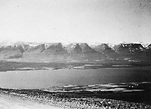
Tröllaskagi is underlain by tholeiitic plateau basalts of Tertiary age (Saemundsson, 1980) that have been subjected to repeated periods of glaciation, perhaps as many as 10 distinct glaciation if based on the stratigraphic record on Tjörnes, the second peninsula to the east (Einarsson et al., 1967). During the Late Pleistocene, Eyjafjördur and Skagafjördur were occupied by large and powerful ice streams (see Plate G-3) that flowed within preglacial valleys and drained the central northern edge of the large ice sheet that covered most of Iceland. Because the Tröllaskagi peninsula was near the northern edge of the ice cap, some of the higher ridges may have been exposed as nunataks above the surrounding ice. Smaller glaciers would have fed the larger valley glaciers from tributary valleys. Figure G-13.1 is a ground photograph looking across Eyjafjördur at a group of hanging valleys on the southeast side of Hvammsfjall, which formerly contained small valley glaciers. These small valley glaciers were tributaries to the larger valley glacier that flowed down Hörgárdalur into the main ice stream in Eyjafjördur. Eyjafjördur is a fjord (Plate G-14) or a special type of glacial trough or U-shaped valley that was further inundated by rising sea level during the Holocene. The depth of Eyjafjördur opposite Hvammsfjall, which reaches an elevation of 1000 m on the west side, is 81 m. The elevation of the floors of the hanging valleys is about 500 m, giving approximately 600 m of relief between the floors of the hanging valleys and the bottom of Eyjafjördur. The bottom of the valley glacier in Hörgárdalur, another tributary glacier to the main ice stream, would have met the main ice stream in Eyjafjördur about 100 m above the bottom of the ice stream and about 400 m below the floors of the hanging valleys.
| Figure G-13.3 |
|---|
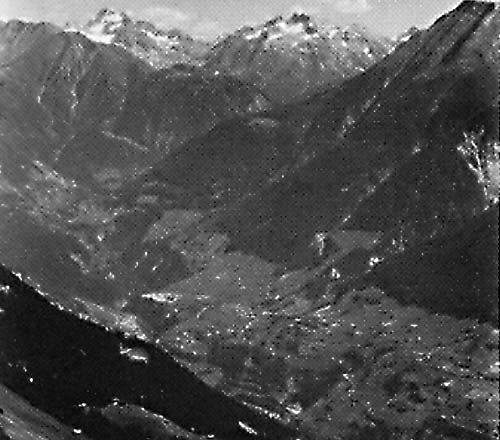 |
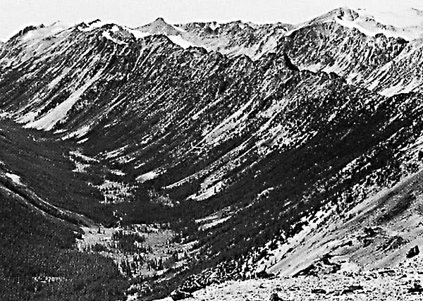
Figures G-13.2 and G-13.3 are two examples of glaciated valleys photographed in Canada and Switzerland, respectively. Figure G-13.2 shows a U-shaped valley in the Bridge River area of British Columbia. Figure G-13.3 depicts the glacially modified landscape of the Swiss Alps looking east from Riederalp, southern Switzerland, across the Rhône Valley toward Turbhorn (3244 m) and other peaks that. border Switzerland and Italy. During the Pleistocene, this compound-glaciated valley (glacial trough) was occupied by a large glacier that was fed by many tributary glaciers. The horns and arêtes in the background probably rose above the ice as nunataks (see Figure G-4.3). Landsat 22045-12124-7, August 28, 1980.
Continue to Plate G-14| Chapter 9 Table of Contents.| Return to Home Page| Complete Table of Contents|