 |
 |
|---|---|
| Plate G-16 | Map |
|
|
|---|---|
| Plate G-16 | Map |
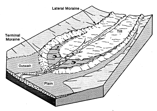
A lateral moraine is "(a) A low ridgelike moraine carried on, or deposited at or near, the side margin of a mountain glacier. It is composed chiefly of rock fragments loosened from the valley walls by glacial abrasion and plucking, or fallen onto the ice from the bordering slopes. (b) An end moraine built along the side margin of a glacial lobe occupying a valley" (Bates and Jackson, 1980).
A medial moraine is defined as "(a) An elongate moraine carried in or upon the middle (or near the margins) of a glacier and parallel to its sides (or lobes), usually formed by the merging of adjacent and inner lateral moraines below the junction of two coalescing valley (or outlet) glaciers. (b) A moraine formed by glacial abrasion of a rocky protuberance (nunatak) near the middle of a glacier and whose debris appears at the glacier surface in the ablation area" (Bates and Jackson, 1980).
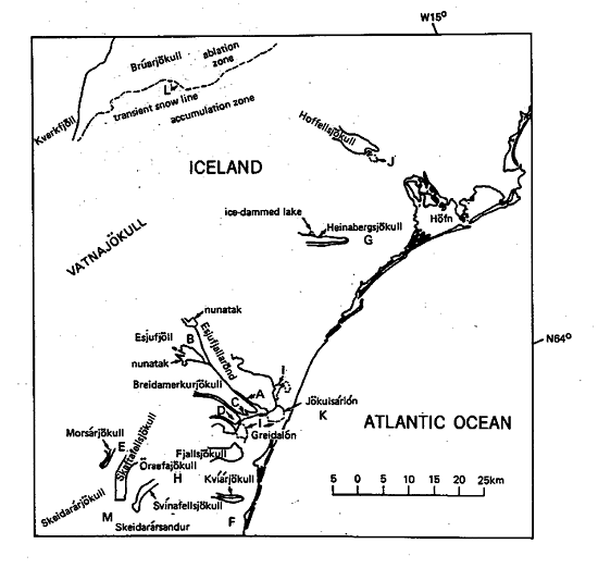
Lateral moraines (Figure G-16.1; Steingletscher, Switzerland) grade into terminal moraines at the terminus of a glacier (Figure 9-21). On Landsat MSS images, lateral moraines are difficult to delineate because they are composed of the same materials as the valley walls and thus have comparable reflectivity. The same problem exists with Landsat-3 RBV images, even with a nearly threefold improvement in pixel resolution over the MSS image (30 m versus 79 m), but the greater resolution makes delineation somewhat more probable. When Plate G-16 is viewed at high magnification, very narrow ribbons of darker material can be distinguished at the margins of the Skaftafellsjökull and Svínafellsjökull outlet glaciers (see index map). The most distinctive lateral moraines, however, are those associated with the terminus (F) of Kvíárjökull, one of the outlet glaciers from Öraefajökull in the southern part of Vatnajökull (Williams, 1983e).
| Figure G-16.1 | Figure G-16.2 |
|---|---|
 |
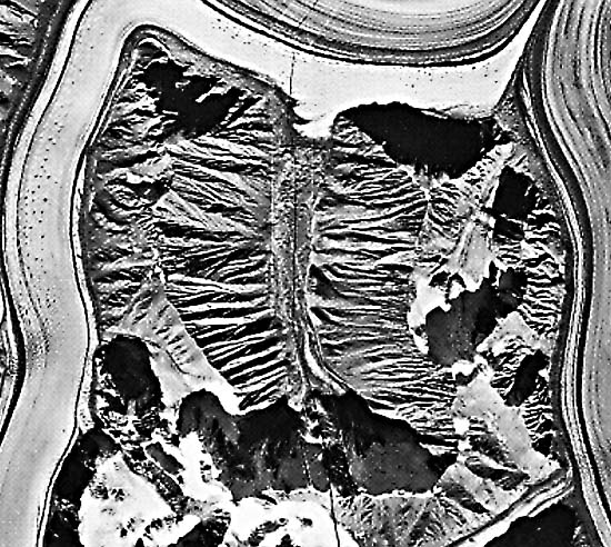 |
Medial moraines are characteristic glacier-surface features wherever two or more glaciers, valley or outlet, merge in their descent from higher to lower elevations. In this case, such a moraine represents the confluence of two lateral moraines (Figure G-16.2; Kaskawulsh Glacier, Yukon), which then continues as a medial (or interlobate) moraine (Figure G-16.3; Aletsch Glacier, Switzerland). A medial moraine is far easier to see on space imagery than lateral moraines because it is set against a high-contrast (white) background. Medial moraines are visible on several of the outlet glaciers of Vatnajökull, Iceland, especially those that flow as valley glaciers in the southeastern quadrant of the ice cap (see Plate G-6 and its index map). Of particular interest are the three pronounced medial moraines visible on the ablation area of Breidamerkurjökull, the largest outlet glacier that drains Vatnajökull on the southeastern part of the ice cap.
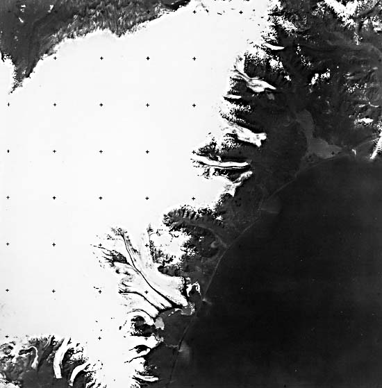
This Plate is a Landsat-3 RBV image that clearly shows the three principal and several minor medial moraines on Breidamerkurjökull. The largest medial moraine is called Esjufjallarönd (A on the index map) because it originates from two nunataks in the Esjufjöll area (B). As the glacier flows around these two nunataks, material is eroded and carried down-glacier as a medial moraine. The first segment is about 8 km long from the smaller nunatak to where it joins another medial moraine below the larger nunatak. Both medial moraines, now joined, continue for nearly 14 km to the terminus of Breidamerkurjökull. In the upper part of the glacier, the medial moraine is very narrow, only about 100 m wide. Near the terminus of the glacier, however, it broadens to as much as 1 km or more (see also Figures G-16.1 and G-16.2). Two other medial moraines of Breidamerkurjökull are visible at (C) and (D). Prominent medial moraines can also be seen on Morsárjökull (E), Kvíárjökull (F), and Heinabergsjökull ,(G). Svínafellsjökull (H), one of the outlet glaciers from the Öraefajökull ice cap, was previously discussed in the section on outlet glaciers (Plate G-6).
| Figure G-16.3 | Figure G-16.4 |
|---|---|
 |
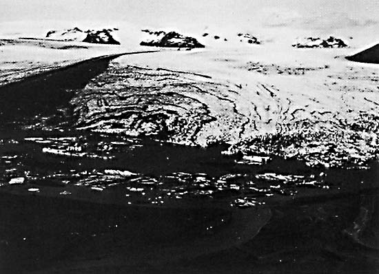 |
The outwash plain in front of Breidamerkurjökull is dominated by several large proglacial lakes (I), a subject discussed in Plate G-23. The largest of these proglacial lakes is Jökulsárlón (K), which is filled with icebergs, as can be seen on Plate G-16 and Figure G-16.4, an oblique photo that also shows part of the terminus of Breidamerkurjökull. Another large proglacial lake is also visible at the terminus of Hoffellsjökull (J). The transient snowline can be seen on Brúarjökull (L), the dividing line between the accumulation and ablation zones. (See the section on Glacier Mass Balance (Figures 9-5 through 9-9).) The upper part of the Skeidarársandur outwash plain is visible at (M).
The glacial geology of the evolving outwash plain of Breidamerkurjökull has been studied by students and faculty of the Department of Geography at the University of Glasgow, Scotland, since 1965, and this classical series of geomorphological studies (Howarth and Welch, 1969; University of Glasgow, 1982), based on geologic and photogrammetric methods, has been briefly summarized by Williams (1983 b).
Figure G-16.1 is a ground view looking southwest at the eastern lateral moraine of the retreated Steingletscher near Sustenpass, Switzerland. Figure G-16.2 is an aerial photograph of the Kaskawulsh Glacier and tributary glaciers in the Yukon Territory, Canada, showing well-developed lateral and medial moraines. Medial moraines on the Grosser Aletschgletcher (Aletsch Glacier) in Switzerland appear in Figure G-16.3. Landsat 30157-11572-B, August 8, 1978.
Continue to Plate G-17| Chapter 9 Table of Contents.| Return to Home Page| Complete Table of Contents|