 |
 |
|---|---|
| Plate G-19 | Map |
|
|
|---|---|
| Plate G-19 | Map |
According to the definition given by Bates and Jackson (1980), a drumlin is "(a) A low, smoothly rounded, elongate oval hill, mound, or ridge of compact glacial till or less commonly, other kinds of (glacial) drift (sandy till, varved clay), built under the margin of the ice and shaped by its flow, or carved out of an older moraine by readvancing ice; its longer axis is parallel to the direction of movement of the ice. It usually has a blunt nose pointing in the direction from which the ice approached, and a gentler slope tapering in the other direction (Figure G-19.1). Height is 8-60 m, average 30 m; length is 400-2000 m, average 1500 m." Bates and Jackson (1980) also define drumlinoid as a near-drumlin and drumloid-a less symmetrically formed drumlin (Figure G-19.2); a drumlin field, also known as "basket-of-eggs topography," (Figure G-19.3) is defined as "a landscape characterized by swarms of closely spaced drumlins, distributed more or less en echelon, and commonly separated by small marshy tracts."
Drumlins are composed mainly of lodgement till and are associated with till (ground moraine) (see Table 9-6 and Figure 9-22a). Thornbury (1954) notes that there are four major areas of drumlin fields in North America. Flint (1971) provides an estimate of the number of drumlins in each of these areas: in southern New Hampshire and eastern Massachusetts (3000), in New York and Ontario south and north of Lake Ontario (10 000), in Nova Scotia (2300), and in parts of Wisconsin (5000), Iowa, and Minnesota. Drumlin fields are also widespread in Europe, especially in Ireland (Figure G-19.3), Scotland, and England (Figure G-19.4), Germany, Sweden (Lundquist, 1981), and Finland. According to Sugden and John (1976), drumlins form in the marginal zone of active ice under dynamic conditions of extending flow at the glacier bed. Lundquist´s (1981) work in Sweden and Prest´s work (1968) in the Northwest Territories of Canada have shown that streamlined depositional landforms that form within the zone of active ice can be grouped into subzones. Prest´s (1968) research, as discussed by Sugden and John (1976), determined that in the Northwest Territories a zone of drumlins is succeeded by a zone of elongated drumlinoid forms, then a zone of drumlinized ground moraine, followed by a fluted ground moraine, then a ground moraine zone, and then bedrock, as depositional processes eventually give way to erosional ones.
| Fig G-19.1 | Figure G-19.2 |
|---|---|
 |
 |
Drumlin fields are well displayed on Landsat images, although Ford (1984) has reported that a drumlin field in Ireland (Figure G-19.3) is much better delineated on Seasat SAR images than on Landsat images of the same area. Slaney (1981) includes six plates in which drumlinoid landforms can be delineated. Prest (1983) and Mollard (1974) both contain excellent examples of aerial photographs (vertical and oblique for the former, stereoscopic pairs for the latter) of drumlins and drumlinoid landforms.
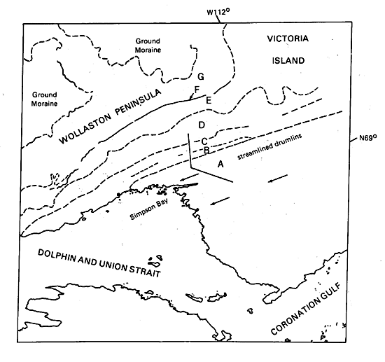
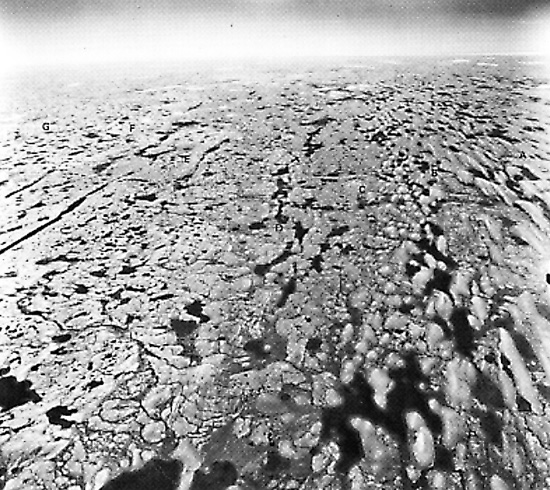
This Landsat Plate image of the Wollaston Peninsula, Victoria Island, Northwest Territories, Canada, clearly shows the full gradation of landforms from true drumlins to ground moraine in a single image. The diversity of morainal forms is evident in an oblique aerial photograph ( Figure G-19.2; approximate position indicated by a "V" on the index map) looking eastward across the morainal zones. Both this photograph and the index map show (by letters) the following features: (A) streamlined drumlins, (B) short stubby drumlins, (C) drumlinoid landforms, (D) fluted ground moraines, (E) shear moraine, (F) Colville end moraine, and (G) hummocky moraine. Arrows show direction of glacier flow (east to west). (Delineation of the morainal zones and terminology are modified from Figure 37.2 in Sharpe (1984)). The peninsula is dominated by hummocky morainal deposits onlapped near the coast by marine deposits. The region containing the image was deglaciated between 12 000 and 9 000 years B.P.; it has subsequently been subjected to 400 to 500 m of rebound (Fremlin, 1974).
| Fig G-19.3 | Figure G-19.4 |
|---|---|
 |
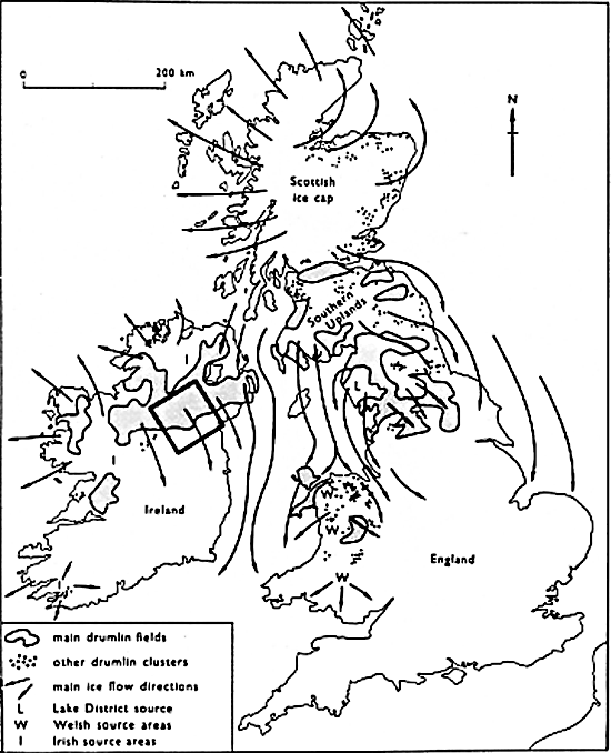 |
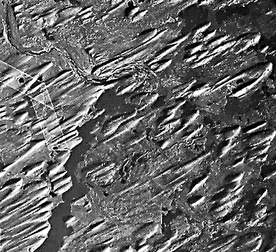
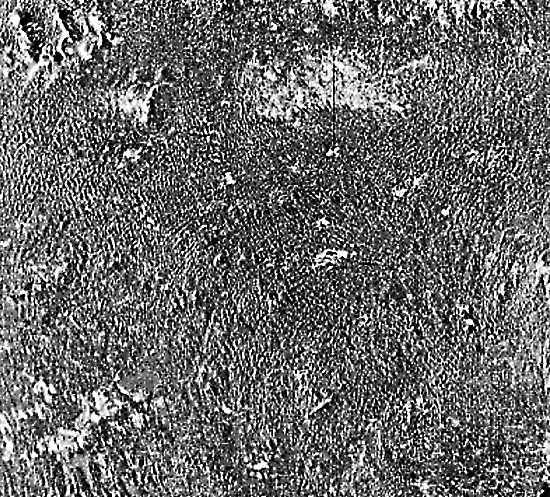
Figure G-19.1 is a vertical aerial photograph of a drumlin field with a few drumlinoid ridges and some fluting in northwest Saskatchewan, Canada. Eskers are prominent in the center and bottom left parts of the photograph. Glacier flow was from the northeast to the southwest (Prest, 1983; Mollard, 1974). Figure G-19.3 is a Seasat SAR image of part of the main drumlin field in northern Ireland. This is a classic area of "basket-of-eggs topography" and has been described by Duphorn et al. (1967), Davies et al. (1978), and Embleton (1984). As pointed out by Ford (1984), Seasat SAR images of glacial landforms have a considerable advantage over Landsat MSS images of the same area for geomorphic studies. This is primarily due to the threefold increase in spatial resolution, but in the MSS image used in the analysis by Ford, is also related to illumination angle. Ford was able to delineate four distinct classes of drumlinoid forms on the Seasat SAR image and only one on the Landsat MSS image. Figure G-19.4 (from Figure 13.8 in Sugden and John (1976) shows the distribution of drumlin fields, ice-flow directions, and sources of ice in the United Kingdom and Ireland during the last or Weichselian (Wisconsinan) glaciation. The square shows the approximate outline of the Seasat SAR image in the center of the large drumlin field in Ireland. Landsat 10371-18535, July 29, 1973.
Continue to Plate G-20| Chapter 9 Table of Contents.| Return to Home Page| Complete Table of Contents|