 |
 |
|---|---|
| Plate G-23 | Map |
|
|
|---|---|
| Plate G-23 | Map |
A proglacial lake is "a lake formed just beyond the frontal margin of an advancing or retreating glacier, generally in direct contact with the ice" (Bates and Jackson, 1980). An ice-dammed (or glacier) lake is "a lake held in place by the damming of natural drainage by the edge or front of a glacier or ice sheet, as a lake ponded by glacier ice advancing across a valley, or a lake occurring along the margin of a continental ice sheet [or ice cap]" (Bates and Jackson, 1980) (see Figure 9-22a).
Ice-dammed lakes are of interest to both glaciologists and glacial geologists, especially those involved in the study of glaciologic hazards, because of the often ephemeral nature of the ice dam. Thinning or thickening and advance or recession of a glacier will cause changes in ice dams. Some ice-dammed lakes experience annual failures in the ice dams that cause extensive flooding downstream from rapid draining of the glacial lake. Such catastrophic floods are called jökulhlaups (an Icelandic loanword meaning glacier-outburst flood) and can sometimes result in extraordinary volumes of water discharged in short time periods (see Plate F-27, which describes the Channeled Scabland of eastern Washington). Jökulhlaups occur either as the result of the failure of ice-dammed lakes (Thorarinsson, 1940) or as the result of subglacial geothermal and/or volcanic activity (Björnsson, 1975, 1976). Ice-dammed lakes are also quite common in Alaska (Post and Mayo, 197 1). Surging glaciers (Plate G-10) are especially apt to produce ice-dammed lakes because they often create ice dams on tributary valleys or by blocking main valleys (see Figure G-4.1).
| Fig G-23.1 | Figure G-23.2 |
|---|---|
 |
 |
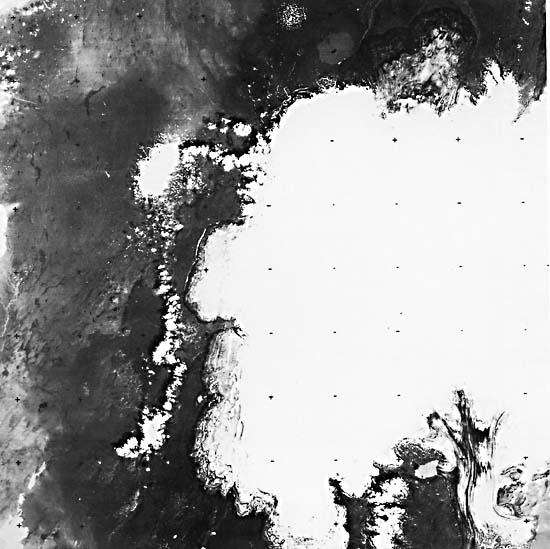
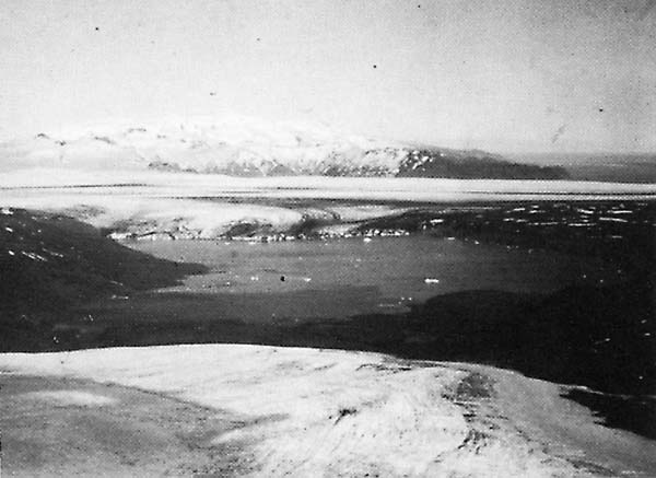
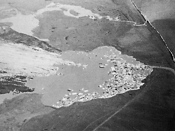
This Plate is a Landsat-3 RBV image of the western half of the Vatnajökull ice cap, southeastern Iceland, showing the prominent ice-dammed lake (Graenalón) formed by a distributary valley glacier emanating from the Skeidarárjökull outlet glacier (Figure G-23.1). Figure G-23.1 is a view looking southeast across a glacier lobe, Graenalón, the 2.5-km wide ice dam, and the lower part of Skeidarárjökull toward the ice-shrouded stratovolcano, Öraefajökull (2119 m), 50 km in the distance. Graenalón experiences an annual fluctuation in lake level, beginning with a more or less steady rise during the melt season, followed by breaching of the ice dam at its southern margin in late summer and lowering of the lake level caused by partial draining. Floodwaters from the jökulhlaup travel down the western margin of Skeidarárjökull and debouch across the Skeidarársandur outwash plain. Rist (1974), in his discussion of the August 1973 jökulhlaup from Graenalón, used successive Landsat images to calculate a 175-gigaliter reduction in volume of Graenalón after the jökulhlaup.
| Fig G-23.3 |
|---|
 |
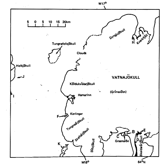
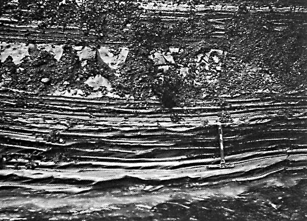
The index map for Plate G-23 pinpoints the following features: the ice-dammed lake, Graenalón (A); the ice dam (B) formed by a distributary valley glacier from Skeidarárjökull; a glacial delta (C) building out into Graenalón; medial moraine (D) on Skeidarárjökull; contorted tephra layers (E) used to calculate the rate of advance of Skeidarárjökull at 660 m per year determined from two successive Landsat images (Williams, 1983 f), two proglacial lakes (F) west of Kerlingar; two proglacial lakes (G) west of Hamarinn; an arcuate medial moraine (H) on Dyngjujökull (Plate G-16) and recessional moraines and lakes developed in ground moraine in front of Múlajökull, an outlet glacier of Hofsjökull (I) (Plate G-15 and Figure G-15.1); subtle expression of recessional moraines (J) in the outwash plain of an eastern lobe of Hofsjökull (Plate G-15 and Figure 15-2); and a former proglacial lake, Langisjór (K). Proglacial and ice-dammed lakes in glaciated areas can usually be best recognized on Landsat MSS false-color composite images by their blue color (Plate G-6). Because Langisjór does not exhibit this blue color, it can now be classified as a ground-water lake. During the summer months, proglacial lakes receive copious amounts of fluvial-borne sediment, the coarser fraction from which settles quickly to the lake bottom; during the winter months, when the lake is ice-covered (see Plate G-15), finer-grained material, the so-called glacial rock flour, settles to the bottom, giving rise to the characteristic annual varve on the lake bottom. Figure G-23.2 shows varves deposited in a late Pleistocene or early Holocene proglacial lake north of the Torfajökull ice cap, southern Iceland. Note the thicker bed of massive sand with some pebbles above the hammer that probably represents the forward edge of coarser deltaic sediments.
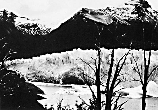
Other proglacial and ice-dammed lakes are distributed around the margin of Vatnajökull as can be seen on Plates G-16 and G-22. Figure G-23.3 is an oblique aerial photograph of proglacial lakes along the terminus of the Breidamerkurjökull outlet glacier, southeastern Iceland. The Esjufjallarönd medial moraine (see Plate G-16) is visible in the left foreground. Jökulsárlón, the largest lake, is partly filled with icebergs. Glacial rock flour gives the proglacial lakes the characteristic milky white color. A plume of glacial rock flour also colors the Atlantic Ocean, where glacial rivers from the proglacial lakes are discharging into the sea. Landsat RBV 30157-11572-A, August 9, 1978.
Continue to Plate G-24| Chapter 9 Table of Contents.| Return to Home Page| Complete Table of Contents|