
History of Remote Sensing: Multispectral Images
A significant advance in sensor technology stemmed from subdividing spectral ranges of radiation into bands (intervals of continuous wavelengths), allowing sensors in several bands to form multispectral images. This concept should be familiar to anyone who has used color filters on a photo-camera. Suppose you mount a red filter in front of the lens in a camera with black and white (b & w) film. Focused red light entering from an external object will activate the negative, leaving silver during development (hence dark), wherever those light rays strike the film. On printing to paper, dark areas produce light tones (a reversal) in the positive b & w print, so that red objects show bright (whitish) patterns that resemble their shapes. Conversely, the red filter absorbs light from green and blue objects, and therefore does not expose the negative. These areas on the film where a green object's image focuses will develop clear (no silver) and will print dark. To record green as bright on positive b & w prints, use a green to pass this color, but then it absorbs reds and blues and they will appear dark on the print. Finally, blue shows as bright shades when you use a blue filter.
Colors in color film are produced by stacking multiple layers of emulsions containing light-sensitive compounds (organic dyes) that filter out different wave lengths. In subtractive color film, the dye color are: cyan, magenta, and yellow. Using the primary colors as reference, yellow subtracts blue, magenta subtracts green, and cyan subtracts red. So, when multicolored light enters a sensor light from blue areas in the target or source, on striking the color film will bleach out parts of the yellow emulsion. The same pattern holds for green and red light, affecting the magenta and cyan layers, respectively. Then when white light passes through the multiple layers of the resulting transparencies (e.g., 35 mm slides), the now clear yellow areas will appear blue because the remaining cyan and magenta (so colored over these same areas) will filter out (subtract) red and green, leaving blue to display. The same reasoning holds for the other two primaries.
In color negative film from which color prints are made, the layer sensitive to red produces its complement color in the negative, which when printed onto paper produces red by leaving behind magenta and yellow dyes (from the [subtractive color system). We won't elaborate further on the printing rationale; suffice to say that red in print represents red from the source, green represents green, and blue represents blue. We review much more about film and camera processes in Section 10-2.
To illustrate the concepts introduced in the first paragraph, we reproduce here the same four panels used to exemplify multispectral imagery as shown on page 34 of the Landsat Tutorial Workbook. The upper left panel shows the southeastern section of the colored geologic map of Pennsylvania.
Color Photo Blue Filter Green Filter Red Filter
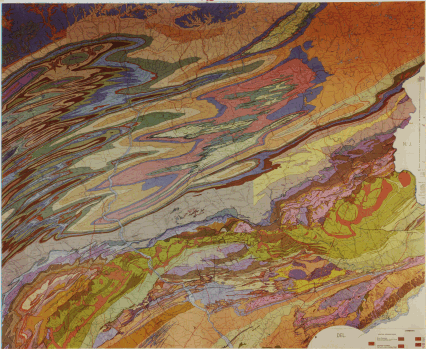
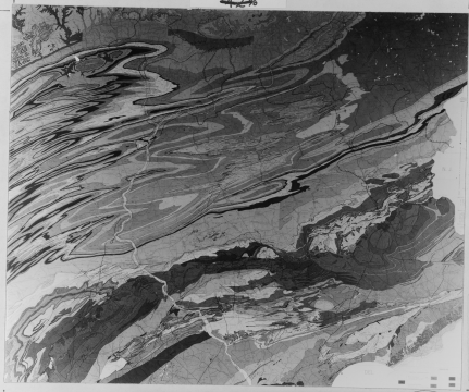
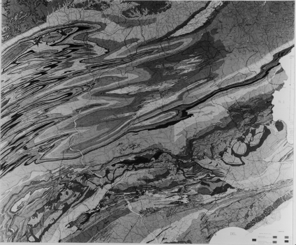
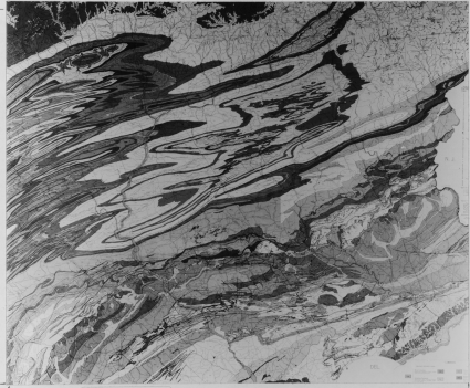
This map, illuminated in bright sunlight, was photographed three times on standard black and white film through three narrow band pass filters, centered on the blue, green, and red segments of the visible spectrum. Look first at the resulting black and white photo made with a blue filter. Light reflected from the bluer patterns in the map passed through the blue filter with high transmission (low to moderate absorption). The film negative receiving such light was exposed strongly (high silver density) and the positive print made therefrom showed the blue areas as light shades of gray. Conversely, the red and orange reflected from the map was highly absorbed by the blue filter, causing only slight densities in the negative and very dark shades in the print. Greens in the map show as intermediate gray shades in this blue-band print. We can apply the same reasoning to the green and red-band prints. Thus, red patterns displayed as light gray in the red-band print and moderate gray in the green-band print. Note that some colors tended to produce generally darker shades in all three filter prints, as for example, the dark reddish-brown zigzag pattern on the left side of the map. This darkening results in part from the inherent darkness (low level of saturation) and nature of the particular color brown ( a mix of red and yellow with black).
I-16: To check on your understanding of the explanation in the above paragraph, scroll upscreen until the color version of the map is at the upper left. Now, one at a time pick out about 5 to 7 points on this map where a different color is at each. It helps to choose each point where it is associated with a distinctive patter. Make an educated guess as to the level of gray (from white through various shades of gray to near black) you would predict when you locate each point again in each of the three color filter images. Derive a rule-of-thumb statement that summarizes what you would expect the gray level to be for each filter image. ANSWERS

Collaborators: Code 935 NASA GSFC, GST, USAF Academy Webmaster: Bill Dickinson Jr.
Primary Author: Nicholas M. Short, Sr. email: nmshort@epix.net
Contributor Information
Last Updated: September '99
Site Curator: Nannette Fekete
Please direct any comments to rstweb@gst.com.