
Lets start our feature analysis with TM band 1.
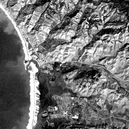
In band 1, bluish and greenish objects and areas in the scene generally show in the image as lighter gray tones than those representing other colors. In your first look at the image, you may notice the ocean on the left; hilly topography, especially in the upper right two- thirds of the scene; several areas with distinctive crisscross designs that are street patterns in the several towns; and one prominent linear feature and several similar features that are obviously a major highway and secondary roads. You may also recognize some other surface features, natural and manmade, that we will shortly explain. The dominant water feature in the scene the ocean. The tone for the open sea is surprisingly dark, inasmuch as we usually think of sea water as being bluish-green. In all bands, open water usually shows as low gray tones, since it absorbs most of the incident solar irradiation. Reflectance is greater in the blue and green bands but nevertheless is not high. But, reflectance increases somewhat if silt and other sediments are present. In this image (band 1), sediment is widespread, in the offshore water and in the bay (its tones here are the lightest of any of the bands), but deviations within the tonal pattern such as at point a, suggest variations in sediment load. Broad changes in these patterns, from the coastline to offshore locations, represent tongues of sediment (barely discernible in the aerial oblique photo) being distributed by wave action. This displays better in bands 2 and 3, where these tongues stand out in sharper contrast. Note the variable distribution of sediment within the more sheltered Morro Bay, especially at b, which is just beyond the entry point of a small river.
Right at the coastline, two very similar, but distinct, long strips of very bright (whitish) tones extend from nearly the top to the bottom of the subscene. As you examine bands at longer wavelengths, the strip on the left (to the west) will change character (becoming a mottled darker gray) whereas the one on the right stays about the same. If you are familiar with t West Coast shorelines, you probably surmised that the left strip corresponds to strongly breaking waves. These breakers are whitish to the eye when viewed from the ground, owing to their ability to scatter and reflect light, particularly at shorter wavelengths, because the water surface is no longer smooth when it churns into a foam. You may now suspect that the right strip relates to highly reflective sand that has deposited as a sand or beach bar (this coastal feature commonly results from long shore currents that cut across an inlet of shallow water [here, Morro Bay] and deposit sand. A long jetty (see aerial oblique photo ) protects the inlet from these currents. Note that this narrow structure is not visible in the image but its effect on the surf is evident. The darker patches (as at c) that interrupt this bar are coastal vegetation areas that tend to have low reflectance's in all bands, even for band 4 which renders many other types of vegetation as much brighter.
Hills and low mountains in the scene appear as a distinctive light-dark pattern that gives the impression of an irregular surface, one showing relief. Map makers create this effect by using gray-tone shading that tricks the mind into perceiving the impression of undulating topography. In this image, as in aerial photographs, the same effect is produced by variations in surface illumination. Mountain slopes (as at d) whose faces incline toward the sun, i.e., have more surface area facing the solar rays, reflect a high percentage of light towards the spacecraft's sensor (or camera on an airplane). These surfaces appear brighter (lighter tones). Slopes (e) that face away from the sun, i.e., have less surface area facing the incoming radiation, reflect most of that light away from the sensor, and thus, appear variably darker, that is, they are more or less in shadow. These slopes generally appear in medium gray patterns, within which, other patterns, representing specific features or objects, may be discernible because of tonal contrasts (look at f ). If the slopes are steep, and/or the sun angle is low, the slopes tend to appear progressively darker (approaching black tones in the imagery).
1-5: What do you think would be the effect on this subscene of having been imaged at a different time of the day; at a different time of the year? ANSWER
In this subscene, most slopes in this band and the others are very light toned. This implies a scarcity of growing (green) vegetation and thus, a predominance of bare rock surfaces. In this Fall image, the hills are in their late stage brown phase and the low chlorophyll levels reduce the reflectance from vegetation. At higher elevations vegetation is greener and denser (as at g), because more moisture is available, due to condensation of fog and local geology/topography. This denser vegetation appears in darker tones in band 1 and band 3 because chlorophyll absorbs blue and red wavelengths. In band 2 the green vegetation is only slightly darker than the dry grass in adjacent areas because chlorophyll reflects green most strongly in that part of the visible spectrum. As was evident in the oblique air photo and the ground-based photo, granite bedrock is exposed in places within the scene. The best example (at h), is Morro Rock, which is displayed in this image as a bright (sun-facing surface) spot just below a dark spot (its shadow).
Two patterns correlate with actively-growing vegetation (which appear as somewhat darker tones in the first three TM bands [especially 1 and 3] ). At (i), long thin lines of dark tones correspond to vegetation, mostly trees and bushes, that cluster along the banks of narrow, probably intermittent, streams in the hills. Other, similar tones (as at j) in more irregular patterns are usually associated with copses and irregular stands of trees, some of which are noticeable in the aerial oblique photograph. At (k) and elsewhere, primarily in the valleys and lowlands, rectangular to somewhat irregular, elongated dark-toned patterns indicate agricultural field plots containing actively growing crops (inspect the aerial oblique photograph again). Other irregular patterns in these settings (as at l), may be fields of brush or scrub (see the foreground in this photo) or even wetlands. Still other darker-toned areas, as at (m) and (n), that spread over wider expanses are either open, uncultivated or now, barren fields or lowlands that are sporadically covered with natural vegetation.
The large, roughly triangular area on which (o) is centered lies at the end of the small river (p) that winds through the valley in which Highway 1 passes. At least part of this feature is a delta that has built up into Morro Bay. The live vegetation it supports, rendered in moderately dark tones in this band, is characteristic of wetlands that develop into saltwater marshlands along a coast.

Primary Author: Nicholas M. Short, Sr. email: nmshort@epix.net
Collaborators: Code 935 NASA GSFC, GST, USAF Academy
Contributor Information
Last Updated: September '99
Webmaster: Bill Dickinson Jr.
Site Curator: Nannette Fekete
Please direct any comments to rstweb@gst.com.