
Space-based Topographic Operations
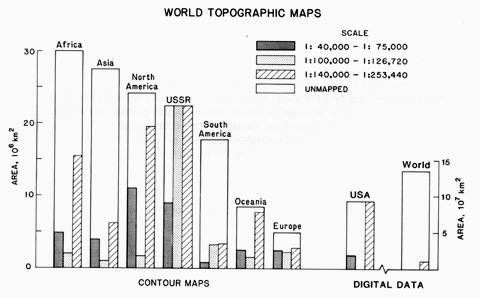
After this long preamble, we will now concentrate on the ever-expanding role of space measurements of the Earth's topography. This information has wide applications: in geology (e.g., correlating with plate tectonics effects); in geophysics (e.g, distribution of isostatic imbalances); in climatology (e.g. ocean circulation; orographic barriers), in hydrology (e.g., drainage basin characteristics); in glaciology (e.g., ice sheet thicknesses); in ecology (e.g., ecozone disposition); and in planetology (e.g., comparative global hypsometry [frequency distribution of elevations]). Many of the operations hitherto performed by ground surveying and aerial photography can now be conducted from satellites hosting instruments suited to determination of surface variations. The end result over time will be a significant improvement in the availability and quality of maps at various scales, especially for regions of the world in which these continue to be lacking. It is surprising to realize that worldwide mapping, as of 1988, is very spotty and incomplete, as evidenced in this chart:
Programs and missions have been proposed, and some are being implemented, to apply space technology to eventually acquire digital data sets that provide global coverage of elevations and positions at several scales. These would lead to topographic maps having horizontal resolutions from 100 meters to a kilometer (cell sizes) and vertical resolutions from 1 to 10 meters (contour intervals). High resolution regional coverage (on order of 100 m horizontal and 1 m vertical) is technically achievable even now. Similar resolutions are needed for sea state measurements.
Global Positioning Satellites (GPS)
An extraordinary locating technology available to everyone - including the "man in the street" - is the Global Positioning System (GPS) operated by the U.S. Dept. of Defense. This utilizes 24 (21 active; 3 as spares) small satellites each transmitting radio signals at the same two frequencies (L1 = 1575.4 Mhz; L2 = 1227.6 MHz). Each satellite follows a circular orbit inclined 55° to the equator at an altitude of 20,200 km. This constellation of satellites is placed, four each, within 6 orbital planes spaced 60° apart. In this configuration, each satellite reoccupies the same track every 24 hrs. At any instant, a signal receiver positioned anywhere on the ground (or on the ocean or in the air [the system can function in a moving platform to yield locational information and thus is suitable for navigation]) should have at least five, and up to 8, of these NAVSTAR satellites in several orbital planes in radio "line of sight", each being at some specific different distance from this station.
One advantage of relying on these outer space platforms as signal sources is that surface obstructions that would interfere with ground-based platforms are eliminated. Accurate location is accomplished by a three-dimensional variant of the surveyor's method of triangulation (fixing on three separated points). The NAVSTAR radio signals spread out in spherical wavefronts so that those from any three satellites (as points) in line of sight can be visualized as intersecting at the receiver. Its location now becomes a matter of determining the radii (distances) of the signal spheres. A fourth satellite aids in determining specific elevation, and a fifth further increases accuracy. The Russian space program has developed a similar system, GLONASS, now operational.
Location is established by pseudoranging, which determines distance to each satellite (which transmits its own unique identification as a pseudo-random-noise [PRN) code) by analyzing the radio signals that travel at the speed of light. The signal contains modulated time-tagged data bits that permit transmission (hence travel) times to be determined as the difference between time of origin and time of arrival. The position of each satellite must be closely fixed at any moment by knowing its ephemeris (orbital parameters that determine where a satellite is relative to some ground reference), which can be calculated from signals sent to a network of control stations. There must also be high precision atomic clocks (two each of cesium and rubidium) on the satellite and a corresponding clock in any ground receiver whose location is desired. Electronics and computer processing at the receiver facilitate calculation of Coordinated Universal Time (UTC) (effectively, Greenwich Mean Time) which can then be adjusted to GPS Time, so that time differences between corresponding signals from the several satellites can be determine with high exactitude.
Civilian-usable signals sent in the Coarse Acquisition (C/A) mode, confined to L1 output, are available to anyone using a receiver costing as little as $500. This setup leads to a standard accuracy of ~ 100 m horizontal and 156 m vertical. Using more expensive (up to $40,000) receivers, operating in the Precise (P) mode, L1 and L2 (the latter also is used to correct for ionospheric interference), accuracy under optimal circumstances can reach 17.9 m horizontal and 27.7 m vertical; this mode is restricted to military and approved scientific use at present. Several specialized techniques have been devised to reach this accuracy, including Code Phase Tracking (for navigation) and Carrier Phase Tracking (for surveying) which requires two receivers working in tandem; another uses differential GPS corrections. The upshot of GPS on the world stage is that ground survey points can be set up merely by aiming the receiver rather than resorting to theodolite transits (which, however, remain superior for very precise surveying). There are many entries that further discuss/describe GPS on the Internet; just enter "GPS" into your search program.
11-16: Mention two civilian uses of the global position system. ANSWER

Primary Author: Nicholas M. Short, Sr. email: nmshort@epix.net
Collaborators: Code 935 NASA GSFC, GST, USAF Academy
Contributor Information
Last Updated: September '99
Webmaster: Bill Dickinson Jr.
Site Curator: Nannette Fekete
Please direct any comments to rstweb@gst.com.