
Hurricane Andrew; 1993 Storm of the Century
We close this part of Section 14 with two special-interest stories.
In late August of 1992, Andrew, a category-five hurricane ripped through the Bahamas, slammed into southern Florida (eye over Homestead Air Force Base), and passed into the Gulf of Mexico to hit Louisiana. Although rather small in diameter, this intense storm was the most costly in U.S. history-estimates as high as $30 billion in damage-even though it took only 43 lives (a tribute to the early warning efficacy of metsat monitoring). Winds in excess of 240 km/hr (149 mph) flattened entire housing developments. This devastating hurricane got a lot of attention by a variety of sensors from above and on the ground. Consider these images:
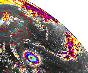
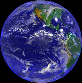
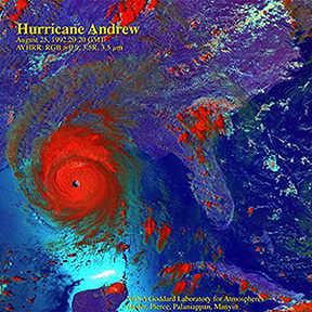
The top image from NOAA-7shows the hurricane as it strikes land in Florida, with colorized tones representing higher intensities. In the middle is a GOES-7 full-Earth, color view obtained on August 25, 1992, in which Andrew approaches New Orleans. This perspective indicates scale, showing the hurricane, while powerful as organized, was still just another mass of clouds of no greater extent than some other storm systems. But, on close-up (bottom) in the AVHRR color version (RGB = 0.9; 1.5R; 3.5 µm), the perfection of the eye and the well-developed structure of this counterclockwise-spinning, low-pressure system are obvious.
14-25: What do you think happened to Andrew after it made its second landfall around the Mississippi Delta? ANSWER
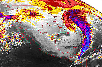
On March 13, 1993, the "Storm of the Century", shown here in this GOES-7 image, with more intense clouds (color-enhanced), struck the eastern U.S. with massive snow falls and high winds.
The writer at the time was in Bloomsburg, Pennsylvania, preparing to leave the next day to give a paper at the first Lunar and Planetary Science Conference, which he had planned to attend since 23 years earlier. It was not to be. Snow locally exceeded 60 cm (24 in), driven into deep banks by winds. All Interstate highways within Pennsylvania closed for two days.
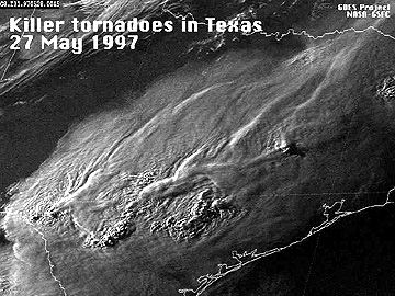
Lastly, tornadoes, while much more localized than hurricanes or subcontinental storms, can do incredible damage to the areas on which they touch down. Low pressures, and wind velocities that can exceed 200 mph, will flatten buildings (tornadoes have a special fondness for trailer parks), uproot trees, and carry objects for hundreds of feet to even miles from their spot of origin. The storms that brew them are effectively tracked by ground radar and by satellites (usually geostationary). On May 27, 1997 several lines of storm clouds bearing multiple funnel clouds crossed central Texas with deadly results. Here is a GOES-8 image of these advancing fronts.

Primary Author: Nicholas M. Short, Sr. email: nmshort@epix.net
Collaborators: Code 935 NASA GSFC, GST, USAF Academy
Contributor Information
Last Updated: September '99
Webmaster: Bill Dickinson Jr.
Site Curator: Nannette Fekete
Please direct any comments to rstweb@gst.com.