
In view of the tremendous energies involved, it is no wonder then that we classify the Chicxulub impact in the Yucatan Peninsula as one of the biggest short term natural events known in the geologic record (of nuclear-equivalent magnitude in excess of 100 million megatons). It occurred 65 million years ago and led to a 200-300 km (>150 mi) wide (there’s still some uncertainty regarding the location of the outer rim) and perhaps 16 km (10 mi) deep depression. This huge structure has no evident surface expression, being covered by younger sedimenary rocks, but does appear subsurface as a strong gravity anomaly, as shown below. It was discovered almost incidentally through oil drilling, in which core samples, containing so-called volcanic rocks (now known as shock-melted rock), showed distinct shock effects. The samples languished for years in the basement of the University of New Orleans' Geology Building, before someone re-examined them and discovered their origin.
The Chicxulub impact into shallow waters of the Gulf of Mexico generated huge waves and, even more destructive to the planet, tossed enormous amounts of rock and water into the atmosphere. These materials, in turn, caused a worldwide "cloud deck" of aerosols, gases and particulates leading to temperature fluctuations and reduced photosynthesis that wiped out much of the food chain and provided the "coup de grace" to the few dinosaur families still living then on Earth. The resulting debris that ejected into high altitudes spread around the globe and settled as a thin layer of material that marks the precise K/T boundary between the last rocks of the Cretaceous (symbol K) Period and the first sediments formed in the younger (overlying) Tertiary Period (symbol T). The deposits contain iridium, a metallic element present in some meteorites, and mineral grains that bear evidence of intense shock (see below).
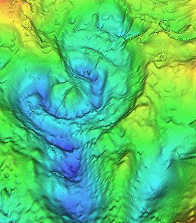
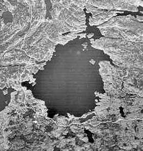
We recognize the younger, usually less eroded craters by their morphology or external form. They are approximately circular (unless later distorted by regional deformation), have raised rims, show structural displacements in their wall rocks, and may have a central peak, consisting of rocks raised from deep original positions. We can emphasize the morphology of these craters in 3-D perspectives (commonly using Digital Elevation Map data) of their contours, exaggerating the elevations and applying shading or artificial illumination (computer-controlled). Two examples illustrate how we can make craters more obvious, when today they have moderated and often have low relief. On the top is the Flynn Creek structure (3.5 km [2.2 mi] wide) in Tennessee, and on the bottom is the 24 km (15 mi) wide Ries Kessel in Bavaria:
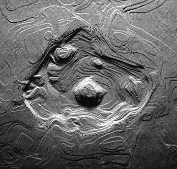
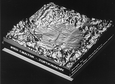
18-6: In the Ries Kessel perspective view, the crater appears surrounded by mountains. But in reality, the actual landscape is hilly but not mountainous. Explain the illusion. ANSWER
In general, craters smaller than 3-5 km (1.8-3.1 mi) in diameter lack central peaks, i.e, they have bowl-shaped interiors, and we call them simple. Most larger craters have central peaks, in which the rocks below the true crater boundary have "rebounded" upward from the collision, further aided by centripetal forces associated with crater wall slumping. We call these, complex craters, but erosion and infill may subdue the peaks. Flynn Creek, similar to most other craters in the U.S. that cut into carbonate rocks, just barely received a central peak, which still shows topographically. The Ries does not retain a morphological peak, but the depth to the crater boundary, as determined by drilling, is less in the interior.
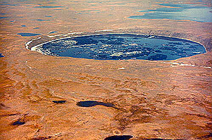
Simple craters (and some larger ones) often have depressions that fill with water. On the top, below, is the 3.5 km (2.2 mi) wide New Quebec crater in granitic shield rock, exposed in Northern Quebec. On the bottom is the much older, West Hawk Lake structure (2.5 km [1.6 mi] diameter) formed in metamorphic rocks in easternmost Manitoba (first studied in detail by the writer ).
In Canada, and other northern latitude countries, these lakes freeze in winter, allowing support for drill rigs, so that we can explore the crater infill materials by recovering core.
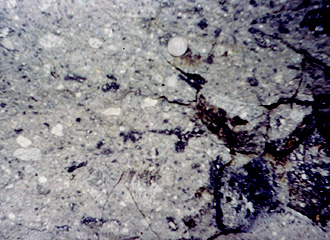
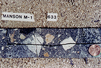
Deposits of fragmental rock surround most younger craters. An example (top, below) of such rock (termed breccias), from an outcrop at the Ries crater, illustrates these ejecta deposits. A second example (bottom) seen in core from a drilling that penetrated the Manson central peak, shows the diverse nature of the rock types making up these breccia fragments (called clasts).
18-7: Suppose a continuous length of drill core consists of first an interval of breccia much like that shown in this figures, then a 10 meter interval of a single rock type, say granite, and followed by more small fragmental breccia. What explains this? ANSWER
Eroded craters lack definitive external shapes, although the initial circularity may have a persistent effect on drainage, keeping streams in roughly circular courses. Such craters are often hard to detect but the presence of anomalous structural deformation and of brecciated rocks give clues. In rocks that were just outside the original wall boundaries, a peculiar configuration, known as shatter cones, commonly develops.
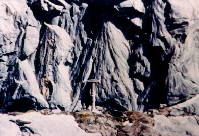
These "striated" conical structures (described as "horsetail"-like in shape) can be very small or can reach six feet or more in length, as seen above in quartzites at the Sudbury, Canada, impact structure (as an aside: the writer's "favorite" geological outcrop, anywhere, is the low bank partly around the parking lot of the MacDonalds fast food restaurant in downtown Sudbury, where excavators exposed a continuous cluster of shatter cones.). When we plot the original positions of the folded rocks containing the cones, the cone apexes invariably point toward an interior location that lies above the central crater floor.— In effect, they denote that the position where the energy was released was above the floor, a situation incompatible with a deep volcanic source, as once advocated by skeptics. The cones, which also sometimes form in rocks subjected to nuclear explosions, occur in lower (peripheral) shock pressure zones, as shock waves, spreading outward, place the rock into tensional stress. Many cones appear to originate from point discontinuities (e.g., a pebble) as though the waves were diffracted.
18-8: Try to explain what happens to cause the apex of a shatter cone to point towards the upper center of the crater near the point of impact. ANSWER

Primary Author: Nicholas M. Short, Sr. email: nmshort@epix.net
Collaborators: Code 935 NASA GSFC, GST, USAF Academy
Contributor Information
Last Updated: September '99
Webmaster: Bill Dickinson Jr.
Site Curator: Nannette Fekete
Please direct any comments to rstweb@gst.com.