
Mars, The Red Planet
We switch now to the region beyond Earth, as we explore the Mysterious Planet Mars, recently upgraded in interest because of the discovery of possible evidence of single-celled, organic matter (life?) in a meteorite (found in the Antarctic), believed to have been ejected into deep space from an impact on ancient Martian crust.
Mars mean diameter (6780 km [4875 miles) is 0.51 that of Earth; its volume is about 1/8th that of Earth. A martian day is almost the same as a terrestrial day; Mars takes 1.86 Earth years to complete its orbit around the Sun. Its orbit is distinctly elliptical (1.38 A.U. perihelion to 1.67 A.U. aphelion; average distance of 1.52 A.U.). Its rotational axis is tilted 25°, similar to Earth, which causes Mars to have summer and winter seasons. Mars has a mean density of 3.93 g/cm3 compared with Earth at 5.52 g/cm3; it likely has a much small inner core that may be iron-poor.
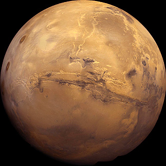
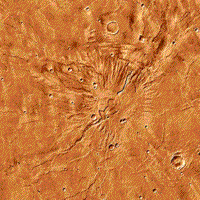
Look below at a beautiful, full-face image of a Martian hemisphere, which should make it obvious why Mars is also known as the Red Planet. This mosaic was constructed from reprocessed Viking images. Two conspicuous features, described later, are the huge gash across the face, known as Valles Marineris, and the three great volcanoes in the Tharsis group, on the left.
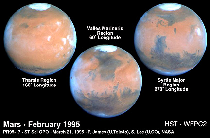
Compare this with three hemispherical views of Mars taken by the electronic camera system on the Hubble Space Telescope (HST) through filters that allow close approximations to true color. The blues along the limbs are somewhat artificial.
19-33:
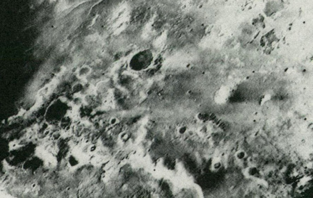
We now know a great deal about Mars from flybys, orbiting surveyors, and landings. The first flyby, by Mariner 4, on July 14, 1965, produced 22 images covering roughly 1% of the planet. Mariners 6 and 7 passed Mars on July 31, and August 5, 1969, together obtaining 199 images that extended coverage to about 10%. A typical Mariner 6 image, shows frost-covered parts of the south polar region, with dark craters, furrows, and pits.
A quantum leap in coverage followed the first successful orbiting of another planet, when Mariner 9 arrived on November 13, 1971. Returning more than 7,300 panchromatic images, a wide-angle TV camera, capable of 1-3 km (0.6-1.9 mi) resolution, mapped almost the entire surface, while a narrow-angle TV camera imaged selected areas at 100 m (328 ft) resolution. Mariner 9 also carried an IR radiometer, an IR interferometer spectrometer, and a UV spectrometer. The imaged surface qualifies Mars as one of the most diverse and spectacular planetary bodies in the solar system. Lacking vegetation and water cover, the easily seen geologic features were often grandiose in scale and sometimes unique. As with most extraterrestrial objects, their interpretation by astrogeologists started by comparing or contrasting features with those known on Earth. Martian features often required innovative explanations.
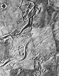
A typical Mariner 9 view, as a mosaic, shows fractures, erosion (stream?) channels, and craters.
The Russians launched Mars 2 and 3 probes to that planet in 1971, but acquired only limited data, mainly on the magnetic field. In 1973, the former Soviets sent three more spacecraft to the Red Planet. In March of 1974, Mars 4 failed to orbit the planet, but Mars 5 did, long enough to return data, including images during 10 of its 20 orbits. Mars 6 successfully descended through the thin Martian atmosphere but failed during the last second before touchdown.
The culmination of U.S. exploration to Mars began on August 20, 1975, and September 9, 1975, with the launches of Vikings 1 and 2 respectively. Their Orbiter components began orbiting the planet in late June and early August of 1976, coinciding roughly with America's Bicentennial Celebration. Each carried two identical vidicon (TV) cameras, capable of color imaging (as composites of black and white images taken through color filters) and acquiring stereo scenes at 100 m (328 ft) resolution. They also bore a thermal-mapping, infrared spectrometer and a second IR spectrometer designed to detect atmospheric water.
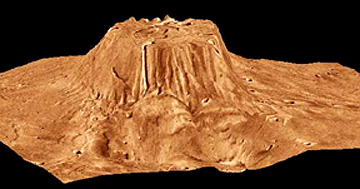
The two images below show a color version of the Volcano Tyrrhena. The first image does not give a sense of relief but when we confound topographic information with this image, a perspective view, marked by strong vertical exaggeration, gives a sense of its height:
19-34:
Both Vikings also transported separable landing vehicles that descended by parachute throughout the atmosphere. Viking 1 Lander touched down on July 20, 1976, and Viking 2 Lander on September 3. Both TVs successfully transmitted surface views, in color, of the immediate ground, up to the visible horizon.
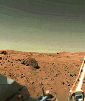
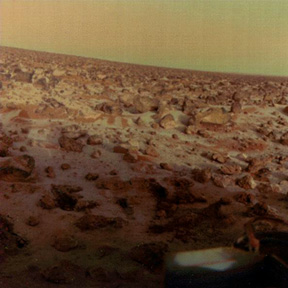
The two Viking Landers were exceptional ground-truth devices. These panoramas
from them reveal a red iron-coated surface, consisting of rocks (the largest
> 2 m [6.6 ft]) mixed with sand and dust, some piled into incipient dunes.
In other views, some rocks look like vesicular basalt. Note the yellow-brown
tones in the lower, dusty layers of the sky's rarified gas envelope (mainly
carbon dioxide). This stationary observatory was also equipped with magnets,
a seismometer, an x-ray fluorescence spectrometer (that receives samples from
a movable scoop), a miniature meteorological station, and three experiments
seeking signs of metabolic action (mainly, as gases released or absorbed)
by biogenic matter (none found).
19-35:

Primary Author: Nicholas M.
Short, Sr. email: nmshort@epix.net
Contributor Information
Last Updated: September '99
Site Curator: Nannette Fekete