
Before looking at some more representative images, we set up a geologic framework for Mars: the planet, fourth from the Sun, is a little more than half Earth's diameter at 6,793 km (4,218 mi), about double that of the Moon, and has about 1/10th its mass. Mars’ lower density implies a small metallic core, now solid, as borne out by the lack of a distinct magnetic field. It rotates once every 24 hours and 37 minutes (Earth time). Its surface temperatures range from -140° to 20° C. From Earth-based telescopic observations, we suspected Mars had oxidized, iron-rich materials at its surface, was subject to dust storms, and had ice caps at both poles that alternately expanded and contracted over a Martian year (687 Earth days). The storms implied at least a thin gaseous envelope. Spectroscopic measurements indicated CO2 and maybe nitrogen. The Mariner/Viking missions greatly modified our concepts of the Martian landscapes. Consider the generalized landform maps of the two Martian equatorial hemispheres, drawn on a Lambert equal-area projection from mission results, as shown here:
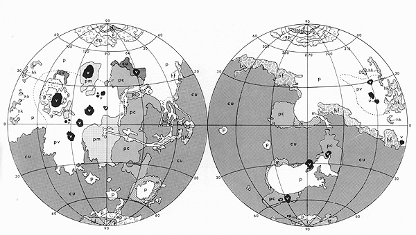
From T.A. Mutch et al., The Geology of Mars, © 1976. Reproduced by permission of the Princeton University Press, New Jersey.
The lower polar hemisphere contains cratered terrain (cu), considered to be billions of years old (and the likely source of the 3.5 b.y. old meteorite containing organics, found in Antarctica), where the bulk of the larger impact structures survive. Much of the upper hemisphere has plains units (p), many thought to be volcanic flows (pv) (mainly basalts?) and volcanic constructs (v) (such as shield volcanoes), some of whose ages could be less than one-half billion years. Other subdivisions include cratered plains (pc) and moderately cratered plains (pm). Unusual or specialized units consist of channel deposits (c), grooved terrain (g), knobby hummocky terrain (hk), fretted hummocky terrain (hf), chaotic hummocky terrain (hc), and mountainous terrain (m). Units confined to the polar regions are: permanent ice (pi), layered deposits (id) (thought to be layers of windblown dust interspersed with ice), and etched plains (ep). As with Venus, structural signs of plate tectonics are absent.
Many features in these categories are also landmarks and physiographic provinces. In the left hemisphere, the three volcanoes in a row (Ascraeus Mons [top], Pavonis Mons [center], and Arsia Mons [bottom]) are in the Tharsis Montes group and the two large ones above and to the left are Olympus Mons (largest volcano in the solar system) and Alba Patera (a caldera-capped volcano). The long, curvilinear feature (c) near the equator in the left hemisphere is the great Valles Marineris, many times longer and much deeper than the Grand Canyon, with associated chasmas or tributary canyons. In the right hemisphere, the large area (p) in the southern half is Hellas Planitia, site of the biggest impact basin on Mars, cut into ancient terrain and backfilled with lava.
19-36:
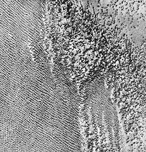
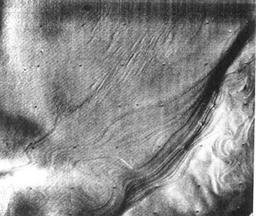
The missions confirmed the Martian atmosphere consists of 95.3% CO2, with the remainder being mostly N2 (2.7%), argon (1.6%) and minor O2, CO, and enough water, if condensed, to fill an average swimming pool. Atmospheric pressure averages 7 millibars or about 0.7% of Earth’s, but windstorms within this thin envelope can reach speeds greater than 200 km/hr (124 mph). Despite the very low density of today's Martian atmosphere, its high speed winds can add to erosive sculpturing, and can deposit uplifted dust and sand into vast dune fields. The Viking Orbiter image below contains transverse (elongated, or parallel) and barchan (crescent) dunes laid down in a plains setting.
A second image shows parallel dunes on the left and barchan dune on the right.
19-37:
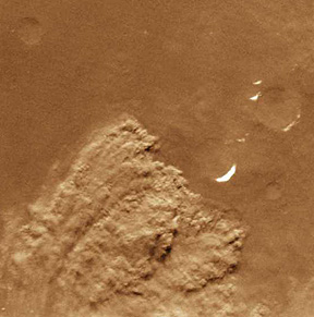
Both Mariner 10 and the Viking Orbiters gathered many images showing various aspects of atmospheric circulation, such as this view of spiraling clouds above the martian North Polar region; note also the bright patches of ice.
As further proof that Mars is meteorologically active, a dust storm was caught in the act of happening:
The martian dust and sand is frequently spread out as wind streaks.
The dominant constituent of the polar caps is CO2, but minor amounts of water may be locked within it and water may also be concentrated subsurface. The next views show the South Polar ice cap (top) and North Polar ice cap (bottom) (which may contain more water) near their maximum growth stage, during a Martian winter. This winter recurs about every 685 Earth days at each pole. In about half that time the polar ice at one pole shrinks as summer warming evaporates the frozen gases, and the opposing pole experiences ice condensation and growth:
Closer looks at the sides of the polar caps revealed prominent alternating bands of light and dark materials, as seen here in the south polar cap:
19-38:

Primary Author: Nicholas M.
Short, Sr. email: nmshort@epix.net
Contributor Information
Last Updated: September '99
Site Curator: Nannette Fekete