
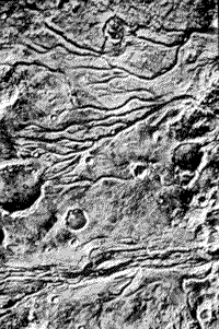
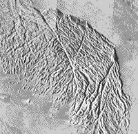
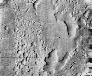
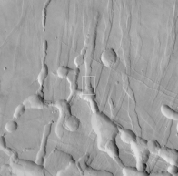
Some of the big surprises were infrequent but distinctive sinuous channels, whose morphology is much more similar to river channels that lava channels. One interpretation holds this morphology as evidence of sufficient water in the past, in lakes, groundwater or possibly oceans, to have initiated some sort of hydrologic cycle involving rain storms and runoff. Most water has since evaporated into space, although small quantities may remain frozen as underground ice. Nevertheless, significant water activity has recurred as evidenced by the types of dendritic channeling shown in these Viking Orbiter image mosaics:
 |
 |
The region depicted in the top image covers the Juvenae Chasma and Vedra Vallis.
These are runoff channels, a type confined to the ancient landscapes.
Stream flow is the favored origin, largely by comparing them with terrestrial
counterparts, but multiple lava flows are a possibility. Some channels seem
to originate at craters, which could imply that subterranean sources released
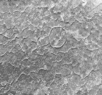
either water or lava, following impact offloading. The drainage pattern in the
bottom image resembles terrestrial patterns found in soft sediments or wind
deposits.
19-42:
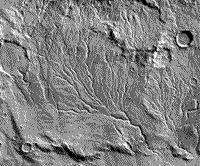
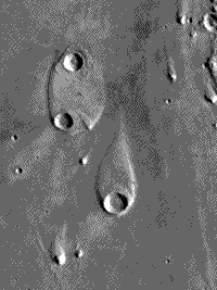
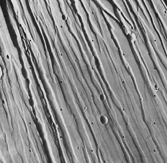
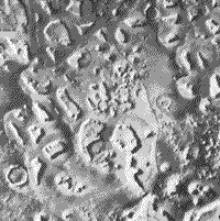
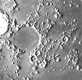
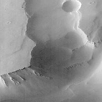
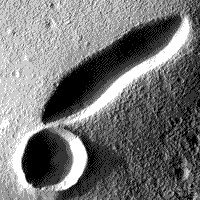
A second type of drainage we call outflow channelling. The channels typically are broad and deep, creating canyon-like depressions. This type of landform may have been associated with catastrophic scouring during abrupt flooding. A similar example on Earth is the Channeled Scablands of central Washington State in the U.S. that developed in just a few weeks from rapid emptying of a huge dammed lake after a natural breakup. Outflow features commonly occur next to chaotic terrain (top image, below; note the large outflow channel in the middle), in which surface units break into jumbled blocks and huge slabs, left behind after subsurface waters escape, leading to loss of support (a process called sapping). We consider a teardrop-shaped landform in Elysium Planitia (bottom image) a prime example of shaping by streamlining (analogous to aerodynamic sculpturing), in which water flowing from bottom to top has eroded plains material around the rim of a large crater and has terraced and perhaps redeposited debris towards the pointed end.
19-43:
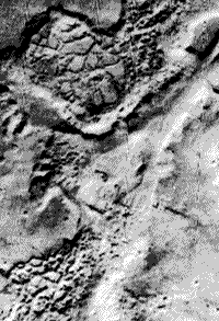
The Martian surface is amazingly varied, with landforms of diverse genesis¾ some probably related to water action, others to tectonic forces, volcanism, and wind¾ being given descriptive names. Here are four examples:
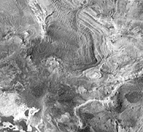
The mishmash of intersecting linear features, called grooved terrain , in this case may be a complex surface of eroded ash deposits or possibly joint enlargement of a now buried remnant of a volcanic lava unit.
In the next image is an example of
polygonal terrain, which resembles, on a huge scale, fractures found
on lava lake surfaces or patterned ground, associated with ice wedging in periglacial
regions (areas adjacent to ice sheets).
As is often true for volcanic terrains (such as the East African Rift), sets of close-spaced parallel grabens (fault-bounded downdrop blocks of crust) related to tension induced by loss of support after lava withdrawal have been found also on Mars:
The last photo shows fretted terrain,
found usually near cratered terrain, consisting of separated higher mesa-like
units, bounded by scarps and set within lower smooth plains. This terrain may
represent incomplete dissection of older landforms by water and/or wind.
The last image portrays etched terrain which consists of shallow depressions likely developed by wind scouring and deflation of easily erodable unconsolidated surface materials.
Other landform types given distinctive names (examples not shown; see the map near the top of page 19-12) include: furrowed terrain, knobby terrain, channeled terrain, etched terrain, and layered terrain.
19-44:
The importance of those landforms with fluvial signs is that they suggest a probability that water did exist in sufficient volume and concentration on Mars as an essential ingredient for the inception of organic molecules. Carbon, the other vital constituent, was certainly present as indicated by today's atmosphere. Whether these elements came from the interior or from meteoritic matter, during the accretion phase or later, is still uncertain. The absence of any viable organics in samples analyzed at the Viking sites does not disprove the possibility of biogenic forms in modern Mars. The sample may not have encountered organics there but they dwell elsewhere. Both sites were in younger terrains, so the nonoccurrence could mean that any earlier life or unorganized organic matter had perished by then.
The sensation in the scientific world during 1996, was the claim that a meteorite from Mars contained evidence of life. Scientists recovered twelve meteorites, mainly from the Antarctic, which they generally accept as coming from Mars, after impacts that hurled them into Earth-crossing orbits. These form a group known as the SNG meteorites (consisting of the Shergotty, Nakhlite, and Chassignite types). One, known as the Allan Hills meteorite (top), has several features interpreted as consistent with organic
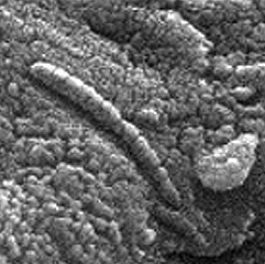
structures found in some ancient terrestrial rocks. This fragmental rock contains dark materials, thought to be old Martian crust, that date from 4.5 billion years ago. Golden-orange carbonate globules, dated at about 3.6 b.y., are considered evidence of a primitive ocean. Associated with the globules are small amounts of polycyclic aromatic hydrocarbons that, while not necessarily biogenic, are indigenous to Mars rather than contamination. Fossil-like bodies consisting of iron oxides (magnetite) and iron sulphides are present but even more lifelike in appearance is the elongated chain of tapering cylinders seen in the image (bottom, above). Needless to say, many skeptics have argued that this evidence is not persuasive¾ some similar features found in Earth rocks were inorganic. A recent report now claims that these tiny forms are indeed primitive bacteria but very similar to types still thriving on Earth¾ the implication is that this is just terrestrial contamination.
However, the possibility that they are genuine remains: if we certify life on Mars, the Earth would no longer retain its unique status as the living center of the Universe¾ although it is a huge leap from microscopic primitive organisms to the intelligence that then understands them. Suffice to comment that some scientists are touting these meteorite "life forms" as a pressing reason to formulate and accelerate a major space effort to return to Mars for more detailed exploration.
19-45:
And, after a 20-year hiatus in Mars exploration, the quest for onsite information about our red neighbor has resumed. First up was a launch in 1993, of the Mars Observer, a billion-dollar spacecraft, which, regretably, failed enroute. The Mars Global Surveyor followed on November 7,1996, with the launch directed by JPL. The spacecraft arrived for orbital insertion on September 12, 1997. In December of 1996 the Pathfinder mission was underway, to land a roving vehicle capable of viewing the local terrain and making sophisticated measurements. An orbiting spacecraft, whose task is mainly climatic measurements launched in mid-December of 1998.
From an initial orbital altitude of 400 km (249 mi), the Global Surveyor used the aerobraking technique, which involved progressive slowing through air friction (drag) with the thin atmosphere, until, after six months, the spacecraft lowered to 110 km (68 mi). From there, using thrusters to maintain this altitude, a mapping mission began in late-March of 1998 to last a minimum of 687 Earth days. A second lowering is planned for 1999.
The Global Surveyor has a wide- and narrow-angle camera system, the Mars Orbiter Laser Altimeter, a Thermal Emission Spectrometer to measure atmospheric heat and surface composition, a Magnetometer/Electron Reflectometer, and two other instruments. Among the first surface images, taken from the higher altitude in early October of 1997, are these two examples of the many views from the mission.
The Mars Orbiter Camera (MOC) can take pictures with resolutions of 3 m (9.8 ft). This resolution will improve slightly over time, as the orbital height lessens, because of the aerobraking effect. The next view, taken after the orbit lowered to the altitude chosen for the first major scientific measurements, shows details of the terrain surrounding an elongated volcanic caldera, 2 km in length in the Tempe-Marcotis Fossae region. Almost touching it is a round crater that may be impact in origin. The surface surrounding these two features is marked by small dunelike features probably built up by wind action
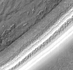
Layering of the bedrock of Mars (presumably volcanic flows) has been imaged at several martian locations. Here is an MOC view (at 7 meters resolution) of the wall of Candor Chasma in Valles Marineris that shows distinct layers.
19-46:
The Laser Altimeter (MOLA) yields maps and profiles that show martian relief. The next figure is a flat projection map of the entire martian surface produced from a large number of orbital lines with data taken at every 60 km (37 miles) yielding 27 million data points. Vertical resolution is 13 m (42 feet).
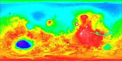
The southern hemisphere is, on average, 5 km (3 miles) higher than the younger northern hemisphere. The maximum relief on Mars ranges to 30 km (19 miles), about 1.5 times greater than that on Earth.
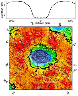
The large elliptical blue region in the red southern hemisphere is a huge topographic depression about 2100 kilometers (1300 miles) wide and up to 9 km (6 miles) deep, with a rim that reaches 1.5 km (1 mile) in relief. This is the Hellas Basin, so far the biggest impact crater known in the Solar System. To emphasize the size of this structure: If all material excavated from it were to be spread evenly over the 48 continental United States, a layer of debris some 3.5 km (2 miles) thick would accrue.
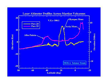
Probably the most dramatic of these
MOLA data plots presents an exaggerated profile across Olympus Mons and Arsia
Mons/Alba Patera.
19-47:
One of the most exciting and informative scenes taken by the Global Surveyor combines a color view of the North Pole Ice Cap with topographic data obtained from a series of Laser Altimeter passes to produce this three-dimensional view:
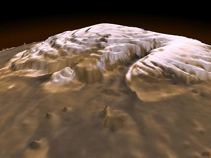
The size and amount of ice (which the spectrometer confirmed was largely water ice) was less than anticipated from pre-Surveyor observations. The cap is roughly 1,200 km (746 mi) across (crudely circular) and as much as 3 km (1.9 mi) thick. With an average thickness of 1 km (0.62 miles), the volume of ice is about 1.2 million cubic kilometers (288,000 cubic miles), roughly half that of the Greenland Ice Cap on Earth. The cap's general surface is quite smooth, but the ice cap is cut by large, deep (up to 1 km; 3,280 ft) steep-walled canyons and troughs, which may have come from cracks enlarged by wind and possibly meltwater. The amount of water located at the North Pole, and lesser quantities now at the South Pole, does not seem sufficient to have once made an ocean over parts of Mars. It instead may be the remnants of any seawater that could have existed in the Mars past. Any relationship of this surviving water to the river-like channels on Mars is still speculative. Water may be widespread even now but would be subsurface. Detecting that water is one of the objectives of future Mars missions.
Dust layers in the polar caps has been shown before in this subsection on Mars. Details (at 25 m resolution) have been acquired by the Mars Orbiter high resolution camera. Here are layers in the South Polar ice cap:
19-48:
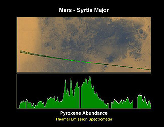
The Thermal Emission Spectrometer
can identify some individual minerals and determine in a semi-quantitative way
their proportions in the surface rocks (believed to be primarily basalt and
andesites). The mineral Pyroxene (an iron-magnesium silicate) occurs in rocks
found in Syrtis Major. Note its variable distribution, with the largest amounts
present in the darker areas of this region.
19-49:
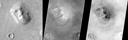
MGS sheds new light on the famous "face" on Mars first noted in a Viking image and seized upon by zealots favoring a lost civilization on the Red Planet as an artifact carved (like the Sphinx) into bedrock. The left view is the Viking image; the center (MGS) view shows the feature to have several mini-mountain peaks partly responsible for the fortuitous shadowing that highlights the face; the right view is a negative of the center view that recreates the shadowing. Judge for yourself what this feature might really be.
A recent (April 1999) report by Global Surveyor investigators has created a flurry of excitement about an aspect of the martian crust which may be a counterpart to the mobile segments of terrestrial crust that are involved in the concept of Plate Tectonics - a cornerstone in our understanding of the operation of the Earth's outer layers embodied in the idea of "continental drift". The Global Surveyor magnetometer has picked out a series of magnetic stripes on Mars that systematically reverse their polarities. Thus:
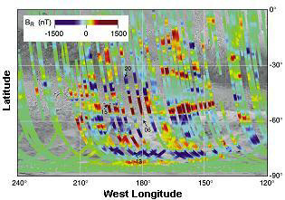
These martian strips are found mainly in the older terrains of the Southern Hemisphere. They trend at high angles to the polar axis. The implication is that this crust was formed by outpourings of lava from analogs to the terrestrial oceanic ridges that push the plates towards subduction zones (no such features have yet been recognized on Mars nor are there changes of mountains that result above these zones). This also suggests a much stronger magnetic field during early martian times; this would indicate a (partially) molten core. The full meaning of this new discovery is yet to be assessed.
Launched on December 4, 1996, JPL's Pathfinder landed on July 4, 1997, in the Ares Valle near the earlier Viking 1 site . This shorter transit time (seven months) resulted from a better alignment of Mars and Earth in their orbits The primary scientific purpose of Pathfinder was to release the small Sojourner Rover, guided from Earth through the lander's communication system. The Rover moved independently (after departing the lander down a ramp) up to 20 m away on its six, flexible, rocker wheels, to take pictures and bring its spectrometer against rock surfaces for analysis.
This microrover, which weighed 11.5 kg (25.4 lbs), measured the follwoing: length = 630 mm (24.8 in), width = 480 mm (18.9 in), and height = 280 mm (11.0 in). Using power from a solar panel, Sojourner moved at a maximum speed of 40 mm/min (0.13 ft/min) during the Martian day. Its front and back wheels moved independently to control its steering. The microrover used a stereo camera, mounted at its front, which imaged objects in its path. Each excursion was intermittent, because operators on Earth determined direction changes to reach target rocks and avoid obstacles. This took extended time periods because of the long distances radio and video signals traveled back and forth. When it encountered small rocks, the wheels raised up to glide over the obstruction.
The stereo camera system took images of the surface around the lander, with color filters. Sojourner's camera also collected images (mainly rock close-ups). Next, we show a panoramic montage of most of the surrounding site, in which we identify (using friendly names that speak a personal touch) some of the rocks that it visited.
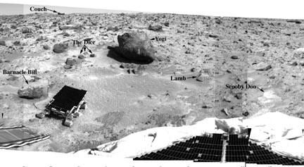
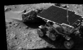
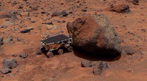
Many of the rocks are grayish on fresher surfaces. These surfaces appear weathered and pitted, and often are, at least partly, dust-covered. A typical large rock is Yogi (shown below), which appears to have a reddish dust blanket on one side and a sharp boundary with fresher rock (right side).
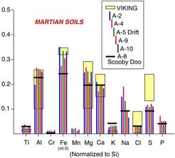
The primary instrument on the microrover is the alpha-proton-x-ray spectrometer (APXS). This instrument uses high speed alpha particles to bombard soil or rock surfaces. These particles generate a back scattering of alpha particles, alpha-proton particles, and x-rays, whose energies as determined at the detectors are indicative of a wide number of elements. It thus detects, quantitatively, elements such as those in rocks, i.e., Si, Al, Ca, Fe, Mg, K, Na, Ti, Mn, Cl, S, P, O, and C. It can report these elements in their elemental form or as oxides. The diagram below is a histogram of many of these elements from Barnacle Bill, Scooby Doo, Yogi, and some soil sites. Barnacle Bill's composition is close to that determined earlier at the Viking site but the other rocks and soils are different.
The next graph (left, below) is a plot of values of elemental ratios of Fe/Si and Ca/Si from the Pathfinder site, compared with certain Earth rocks. The Martian rocks are definitely not basalt. They plot close to but not within the compositional field of the terrestrial volcanic rocks known as Andesites. When we recalculate the elemental composition of the Pathfinder rocks into what petrologists term normative rock compositions, we see that the mineralogy is similar to andesites (right).
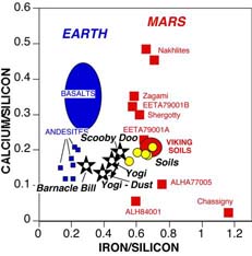

But the presence of normative quartz (leftover silica, after we assign all other SiO2 to the other oxides), technically makes this rock type a dacite. Andesites and dacites are the common volcanic rocks emitted from continental volcanoes, such as those along the Ring of Fire (e.g., the Pacific Coast Cascades). The presence of these rock types at this Martian site, if typical of other sites, suggests that the Red Planet had melted and differentiated, so that at least part of its crust is andesitic. Paul Lowman (author of Section 12 of this tutorial) had postulated more than a decade ago that an andesitic primordial crust probably developed early in Earth history and may be the norm for other inner planets.
19-50:
Landers have gathered compositional data at three widely-separated Martian sites (the other two are the Vikings). In general, the sites are similar in their chemical makeup. This may simply mean that the Martian crust is homogeneous, but even more likely is the explanation that Martian wind circulation has scattered and homogenized compositional differences across the planet. The distribution of rocks and boulders at the Pathfinder site further supports earlier ideas that at one time in the Martian past there was considerable water cover and resultant flow currents, causing a pattern sometimes observed on Earth as flood-related.
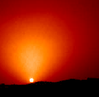
The last Pathfinder image we show below is a classic sunset picture, taken through the thin, dusty, Martian atmosphere that produced a fan-shaped glow around the distant Sun.
A series of more than 10 spacecraft will be sent to Mars by 2005. The first, the Mars Climate Orbiter, was launched on December 11, 1998 and will reach the planet on September 23, 1999. This was followed on January 3, 1999 by the Mars Polar Lander which will arrive on December 3, 1999 where after setting down on the surface, it will release a rover and two "microprobes" that will penetrate the soil up to a meter. There will be a series of Mars Surveyors launched in the next five years culminating in Surveyor 2005 which will gather samples for a return to Earth. All of this is connected with the U.S. decision to eventually send astronauts to Mars, after it has been thoroughly explored with these probes.
It has been known since 1877 that
Mars has two small satellites - Phobos (mean diameter = 21 km; [13 miles]) and
Deimos (17 km [10.6 miles]). Mariner 9 captured the first detailed views of
these tiny bodies. Their irregular shapes are similar to asteroids that have
been imaged by radar and their dark surfaces are suggestive of the carbonaceous
chondrite matter thought to comprise these bodies; these insinuate that the
martian satellites are captured strays from the asteroidal belt that extends
between Mars and Jupiter. Here is a view of Phobos:
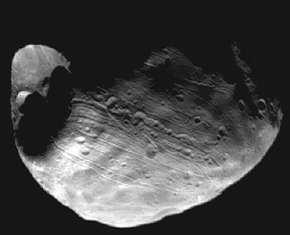
Small craters dot its surface but one large one, named Stickney, came close to disrupting it. This cratering is consistent with the likelihood of collisions with smaller objects during a period of residence in the asteroid belt. The grooves may relate to this crater.
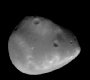
Deimos has fewer craters and a smoother surface:
Mars, the outermost of the terrestrial planets, remains an exciting and diverse place to visit (perhaps by Man) in the foreseeable future. NASA, and much of the scientific world, continues to promote the idea of a Mars, Manned mission, sometime after the year 2010. In the meantime, several more orbiters, probes, and landers will seek additional critical information to support such a venture. The International Space Station, now under construction, and scheduled for completion in 2002, would be a favorable launch pad for Man's great adventure to the Red Planet.
19-51:

Primary Author: Nicholas M.
Short, Sr. email: nmshort@epix.net
Contributor Information
Last Updated: September '99
Site Curator: Nannette Fekete