
The Apollo Program and Follow-Ups
The culmination of the great push to the Moon, announced in 1962 by President
John F. Kennedy as a major goal for all humankind, were the six manned landings
between July 1969 and December 1972. The Lunar Orbiters had imaged each site
at various times, as seen in this next set of panels:
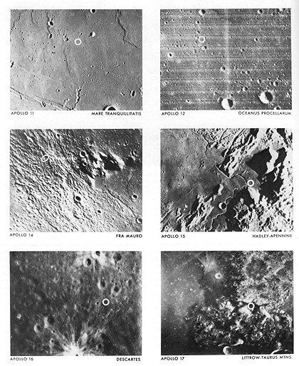
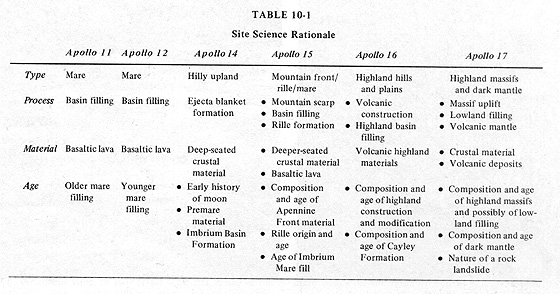
The following table summarizes the science rationale for visiting each site:
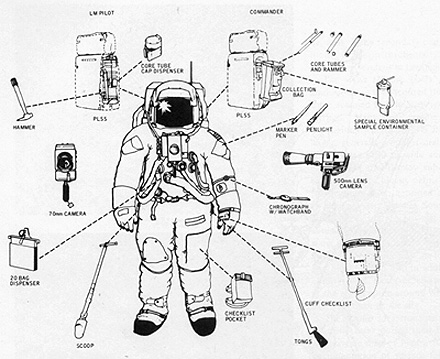
Each astronaut involved in excursions after landing was well-equipped to operate in the low gravity (1/6th that of Earth), airless surficial environment, as depicted in this figure:
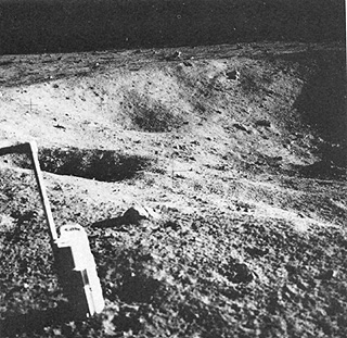
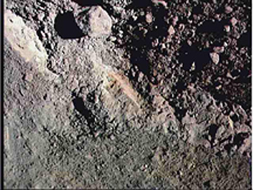
Apollo 11 and 12 sites were both in mare terrain. Apollo 12 also sat astride ejecta within a ray coming from the crater Copernicus. Apollo 12 represented a remarkable achievement in navigation, setting down within easy walking distance of the Surveyor III spacecraft remaining from an earlier mission,; pieces of Surveyor were returned to Earth to study the wear on its surface from micrometeorite bombardment. A view of a small, local crater near the Apollo 11 LM is typical of mare scenery:
19-19:
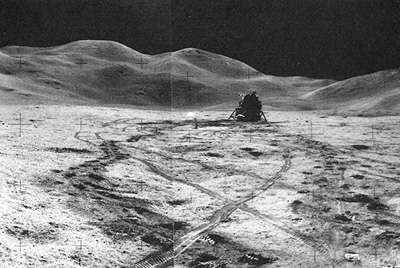
Apollo 14 was in Fra Mauro ejecta, emanating from the huge cratering event that produced the Mare Imbrium Basin. Apollo 15 landed near the Apennine Mountains, made of rim rocks, which are lunar crust, pushed up when the Imbrium Basin formed. These mountains, shown in the background of this view that also pictures the LM, rose as high as 4.7 km (about 3 miles):
19-20:
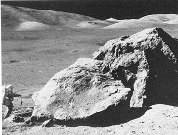
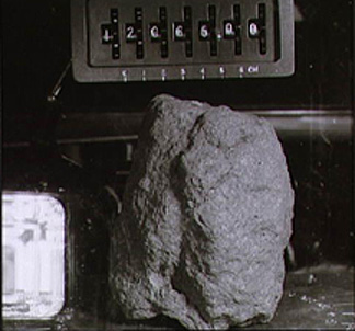
Apollo 16 visited Highlands units, consisting of the Cayley Formation (supposedly volcanic deposits, as interpreted pre-launch, but shown during the mission to be consolidated impact ejecta). Apollo 17 also sought volcanic pyroclasic units, predicted to occur around the Taurow-Littrow Mountains but, except for the notable orange layers (glass droplets splashed out of mare lavas before they hardened) within the regolith (debris "soil"), the rocks exposed in the massifs (high hills) were again made of ejecta. Some of the rocks at the 17 site were huge, as indicated by this view of "House Rock" which consisted a consolidated ejecta (a breccia); astronaut-geologist Jack Schmitt is standing nearby:
Some of the astronaut photography concentrated on black and white, high-resolution scenes of specific targets on the surface, such as this picture of the Apollo 17 landing site in the Taurus-Littrow region, where the last visit to the Moon occurred in December, 1972:
Familiarize yourself with the geography of this scene, and note especially the patterns of the massifs (hills in the highlands) that stand out as bright against the darker central lava-covered plains around the touchdown site. Now, look at this ground scene:
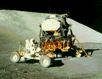
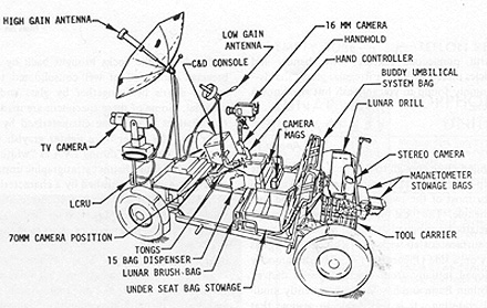
Astronaut Jack Schmitt (a geologist) took the photo, partly to show the Lunar Module (LM) sitting safely on the plains against a background of a massif (mountain block). Astronaut Eugene Cernan is at the controls of the mobile Lunar Rover, used for excursions up to several miles from the LM. The Rover, also called the "Lunar Buggy" is equipped as indicated in this schematic:
19-21:
One of the prime goals for discovery at the Apollo 17 site was evidence of volcanism other than invasion by mare basalts. The U.S. Geological Survey had forecast that volcanic deposits transported above the surface should be present. There was a moment of high excitement when one of the astronauts suddenly spot an orange layer in the regolith (surface "soil" debris), as photographed by him here:
When samples of the orange layer were studied after return to Earth, the material was seen to consist of small glass spherules. These are believed to be splash droplets tossed out of cooling lava during impacts into still fluid target lavas (probably with a solid surface crust).
Apollo 17 also shed some proof on a prediction made by the writer (NMS). Just before the Apollo 15 mission, he had attempted to calculate the thickness of the ejecta deposits that he had proposed as the principal surface units in the Highlands. The basis for this calculation was simply to determine the amount of material that would be excavated and tossed out of lunar (impact) basins and craters larger than 1 km on the frontside of the Moon. A terrestrial cratering model was assumed. The result indicated thicknesses on the Highlands to range between < 1 km to just over 3 km. Maximum thicknesses would be near the edge of large basins; the central Highlands would contain, on average, about a kilometer of ejecta (on the surface of which would develop, both in the Highlands and the Maria, a thin surface layer - the regolith). After Apollo 15's seismograph began operating, indications favored a widespread low velocity layer on the Highlands which seemed to correspond to this ejecta unit. The author published this generalized isopach (thickness) map shortly thereafter:
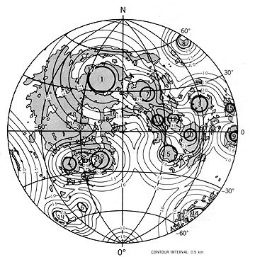
As preparations were made to send Apollo 17 to Taurus-Littrow, between and east of the Mare Serenitatis (7) and Mare Tranquillitatis (11) Basins, the writer predicted from this map a thickness of 3 km for that site . On landing, astronaut Jack Schmitt noticed that North Massif was a kilometer and a half high mountain made up entirely of breccia (consolidated ejecta). A small portable seismometer then determined that there was a kilometer and a half of low velocity (ejecta) below the site. These two observations totaled 3 kilometers, either a remarkable confirmation of the isopach map at that point or a very lucky coincidence.
The Apollo program remains the paramount achievement of Man in Space. The greatest reward from the journeys to the Moon lies in the nearly 368 kilograms (810 pounds) of rock samples collected by the astronauts. Almost three decades later, scientists continue the most intense analysis and scrutiny of any natural substances taken from a planetary body. Starting in 1970, every year in March, hundreds of geoscientists meet at the Johnson Space Center near Houston, Texas, for the annual Lunar and Planetary Science Conference, to report on new findings and exchange hypotheses on the interpretation and implications of recent data. From examining the lunar rocks several fundamental ideas have emerged: differentiation of a primitive planetary body, the nature of its early surface, the pre-eminence in non-mare rocks of shock effects from impact cratering, the age and history of the Moon, and its origin. The prevailing opinion is that it derived from accretion of terrestrial debris hurled into space after being ejected from a huge impact on the early Earth that resulted in crustal/mantle materials attaining orbital velocities. A variant of this model, held by some, is that much of the material came from the incoming body, probably an asteroid whose size approached that of Mars).
The appearance of typical lunar rock specimens is shown in the three displays here:
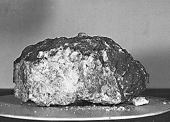
First is a specimen of lunar basalt from the Apollo 12 site; it is fine-grained and pitted by micrometeorite bombardment. This is the prevalent rock type in the maria.
Next is an anorthositic gabbro, a whitish rock dominated by feldspar. It is probably typical of the bulk of the original lunar crust, representing crystals of plagioclase that floated upwards in the cooling magma that developed during the Moon's first general melting. Note the black glass that coats part of the sample, presumably plastered on the rock as it was transported from an impact crater that made the glass.
Finally, from the Apollo 17 site, the large central rock is a breccia, that is, a rock composed of fragments of other rocks that accumulate from various (usually distant) sources which are then welded together by heat and pressure.
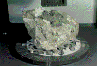
The large central rock is a breccia, that is, a rock composed of fragments of other rocks that accumulate from various (usually distant) sources, which heat and pressure then weld together. These fragments represent impact debris from more than one area of the Moon that make up the principal deposits of the outer layers of the Moon–part of the 1-3 km (about 0.62-1.86 miles) thick, lunar-ejecta blanket, first proposed and described in 1971, by the writer of this tutorial. The dark material in this specimen is basalt, the solidified end product of iron-rich lava that fills lunar marias. The lighter rock fragments probably originated from the lunar highlands, which we see from Surveyor and Apollo samples that show them to consist of rocks with a high percentage of grayish feldspars (Ca-Na aluminosilicates) that cause the highlands to appear lighter in tone (higher albedo or reflectivity). The smaller rock samples surrounding the large specimen are vesicular basalt pieces (dark) and individual highlands rocks (light), collected nearby on the same mission.
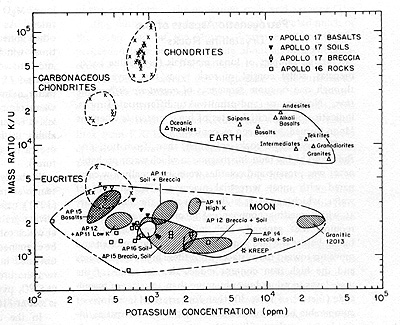
Analysis of lunar samples brought to light several distinct features. Some breccias when individual fragments were examined disclosed definitive evidence of shock effects, indicating that these rocks were debris involved in major impacts. Shock effects were found also in lunar soil samples. Chemically, the lunar rocks were mostly in a class by themselves, being different from their terrestrial rock type counterparts. They were deficient in iron, low in volatiles (including potassium and sodium), and were totally anhydrous (meaning that water was not present when they formed; water found on the Moon is discussed below); compared with Earth rocks, they were exceedingly fresh, showing almost no signs of alteration. As an example of their chemical specificity, examine this diagram which plots the ratio of potassium (K) to uranium (U) versus changing potassium content; note that both meteorites and terrestrial igneous rocks plot in different areas of the diagram than the lunar rocks.
19-22:
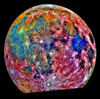
The views presented so far highlight the two dominant characteristics of the lunar surface: 1) the mare/highlands dichotomy, and 2) the abundance of circular features, nearly all being impact craters and basins but some of probable volcanic (caldera) origin. This next scene emphasizes both characteristics by showing an exaggerated false-color image of the front side of the Moon, taken by the multispectral vidicon onboard the Galileo spacecraft (described later in this section). The highlands, with their higher reflectances, appear in shades of red and orange and the lower reflectance maria are in blues and greens.
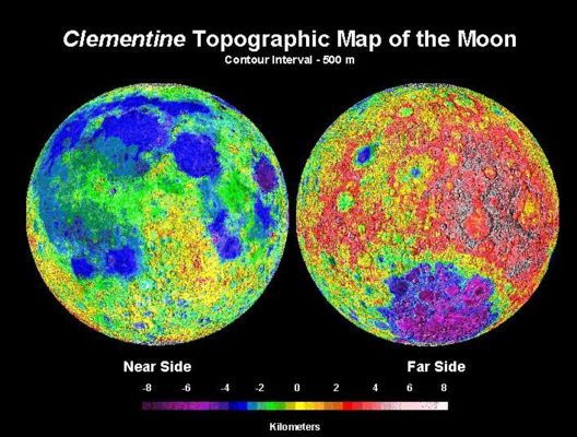
After Apollo, the Moon was not specifically revisited for 22 years, until an unmanned spacecraft, Clementine (funded by the Department of Defense), orbited it to conduct mapping studies between February 19 and April 21, 1994, using UV/Visible, Near IR, and High Resolution Cameras, Lidar (a radar altimeter), and a radar-like unit that transmits in the S-band radio frequency (2.293 GHz, or 13.19 cm wavelength). Look first at a topographic map of the front and far sides of the Moon, in which stereo data provided elevation differences from high resolution photographs and radar altimetry data, acquired by the Clementine spacecraft as it orbited the lunar surface.
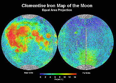
Among specialized products were more detailed maps of lunar topography (elevations) and global maps of the distribution of several chemical elements, such as iron (Fe) and titanium (Ti), determined by analyzing reflectance variations at 0.75 m m and 0.95 m m, where these elements absorb irradiation. The Fe map, reproduced below, indicates that, while iron is widespread, its maximum concentrations are in a broad region on the nearside, roughly coincident with the vast lava outpourings into Oceanus Procellarum and several other mare basins.
Clementine made a controversial discovery, which, if proved correct, has major implications for humans returning to the Moon. Its S-band radio unit detected abnormal reflections from the rim of a huge crater at the lunar South Pole, in areas permanently sheltered from the Sun's rays. These reflections could be due either to water ice or to some abnormal surface roughness condition. If indeed ice (enough to fill four large swimming pools), then this precious material (which supplies water needed for life and also oxygen, when broken down by electrolysis) might allow us to establish a manned base on the Moon. Transport of sufficient water and oxygen for long stays is presently beyond our technical capability. Some scientists postulate the source of this ice, if it truly is there, to be infall of cometary material (comet heads contain ice).
This observation, and the intriguing results of Clementine's compositional mapping, has led to a follow-on mission. For the first time in 25 years, NASA has returned to the Moon with a small, but versatile orbiting satellite, called Lunar Prospector. The entire mission including data analysis is another effort by NASA to achieve high scientific returns at relatively low cost (for LP, $65 million). Launched on January 6, 1998, by an Agena rocket, Prospector now is operating in a 100-km high circumlunar polar orbit, from which it can map the entire Moon over a 3-year lifetime in more detail than Clementine provided. Here is an artist's sketch of the spacecraft:
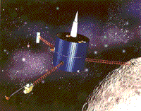
The spacecraft, just 1.4 m (4.5 ft) high and 1.2 m (4 ft) in diameter, weighing 300 kg (660 lbs), receives its power from solar cells that surround its exterior. An S-band radio sensor designed to measure lunar gravity employing a Doppler effect procedure, sits on top of a conical communications antenna (top). At the end of the 8-ft boom or mast extending to the front left, a Magnetometer/Electron Reflectometer will conduct improved measurements of the Moon's magnetic and particle fields. At the end of the left rear mast is the Gamma Ray Spectrometer, which can detect these elements: U, Th, K, Fe, Ti, O, Si, Al, Mg, and Ca. On the right boom are the Alpha Particle Spectrometer that will measure radon gas to assess lunar radioactivity as a clue to volcanic and other current events, and the Neutron Spectrometer that will determine the presence of hydrogen and can detect water ice (its confirmation from Clementine results is a major goal).
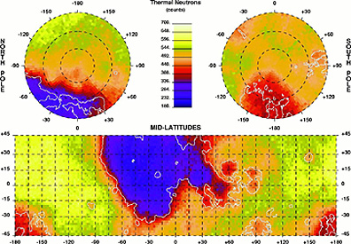
A plot of the varying thermal neutron flux, as determined by the Neutron Spectrometer, show a wide area of low neutron counts (resulting from high neutron capture) associated with the maria on the frontside and near the North Pole and higher counts in the highlands.
The first results on detecting ice were released during an exciting press conference, held on March 5, 1998. Around both poles, the neutron spectrometer has indeed detected neutrons, released from hydrogen by natural cosmic ray bombardment of water ice in craters with sheltered shadow zones. The initial estimate of the amount, to be determined more accurately with later observations, is 10 to 300 million tons. If melted, this larger number would fill a "lake" 10 square kilometers in area (3.1 x 3.1 km) to a depth of 10 meters. Surprisingly, the North Pole region contains about 50% more ice than its southern counterpart. The source of the water ice is probably residues from cometary bodies that impacted the polar regions, forming craters but allowing much of the comet mass to survive embedded in the target. The implications are encouraging for future exploration of the Moon, to the extent that we can establish and occupy a manned base facility over extended time because of the availability of vital water (for consumption and as a source of hydrogen, suitable as a fuel). However, landing in polar regions is technically more difficult but doable. The dream of a permanent observation post on our satellite is now much more feasible.
More details on Lunar Prospector are given at the National Space Science Data Center Web site and the Mission Management Home Page at NASA Ames Research Center. As NASA accrues and releases data and maps, we will place them in the Web version of this tutorial and in later CD-ROM versions.
An excellent synopsis of the major scientific information gained from, or supported by, the Apollo missions is found at this site.
19-23:
There are literally thousands of informative and often exotic images of the Moon, taken by various remote sensors. Reluctantly, we must take leave of our local satellite to begin an impressive journey through the Solar System. We start with the two innermost planets–Mercury and Venus.

Primary Author: Nicholas M.
Short, Sr. email: nmshort@epix.net
Contributor Information
Last Updated: September '99
Site Curator: Nannette Fekete