
Geologic Folds from Space
Space imagery is well-suited for us to recognize and interpret types of distortions of layered strata that produce such geologic structures as folds, faults, and fracture sets (joints). Some of these structures are so small that we must identify them on the ground. However, larger features often show obvious patterns of geometric curvature or displacement that stand out in relation (context) to neighboring features, as best displayed in space images covering extensive areas. We used the Waterpocket Fold to introduced this idea. Here, we take a quick look at classic folds in Iran and northwest Africa. Elsewhere in this tutorial (e.g., in Section 8 on Radar), we describe other examples of folding depicted at regional scales. Then , we look at two illustrations of how we can detect faulting from ground offsets and, more subtly, from discontinuities of landforms. Next, we illustrate the advantages of space imagery in picking out lineaments (usually fractures in the outer crust that may be faults), together with an appraisal of how these can often be misidentified and misinterpreted. We close this section with a practical example of how fracture analysis leads to a successful search for a valuable natural commodity water.
This full Landsat scene covers part of the Zagros Mountains along the southwest coast of Iran by the Persian Gulf. These mountains consist mainly of elongate folds which arch upwards as anticlines and downwards as synclines. The anticlines here make up distinct landforms as high hills with central ridges that taper at either end (a condition referred to as a closed fold).
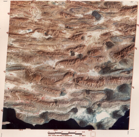
A simple analogy is to imagine cutting a watermelon in half through its longest dimension and laying the flat side on the floor. From above it resembles some of these Zagros anticlines. If we cut through it again across the long dimension at the mid-pointer, the exposed cross-section through green outer skin, white rind, and reddish center would appear similar to the folded strata within the anticlines.
2-11: Why don't you see the synclines in the Landsat image? ANSWER
One of the best exposures of a complexly folded mountain belt anywhere occurs in the Atlas Mountain system of northwest Africa. This group is part of the great orogenic belt that includes the Alps, Appenines, the Betic Cordillera (southern Spain), and other chains that we can trace eastward through Turkey into the Zagros Mountains. These belts began to form about 70 million years ago, when the Tethys Ocean (precursor to today's Mediterranean) started to close as the African Plate moved northward against the Eurasian set of plates. The orogeny climaxed in the late Cenozoic period and is still active. The Landsat scene below covers part of the Anti-Atlas mountains of southern Morocco. In the upper left is a deformed and metamorphosed core of Precambrian rocks against which the tight disharmonic folds of lower to mid-Paleozoic rocks (center) have been shoved northward along thrusts. The white sinuous band against a fold ridge is a dry stream or wadi.
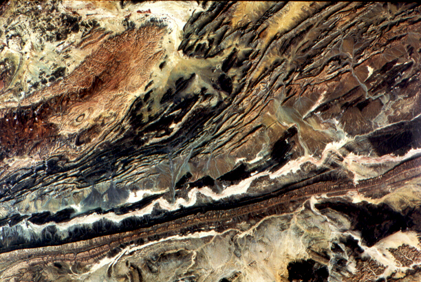
2-12: What does part of this Moroccan scene remind you of structurally in some other part of the world? ANSWER

Collaborators: Code 935 NASA GSFC, GST, USAF Academy
Contributor Information
Last Updated: September '99
Webmaster: Bill Dickinson Jr.
Site Curator: Nannette Fekete
Please direct any comments to rstweb@gst.com.