The SPOT Satellite
SPOT is an operational series of Earth-observing satellites, sponsored initially by the French government and managed by the French Space Agency, which, since the first launch in 1986, offers commercial multispectral data to users worldwide. From its 831 km (516 mi), sun-synchronous (10:30 A.M. equatorial crossing), near-polar orbit, SPOT revisits the same 117 km-wide (73 mi) ground tracks every 26 days, when its sensors look vertically downward (at nadir). However, operations can move its mirror sideways in both directions 27 degrees off-nadir, enabling it to view a 950 km-wide (590) corridor along its ground track. With careful planning, and optimal cloud conditions, it can revisit an area within this corridor seven times during a 26 day orbit cycle.
Images of the same area taken from different lateral angles on separate orbital passes can be paired, so that their parallax offsets permit stereoscopic viewing, thus facilitating a 3-D perspective of the area. These images are of great value to topographic analysts, geomorphologists, and others.
The payload sensor on SPOT is the HRV (High Resolution Visible). This name is slightly misleading, because in its multispectral mode, band 3 operates in the near-IR wavelength over the interval 0.79 - 0.89 µm (Band 1 = 0.50 - 0.59 µm [green] and Band 2 = 0.6 - 0.68 µm [red]). A separate unit in the HRV can also image in the panchromatic mode as a single band encompassing 0.51 - 0.70 µm. Instead of an oscillating scan mirror, the tiltable mirror (set either on or off-nadir) sends light from a scene to a linear array of tiny detectors, known as charged coupled devices (CCDs). (see page I-13 for details on how these devices function) The line of CCDs receives photons simultaneously and very rapidly discharges in sequence into an electron current stream. This array then reactivates with photons almost instantly, as the array line moves to the next ground position along the forward track. In the panchromatic mode, there are 6,000 detectors in the array, each receiving light from a 10 x 10 m ground area, thus providing a resolution of 10 m for an image of 60 km (37 mi) width. The multispectral HRV contains 3000 detectors in the array, providing a ground resolution of 20 m. On each spacecraft there are two such HRV arrays, mounted side-by-side, each viewing its own 60 km swath width but the pair of images sidelapping to give an effective 117 km (73) wide coverage.
3-4: What are the major advantages and disadvantages of Landsat compared with SPOT? ANSWER
Kenya and the African Rift Valley
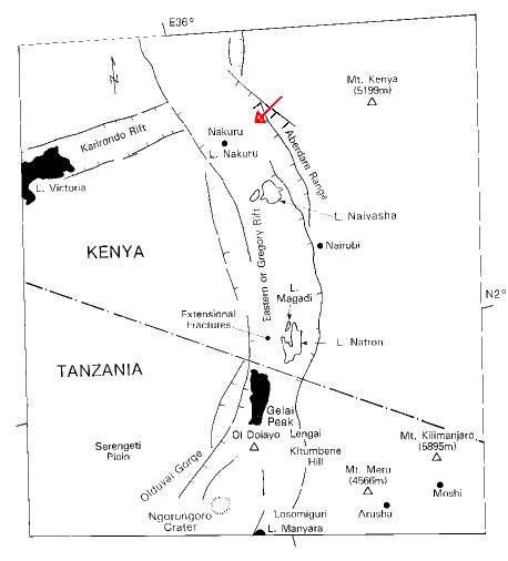
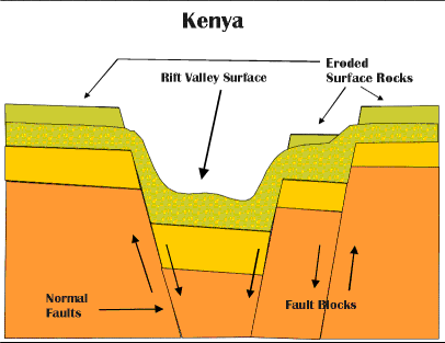
Now that we've described SPOT, lets look at one of its images and see what you can spot (couldn't pass up that one!). This example is an agricultural and forestry scene, just east of the town of Nakuru in Kenya, about 100 kms (60 mi) northwest of Nairobi, the capital . This town lies within the Great African Rift Valley of East Africa (described earlier on page 2-9) This rift zone, one of the largest in the world, is astride a regional uplift, where part of the eastern African continent is pulling away (an incipient divergent boundary in the plate tectonics model). Within the rift, parts of the crust are dropping a long normal faults in a series of one or more steps as shown in the figure below.
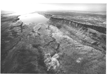
Some faults are young enough to remain relatively uneroded, so that they present a steep, often abrupt, face (called a scarp), separating the upthrown (upland) block from the downthrown (valley) block, as evident in the ground photos below.
 |
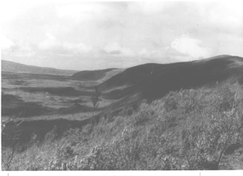 |
Along much of the rift, the land is an arid, semi-desert savannah (left photo, above). In other segments, the scarp is older, and weathered, and may be covered in part with forest or dense shrub, such as in the lower or (right photo, above). Most of the rift zone is underlain by a sequence of basalt (volcanic) flow units. The next SPOT scene is a regional mosaic made from all or parts of nine Landsat MSS images, of much of Kenya that extends over an area about 500 km (311 mile) wide, east-west.
|
|
|
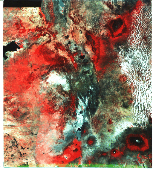
for major landmarks in this mosaic, including Mt. Kenya and Mt. Kilimanjaro in Tanzania, which are over 5,230 m (17,154 ft) high and therefore, snow-capped. The arrow points to the 10 km-wide subscene below, extracted from a full 60 km SPOT image, which was produced as a false color composite.
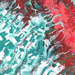
Whereas details are lacking in the mosaic, the SPOT image shows a remarkable amount of surface information. The edge of the Rift Valley passes from upper center to lower right, as marked by bright red areas that are associated with forest lands. )Note this section's internal texture which is an effect created by large tree groupings.) To its right is an area of rather uniform red, without any treelike textural pattern, which are interpreted as grass and shrub lands. The area to the left (west) is occupied mainly by irregular-shaped fallow fields, many of which are about 0.8 km (0.5 mi) long. Some fields appear in this color version as almost white, whereas others are in two dominant shades of blue. Inspecting the three individual SPOT bands (not reproduced here) shows the white fields are nearly white in each band and the blue fields are medium gray in band 1, darker in band 2, and very dark gray in band 3. The lack of any red areas in these two types of fields confirms that crop growth (mainly of coffee and wheat in this part of Kenya) is nil or too early to appear. Not having been there, we do not have any adequate explanation for this pronounced difference in tone between these fields. The dark tones could represent the prevailing color (also dark) for soils derived from the very dark basalts. But this fails to explain the nearly white tones for the other fields. They might be the signature of a grain crop, such as unharvested mature wheat (hence bright straw yellow, and thus very reflective in bands 1 and, 2 as well as, the IR band). Any further speculation without supporting ground truth would be frustrating. Note the pink tones in several areas of the scene including along stream courses and in the narrow stream canyons that are cut into the rift wall slopes. These pink tones may be due to two conditions: the foliage of some trees has only begun to develop new growth in this March 14, 1986 scene and the vegetation there is experiencing some stress due to deforestation as local farmers progressively clear the land.
3-5: Which part of the scene - the red grasslands or the area of fields - is lower? There is a clue to this. What is it? ANSWER
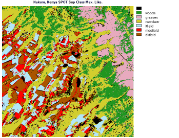
Some of the above ideas are implicit in the supervised, maximum likelihood classification of this scene, in which the classes chosen are: woods, grasses, newclear (new growth and cleared land), ltfield, medfield, dkfield (light, medium and dark fields). The results are quite believable, in that, the color patterns tend to be homogeneous and their distributions are logical. The extent of newclear is somewhat greater than we can discern in black & white images. There are some black areas in the classified image. Those black areas that appear scattered are simply unclassified pixels. But several areas have definite shapes and are probably small lakes or ponds ( there are flamingo breeding grounds in this region).
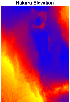
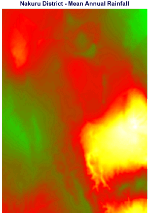
Quite by serendipity, during the preparation of this caption, we discovered that the IDRISI program uses two special theme maps of the Nakuru region as part of its training exercises. With permission, we repeat these here. On the left is an image of map of elevations, in feet, showing the Rift Valley to be as low as 5,690 ft (1,734 m)in blue, and the western uplands to reach to greater than 9,850 ft (3,002 m) in yellow. The SPOT is scene somewhere in the upper right . The image on the right is another map, which plots the annual rainfall in millimeters (green is wettest, then red, yellow, and white is driest) (note that in this equatorial region of East Africa there are two rainy seasons: winter and summer). Try drawing your own relationships to the SPOT scene from these maps.
3-6: Making a plausible guess from logic, in the Nakuru elevation map, where do you think the SPOT scene is located? ANSWER
 |
 |

Collaborators: Code 935 NASA GSFC, GST, USAF Academy
Contributor Information
Last Updated: September '99
Webmaster: Bill Dickinson Jr.
Site Curator: Nannette Fekete
Please direct any comments to rstweb@gst.com.