
The First ERTS Image: Dallas-Fort Worth
We close this Section on an historical note. The first scene processed by Landsat-1 (ERTS-1) was presented to an expectant and excited group of scientists, engineers, and technicians at the Operations Center of Goddard Space Flight Center, two days after its July 23, 1973 launch. The first product was a low resolution Polaroid of a subscene along an orbital path crossing through Kansas, Oklahoma, and Texas. Only several levels of gray tones were recorded since the image had not been adequately "stretched" to its maximum levels and hence details were lacking. Early on, not one of the experts present could locate this subscene based on its pattern. When fully processed later, it looked like this.
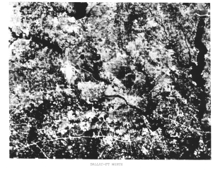
This is Dallas, Texas, near the center and a bit of Fort Worth along the left edge. The Trinity River runs through downtown Dallas towards the lower right. Interstate 20 passes E-W near the bottom of the scene and Interstate 30 follows parallel to it in the left center. I-635 is joined by I-20 on the east but in this scene, it is apparent that the former is not yet complete. Also, the white area in left center is the partially completed Dallas-Forth Worth International Airport.
The problem in identifying the location was that the atlas was rather out-of-date. Several reservoirs and lakes clustered around Dallas -Forte Worth, which were built since its publication, were not depicted in the atlas, although several appear in this subscene (elongated black patterns). Thus, no one initially could match the broader Polaroid pattern to this incomplete map pattern with satisfactory certainty. Eventually, some "wise men" deduced that this was the cause of the misfit, and Dallas-Forth Worth officially was recognized as the inaugural Landsat scene. However, in fact, the first full black and white scene that they viewed later that day was a stunning cloud free image of the Ouachita Mountains in eastern Oklahoma, and the first color composite covered the Monterey Bay to San Joaquin Valley section of California.
We reproduce that false-color composite here, for its historical significance and because the first version, seen here, serves as a collector's item because of a production quirk.
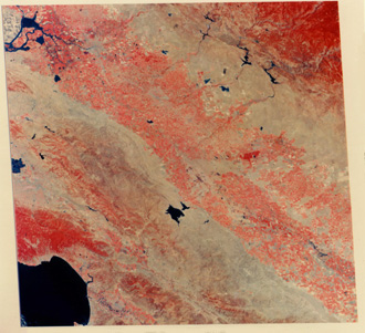
Before reading on, study this image to see the obvious anomaly. You may want to look again at the full scene images of New York City to refresh your awareness of image shape.
Remember that this shape (New York City image) is a rhombus with the upper part tilted to the right. This is the consequence of the Earth turning (counter-clockwise or W to E) under the spacecraft as it passes from north to south. Each successive scan sequence shifts slightly to the west. When processed, the image must express this by its vertical boundaries being moved progressively to the left. Somehow, this was not done correctly as the technicians rushed to get the first color composite to the waiting ERTS specialists, so that the upper part is tilted left instead of the usual right.
Now, lets leave "town" to journey again into the vast countryside, this time by considering views of southwest Utah and the Plains of Oklahoma, as examples of how remote sensing contributes to mineral and oil/gas exploration.

Collaborators: Code 935 NASA GSFC, GST, USAF Academy
Contributor Information
Last Updated: September '99
Webmaster: Bill Dickinson Jr.
Site Curator: Nannette Fekete
Please direct any comments to rstweb@gst.com.