
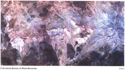
Here, we show a part of this area in a natural color aerial photo (somewhat overly red-brown in its printing).
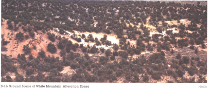
In a ground photo, we see the same area consists of gentle rolling terrain covered sporadically by cedar and sagebrush.
In the satellite image, this vegetation does not stand out as blotches of red, suggesting that cedar has a weak reflectance response in the near-IR.
5-4: How many different colors, that may relate to the alteration, can you discern in this ground photo? ANSWER
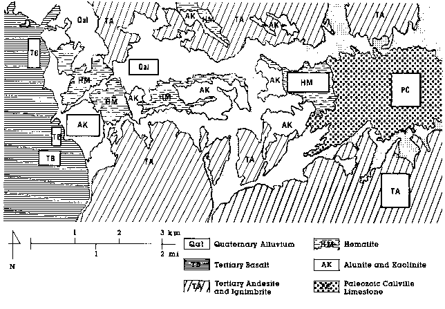
A published geologic map (Stringham and Brooke, 1962) of this area indicates a wide variety of alteration types have developed here. Their report states that mineralization consists of pyrite and chalcopyrite (copper-bearing). The latter is not of sufficient grade (amounts) for mining. A group of volcanic rocks called andesites show the most alteration. After they flowed into this region and cooled, volcanic gases and hot solutions modified some of them. One alteration type is kaolinite, a common clay mineral used in ceramics. It is light brownish-white at this location. A second, light-gray mineral is alunite, a hydrous potassium aluminum sulphate. The principal alteration mineral is hematite, the anhydrous iron oxide, which is medium grayish-red. Minor amounts of limonite are present, but the yellow-brown color of the space image corresponds mainly to altered hematite rather than the similar gossan. Very white areas of siliceous sinter are scattered about and a few areas contain natural sulphur, which comes from the breakdown of the original sulphides. In the ground-based photograph above, the light patch coincides with mainly a kaolinite-alunite (k/a) mix, and the reddish area is hematitic staining on weathered volcanics. To appreciate their general distribution in this subscene, examine the map below, a simplified version of the published map, which didn't reproduce well on this Web Page. This map can be printed for ease of reference in studying the images below.
We now consider a set of images we prepared to illustrate how to apply remote sensing data effectively in mineral exploration. Suppose, to start, that we are modern prospectors, searching for some metal (gold is the obvious choice, but copper is often the more likely find). If we had chosen a large region in which to hunt, we would be grateful for Landsat imagery that encompasses many thousands of square miles. Even in a full scene, the anomalous color in the White Mountain area (as this alteration district is known) would grab our attention because it is typical of a gossan signature. Our first logical step would be to zoom in on our image processor to the immediate area showing this signature
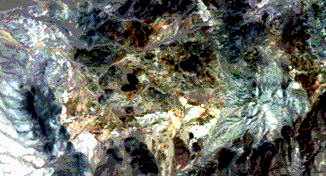
in a natural color (bands 1-3) rendition. Dark areas in the subscene relate mainly to the volcanics. On the left side, the map shows that these are basalts (an almost blackish rock, typical of Hawaiian volcanoes and of the Snake River volcanic plains of Idaho). Those dark areas at the top and bottom are somewhat lighter (but still dark grayish-brown) andesites, which are typical of volcanoes in the western U.S., such as Mt. St. Helens. White Mountain stands out on the right in light bluish-gray tones. It contains a radial pattern that corresponds to furrowed gullies draining down from its central peak. The main alteration zones make up a pattern with an east-west branch that meets a north-south segment on the left. Most of this alteration is displayed in the yellow-browns seen in the regional subscene. Other zones are much lighter (sort of tan) in this image. These two principal zonal types broadly match the hematite and k/a areas on the generalized map shown above. Areas on that map that we identified as alluvium (soil and loose surface debris) show up in several variant colors in the subscene. Those with a color similar to the hematite are alluvial deposits, derived from the altered hematitic zones. An equivalent subscene made from bands 2,3,4 (not reproduced here) contains very little discrete red patches, confirming the sparsity of active, reflectant vegetation.
5-5: Granted that it is troublesome to scroll up and down on this page, we still think it worth your time to compare the units in the geologic map with their approximate counterparts in the aerial photo at page top and the Landsat subscene near the bottom. You may conclude that the match isn't perfect. Why might this be so? ANSWER

Collaborators: Code 935 NASA GSFC, GST, USAF Academy
Contributor Information
Last Updated: September '99
Webmaster: Bill Dickinson Jr.
Site Curator: Nannette Fekete
Please direct any comments to rstweb@gst.com.