
6-3: For this Boston image, and all subsequent ones examined during this transcontinental overflight, locate the scene in your atlas. This will aid in correlating text to geography as mapped. ANSWER
6-3: For this Boston image, and all subsequent ones examined during this transcontinental overflight, locate the scene in your atlas. This will aid in correlating text to geography as mapped. ANSWER
Boston, Massachusetts
With this framework for describing and interpreting the various landscapes that make the U.S. so picturesque, we now embark on a simulated flight over the continent, using mainly Landsat images to portray typical surfaces in many of the provinces discussed above. We start on the East Coast in Massachusetts and proceed westward along a meandering line that brings us into northern California. Two of the images deviate south of that line but were chosen because they are excellent examples of the terrains and land uses in the provinces they represent. We recommend that you keep an atlas nearby to help in locating the features mentioned in the descriptions that follow. We do not provide maps for the tutorial. We think this self effort is good practice for learning how to relate space imagery to geographic data sources.)
The next scene lies within the New England Maritime physiographic province.
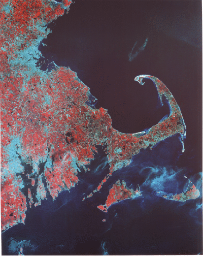
Geologically, this region is part of the Appalachian Mountain Belt that passes northward through Nova Scotia and Newfoundland. Most of the rocks underlying the province are igneous and metamorphic. We usually associate these rock types with the deeper parts of an orogenic belt, where temperatures and pressures were higher during their formation. Their presence at the surface today implies extensive erosion that stripped away the overlying sedimentary rock units after the main episode(s) of mountain-building and uplift. The landscapes typical of New England resemble parts of the Canadian Shield. Flatter areas are interspersed with low mountains, although peaks, such as Mt. Washington in New Hampshire and Mt. Katahdin in Maine, reach elevations exceeding 1,890 m (6,200 ft) and 1,590 m (5,200 ft), respectively. The rocky soils in the region do not favor farming, so that much of the land remains in forests. The predominance of deciduous trees accounts for the widespread reds in this false color composite (above). Most of New England experienced one or more advances of the Pleistocene continental glaciers that removed soils, laid down deposits, and carved out lakes.
The most conspicuous feature in this scene is Cape Cod, an east-west landmass built from extensive end morainal deposits that mark how far the lines of glacial ice sheets advanced. The sharp bend that ends at Sandy Hook represents. in part, modifications brought on by ocean-wave action. South of the Cape are the islands of Nantucket and Martha's Vineyard, also originating from fluvioglacial action. Lowlands associated with drowned rivers make up Buzzards Bay off the west end of the Cape and Narragansett Bay below Providence, Rhode Island. The bluish area along the Massachusetts coast is the central part of greater Boston whose harbor lies within Boston Bay.
6-4: Locate the town of Plymouth in Massachusetts; what famous event happened there? Is Gloucester in the image; where? ANSWER
6-5: Out in the ocean north of Sandy Hook is a peculiar curved cloud pattern. It is probably not a natural cloud. Speculate on what might have caused it. ANSWER

Collaborators: Code 935 NASA GSFC, GST, USAF Academy
Contributor Information
Last Updated: September '99
Webmaster: Bill Dickinson Jr.
Site Curator: Nannette Fekete
Please direct any comments to rstweb@gst.com.